This content was originally published by the Longmont Observer and is licensed under a Creative Commons license.
Forecast Discussion:
Winter Weather Advisory issued February 5 at 12:23PM MST expiring February 7 at 5:00AM MST by NWS Denver CO
Snow will increase in intensity and coverage across the northern mountains tonight and will continue through Thursday morning. A strong cold front will move through the urban corridor and eastern plains around midday Wednesday. Behind this front, light to moderate snowfall will fall through the afternoon and into early Thursday morning. The Wednesday evening commute will see hazardous travel conditions.
* WHAT...Snow expected. Total snow accumulations of 2 to 5 inches expected.
* WHERE...Portions of central, north central and northeast Colorado. This includes the cities of Denver, Boulder and Fort Collins.
* WHEN...From noon Wednesday to 5 AM MST Thursday.
* ADDITIONAL DETAILS...Plan on slippery road conditions. The hazardous conditions will impact the evening commute. The cold wind chills as low as 25 below zero could cause frostbite on exposed skin in as little as 30 minutes.
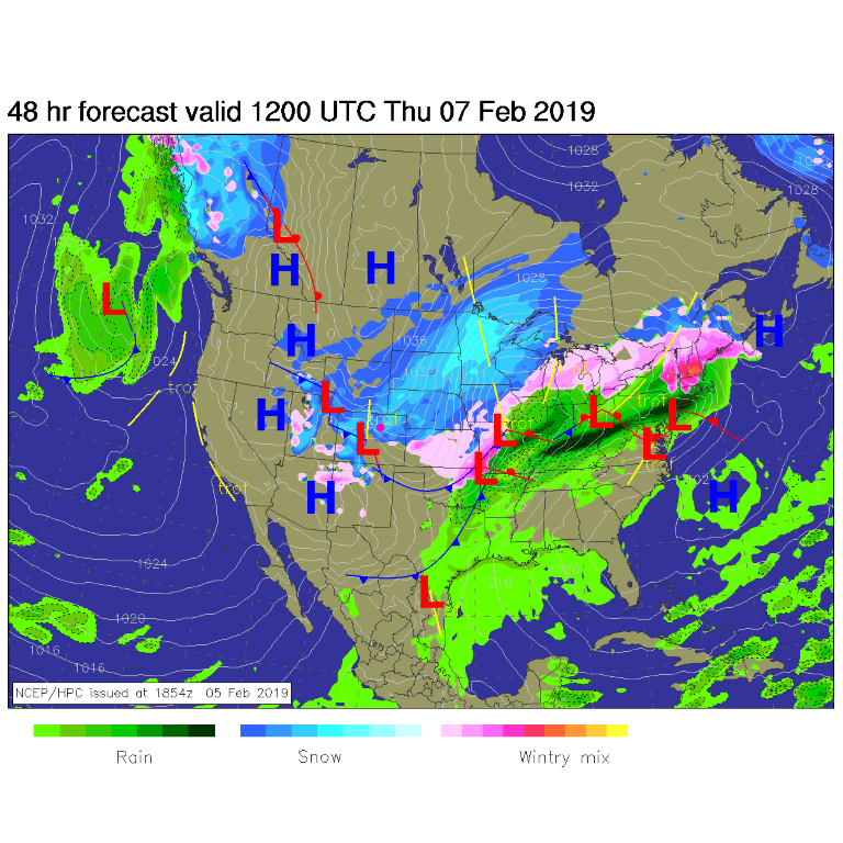
This IS a big, cold, windy, snowy mess moving in. Prepare your outdoor pets/hoses/campers/plants - anything that the warm weather lulled you into putting outside. By Wednesday night, rain and snow from this system - in advance of the Arctic cold air flow - will stretch from coast to coast (Figure 1). Overnight into Thursday morning, significant snow will hit the northern and western parts of the state (Figure 2).
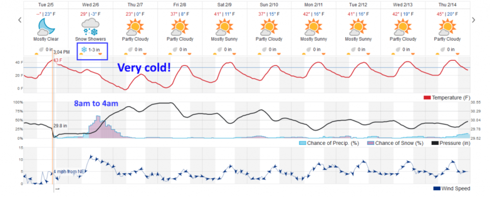
The graphical forecast from weatherunderground still shows 1-3 inches falling during almost 24 hours of a precipitation event from 8 am Wednesday to 4 am Thursday (give or take a few hours - often very cold air slips down the Front Range quicker than the models predict). After that (the Longer Range Forecast) we stay seasonally (or a bit below) normal as temperatures go and stay dry.
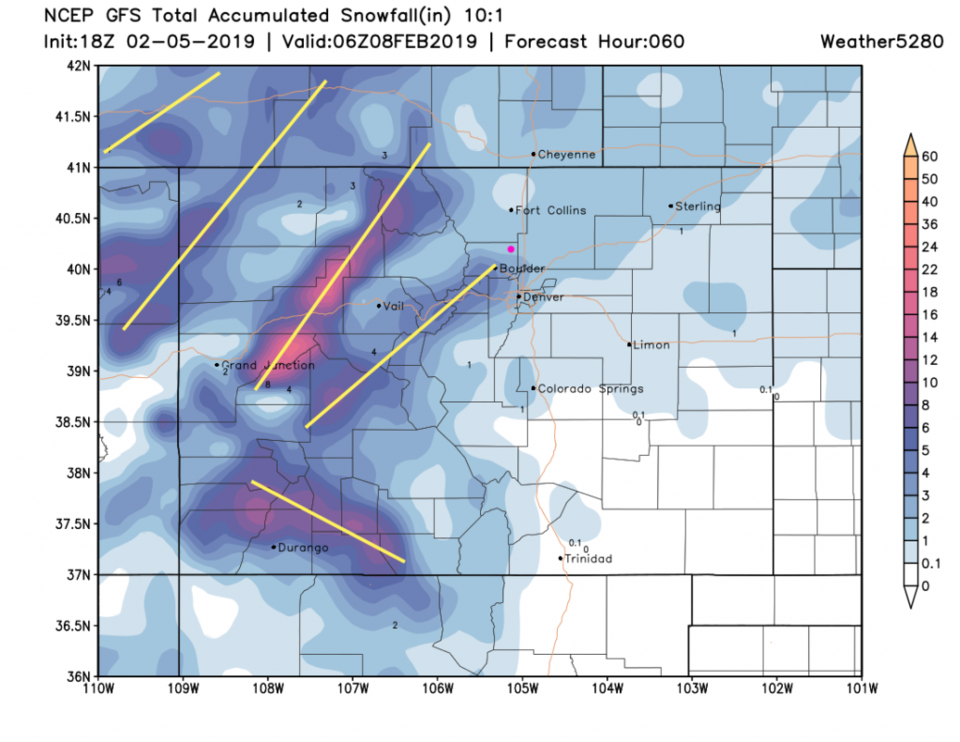
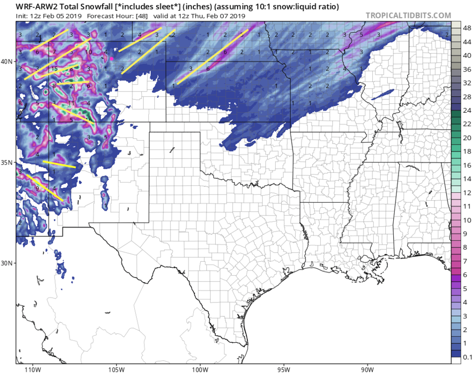
Back to our storm at hand: My forecast (acknowledging that snow banding (yellow lines in Figures 4, 5, and 6) may double the base snow amount wherever the bands set up in real life) is for Longmont to receive 2-5 inches (since the models keep putting a band over Boulder county).
We saw weatherunderground had 1-3 inches for this storm in Longmont.
The GFS (Figure 4) gives us 1-2 inches.
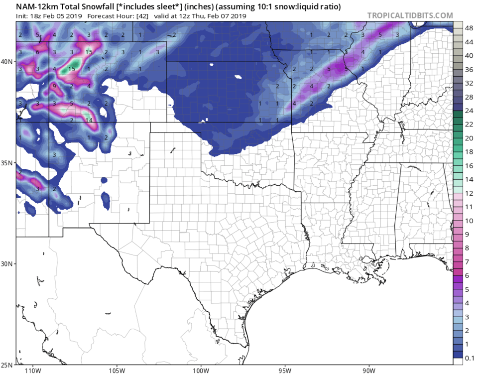
The NAM (Figure 5) gives us 3-4 inches.
The WRF (Figure 6) gives us 2-3 inches.
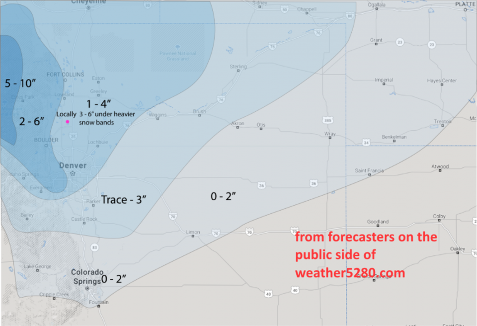
The forecasters at weather5280.com (Figure 7) have us painted in the 1-4 inch area with 3-6 inches possible where snow bands set up.
As temperatures drop through the 20's F and 10's F and enter single digits at the end of the precipitation event, snow ratios go way up. Fluffier snow will measure as deeper.
The winter weather advisory also correctly points out that the 10-20 mph winds will create dangerously cold wind chills (as if temperatures near 0°F are not cold enough). The NWS warns of wind chill temperatures approaching -25°F.
Stay safe out there. I'll update with warnings or watches or significant forecast changes as needed!
Figure 1: The forecast surface map for Wednesday PM. From NCEP.
Figure 2: The forecast surface map for Thursday AM. From NCEP.
Figure 3: the graphical forecast for the next 10 days for Longmont, CO from weatherunderground.com
Figure 4: the forecast accumulated snow map from the GFS and weather5280.com for Colorado, through Thursday late PM. Yellow lines are 'this run's' hint at snow bands.
Figure 5: the forecast accumulated snow map from the NAM on a wider view and tropicaltidbits.com for Colorado, through Thursday AM. Yellow lines are 'this run's' hint at snow bands.
Figure 6: the forecast accumulated snow map from the WRF on a wider view and tropicaltidbits.com for Colorado, through Thursday AM. Yellow lines are 'this run's' hint at snow bands.
Figure 7: The hand drawn forecast from the forecasters at weather5280.com published on the public post Tuesday afternoon.