Skip to content

Next Storm/Next Snow Forecast Discussion from the Cherrywood Observatory – July 3, 2019

This content was originally published by the Longmont Observer and is licensed under a Creative Commons license.

In Brief:

The forecast is becoming summer-simple: high temperatures around 90F each day with a greater or lesser chance of afternoon thunderstorms coming off the mountains. Our most stormy afternoons appear to be Tuesday (post day for this column) and Friday- Saturday. We do cool to the lower 80'sF briefly Saturday.

Forecast Discussion:

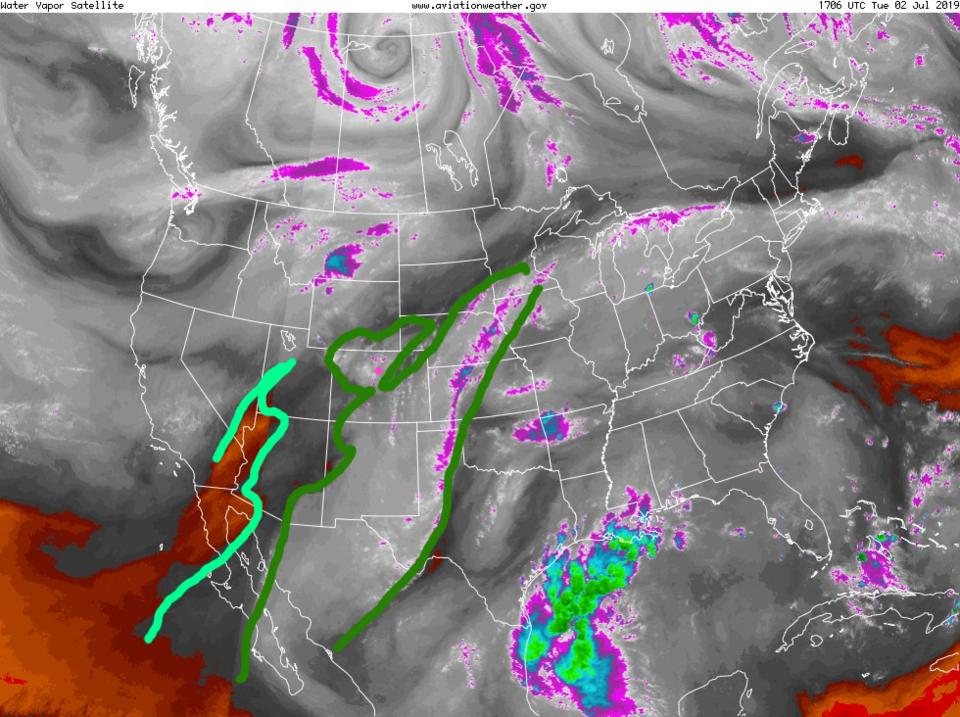
The dark green outline shows the deeper moisture (as it begins to move out of the state - Figure 1). The lighter green line outlines very dry air to our west. The chance of severe weather is marginal just north of Longmont up through Ft. Collins etc. (not shown).

The Longer Range Forecast:

We spend a few hours in the lower 90sF Wednesday and Thursday before we cool to the mid 80'sF then lower 80'sF Friday and Saturday. Afternoon storm chances are low, but still exist.

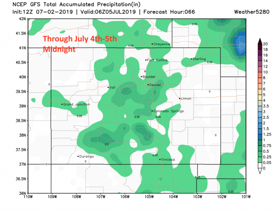
The 4th of July Forecast:

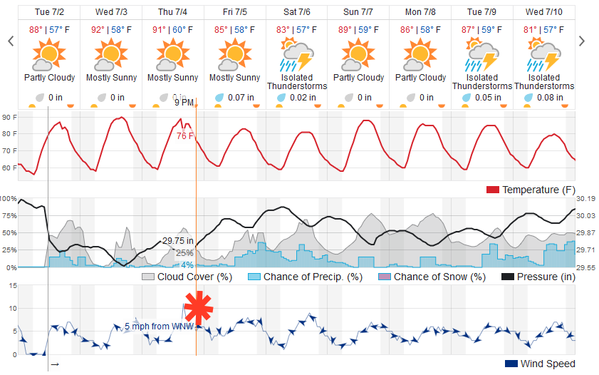
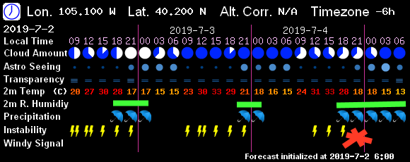
I have a red asterisks at about 9pm on the charts Figure 2 and Figure 3. The weatherunderground model has us at ab out 76F at 9pm with a 4% chance of showers and 25% cloud cover that is decreasing. The GFS based 7! Timer model (Figure 3) has us at about 63F with cloudy skies and showers occurring. It begins to clear after midnight. There is some clear disagreement - we'll keep an eye on it!

Figure 1: the water vapor satellite image (browns/reds are dry air, whites and light grey is moist air, purple/blue is ice and high cloud tops). From the NWS.
Figure 2: the graphical forecast for the next 10 days for Longmont, CO from weatherunderground.com
Figure 3: The 2.5 day sky conditions forecast from 7! Timer (the GFS).
Figure 4: the forecast accumulated precipitation map from the GFS and weather5280.com for Colorado, up to July 4th morning.
Figure 5: the forecast accumulated precipitation map from the GFS and weather5280.com for Colorado, up to July 4th late night.

Current Weather

Cloudy

Cloudy

33°F

UV Index
0 Low
Pressure
30.23 Steady
Visibility
7 miles
Dewpoint
29 °F
Humidity
87%
Wind
NE 3.2 mph
Gust
6 mph
Wind Chill
30 °F

Hourly Forecast

Today
6 AM
32°F
Cloudy
Today
7 AM
33°F
Cloudy
Today
8 AM
34°F
Cloudy
Today
9 AM
36°F
Cloudy
Today
10 AM
37°F
Flurries
Today
11 AM
38°F
Flurries
Today
12 PM
39°F
Cloudy
Today
1 PM
39°F
Flurries
Today
2 PM
41°F
Showers
Today
3 PM
41°F
Cloudy
Today
4 PM
42°F
Cloudy
Today
5 PM
43°F
Cloudy

7 Day Forecast

Rain and snow

Thursday

43 °F

Cloudy and chilly with a couple of showers of rain or snow


Mostly cloudy

Thursday Night

34 °F

Mostly cloudy


Mostly cloudy w/ showers

Friday

49 °F

Chilly with some sun, then turning cloudy; a little rain in the afternoon


Rain and snow

Friday Night

33 °F

Snow at times, accumulating an inch or two; rain mixed in early


Flurries

Saturday

46 °F

A bit of morning snow with little or no accumulation; otherwise, cloudy and chilly; storm total snowfall an inch or two


Intermittent clouds

Saturday Night

31 °F

Partly cloudy


Partly sunny

Sunday

69 °F

Warmer with partial sunshine


Partly cloudy

Sunday Night

44 °F

Partly cloudy


Mostly cloudy

Monday

77 °F

Mostly cloudy and warm


Intermittent clouds

Monday Night

41 °F

Partly to mostly cloudy


Sunrise and Sunset

Sunrise
6:17 AM
Sunset
7:43 PM

Based on AccuWeather data