Skip to content

The Forecast Discussion from the Cherrywood Observatory – May 25-27, 2020

This content was originally published by the Longmont Observer and is licensed under a Creative Commons license.

In Brief:

With northwest flow aloft for a bit longer, we have one more notable front this week. This front comes through Wednesday afternoon followed by showers overnight into Thursday. After that, we warm up to summer levels with afternoon storm chances. June 1st IS the beginning of meteorological summer (even if June 20th is the start of astronomical summer).

Forecast Discussion:

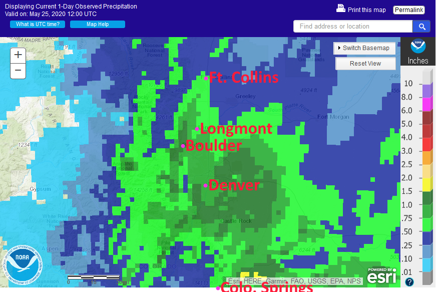
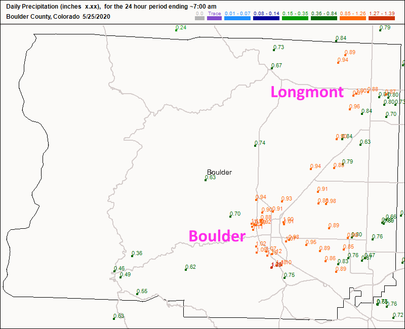
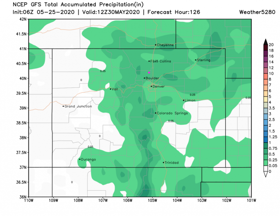
Let's look backwards before we look forwards. That was a very nice wet storm. Figure 1 shows the actual rainfall pattern for the storm - it matches the GFS's forecast very well. Denver, Boulder, and Colorado Springs were the big winners with over an inch of water. Looking at individual gauges in Boulder county, Longmont saw 0.70 to 1.00 inch across town. Boulder saw around an inch to 1.40 inch - Figure 2.

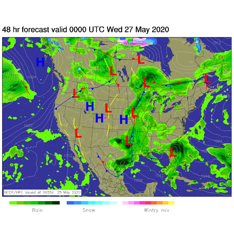
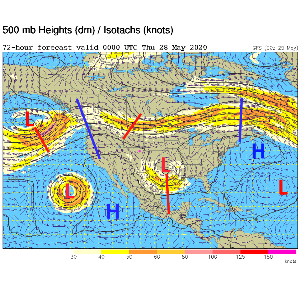
High pressure settles in for a couple of days (Figure 3) before...

The Longer Range Forecast:

There is one notable cool front coming in Wednesday afternoon. It will only shave about 5 degrees off of temperatures but brings in a chance of showers Wednesday night into Thursday AM. After that, we return to very warm temperatures (hovering around 90F) with afternoon storm chances. It will feel and look a lot like summer.

Note, if all goes well, this will be the last discussion on the Longmont Observer. The next forecast discussion should appear on the Longmont Leader.

Figure 1: the 1 day precipitation observations from NOAA for Colorado ending 7am Monday.
Figure 2 : 24 hour snowfall reports through 7am Monday in Boulder Co. from CoCoRaHS.
Figure 3: The forecast surface map for Tuesday PM from NCEP.
Figure 4: the graphical forecast for the next 10 days for Longmont, CO from weatherunderground.com
Figure 5: The 500mb forecast upper air analysis for Wednesday PM. Pink dot is Longmont. Red lines are troughs, blue lines are ridges.
Figure 6: precipitation totals through the next 5 days from the GFS and weather5280com for Colorado made Monday AM.

Current Weather

Light snow

Light snow

33°F

UV Index
0 Low
Pressure
30.27 Rising
Visibility
2 miles
Dewpoint
28 °F
Humidity
82%
Wind
NE 2.2 mph
Gust
3.9 mph
Wind Chill
33 °F

Hourly Forecast

Today
8 AM
34°F
Cloudy
Today
9 AM
36°F
Cloudy
Today
10 AM
37°F
Flurries
Today
11 AM
38°F
Flurries
Today
12 PM
39°F
Cloudy
Today
1 PM
39°F
Flurries
Today
2 PM
41°F
Showers
Today
3 PM
41°F
Cloudy
Today
4 PM
42°F
Cloudy
Today
5 PM
43°F
Cloudy
Today
6 PM
43°F
Cloudy
Today
7 PM
42°F
Cloudy

7 Day Forecast

Rain and snow

Thursday

43 °F

Cloudy and chilly with a couple of showers of rain or snow


Mostly cloudy

Thursday Night

34 °F

Mostly cloudy


Mostly cloudy w/ showers

Friday

49 °F

Chilly with some sun, then turning cloudy; a little rain in the afternoon


Rain and snow

Friday Night

33 °F

Snow at times, accumulating an inch or two; rain mixed in early


Flurries

Saturday

46 °F

A bit of morning snow with little or no accumulation; otherwise, cloudy and chilly; storm total snowfall an inch or two


Intermittent clouds

Saturday Night

31 °F

Partly cloudy


Partly sunny

Sunday

69 °F

Warmer with partial sunshine


Partly cloudy

Sunday Night

44 °F

Partly cloudy


Mostly cloudy

Monday

77 °F

Mostly cloudy and warm


Intermittent clouds

Monday Night

41 °F

Partly to mostly cloudy


Sunrise and Sunset

Sunrise
6:17 AM
Sunset
7:43 PM

Based on AccuWeather data