Skip to content
Join our Newsletter

Longmont Weather Forecast 6/10-11/2020

In Brief:

We rapidly warm up to above normal temperatures before the weekend and remain mostly dry for the next week. 

Forecast Discussion:

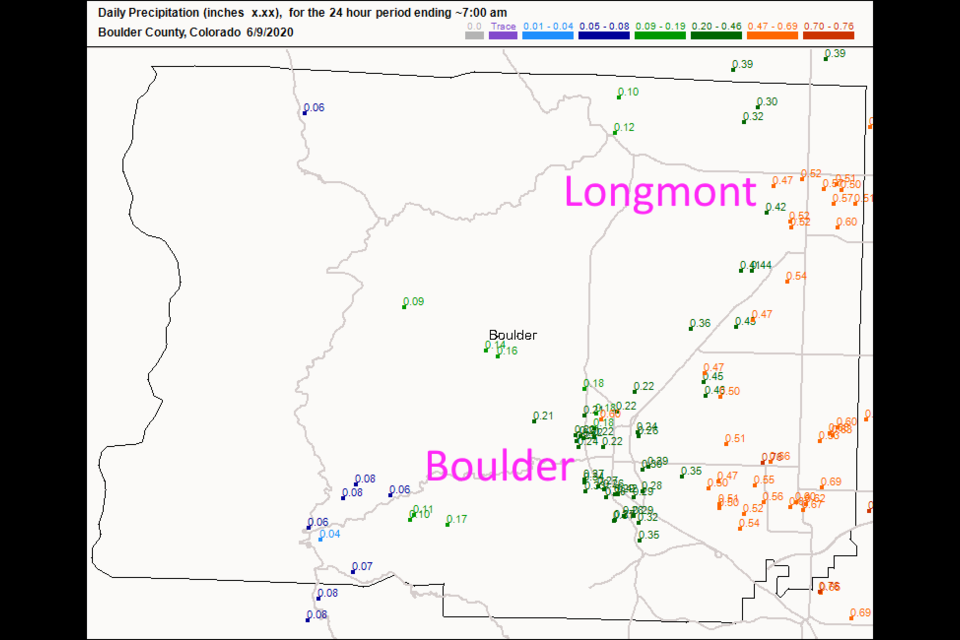
We had a vigorous cold front slam us with winds, cold air, and snow down to about 9000 feet elevation on Monday.  It was exciting. For rainfall, Longmont received about 1/2 to 2/3rds of an inch of rain where Boulder missed out a lot (Figure 1 in the gallery). You can see the progression of this abnormally cold air on Tuesday as it pushed out onto the Great Plains (Figure 2).  By Thursday, we are getting warm and dry with high pressure at the surface (Figure 3) and a big ridge overhead (Figure 4).  Forget rain and cool temperatures for the next week and more.

The Longer Range Forecast:

By Saturday, the ridge still dominates the middle of the country with southwest flow aloft over our state (Figure 5). The ridge is really tipped over with troughs passing the state to the north by the start of next week (Figure 6) - but we are still warm/hot and dry in the long term.

Over the next 5 days, random showers (I'm doubtful this much water will fall) may give us a trace to a 1/10th inch (Figure 7).  Over the next 10 days, we maybe add another 1/10th inch, on average, around Longmont (Figure 8).  More on storms we can't yet see in a future post! Stay cool.

The video forecast from LPM.


About the Author: John Ensworth

John Ensworth used to work from Longmont as the PI for the NASA through the IGES (The Institute for Global Environmental Strategies). He now teaches technology, algebra, astronomy, meteorology, film school, and Lego robotics to middle/high school.
Read more


Comments


Current Weather

Sunny

Sunny

88°F

UV Index
10 Very High
Pressure
30.14 Steady
Visibility
8 miles
Dewpoint
56 °F
Humidity
33%
Wind
ESE 2.4 mph
Gust
5.1 mph
Wind Chill
88 °F

Hourly Forecast

Today
1 PM
90°F
Partly sunny
Today
2 PM
92°F
Mostly cloudy
Today
3 PM
93°F
Mostly cloudy
Today
4 PM
91°F
Mostly cloudy
Today
5 PM
87°F
Mostly cloudy
Today
6 PM
83°F
Thunderstorms
Today
7 PM
80°F
Mostly cloudy
Today
8 PM
77°F
Partly sunny
Today
9 PM
73°F
Partly cloudy
Today
10 PM
71°F
Partly cloudy w/ t-storms
Today
11 PM
68°F
Partly cloudy
Tomorrow
12 AM
67°F
Partly cloudy

7 Day Forecast

Mostly cloudy w/ t-storms

Monday

93 °F

A shower in spots late this morning, then a thunderstorm in spots late this afternoon; thunderstorms can bring hail and damaging winds


Partly cloudy w/ t-storms

Monday Night

60 °F

A thunderstorm in spots this evening; otherwise, clear to partly cloudy; thunderstorms can bring hail and damaging winds


Intermittent clouds

Tuesday

96 °F

Intervals of clouds and sunshine


Partly cloudy

Tuesday Night

61 °F

Partly cloudy


Partly sunny w/ t-storms

Wednesday

82 °F

Clouds and sun with a thunderstorm in the afternoon; thunderstorms can bring hail and damaging winds


Partly cloudy w/ t-storms

Wednesday Night

58 °F

An evening thunderstorm; otherwise, partly cloudy


Mostly cloudy

Thursday

86 °F

Mostly cloudy with a thunderstorm in spots in the afternoon


Partly cloudy

Thursday Night

58 °F

Partly cloudy


Mostly cloudy

Friday

89 °F

Variable cloudiness


Mostly clear

Friday Night

61 °F

Mainly clear


Sunrise and Sunset

Sunrise
5:43 AM
Sunset
8:29 PM

Based on AccuWeather data