Skip to content
Join our Newsletter

Longmont Weather Forecast 6/16-17/2020

In Brief:

A cold front (and trough aloft) kills our current heatwave starting Wednesday afternoon bringing two days of cool weather and rain before the warmth returns again.

Forecast Discussion:

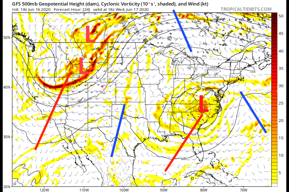
Here comes our trough and relief.  It is traveling towards Colorado as I type (Figure 1 in the gallery). The surface front is rapidly approaching the Front Range midday Wednesday (Figure 2). The cold front will hit Longmont around 3-5pm (Figure 3) ushering in a very remarkable cool down again; expect about a 20F drop in temperatures.  That front has crossed the entire state by Thursday morning (Figure 4). Moisture is flowing back in from the Gulf of Mexico Thursday PM (Figure 5). Over the two day rainy cold spell (with occasional thunderstorms) we might see about 1/2 inch of water around town (Figure 6).

As this system approaches, we still have smoke and haze from Arizona and SW Colorado forest fires pouring into the state (Figure 7) on southwest winds. It isn't until the front sweeps down and north winds return do we see the air clear (Figure 8) later Wednesday night.

The Longer Range Forecast:

A ridge slowly returns (Figure 9) warming us to the 80'sF over the weekend (Figure 3) and 90'sF again next week. Another trough and smaller cool down may return Wednesday (Figure 3).  Enjoy this nice break in summer.  (We are racking up a remarkable number of 90F+ days already this year.  We'll compare this with previous years in future posts.)

Forecast Video for the week beginning June 17th, 2020


About the Author: John Ensworth

John Ensworth used to work from Longmont as the PI for the NASA through the IGES (The Institute for Global Environmental Strategies). He now teaches technology, algebra, astronomy, meteorology, film school, and Lego robotics to middle/high school.
Read more


Comments


Current Weather

Cloudy

Cloudy

50°F

UV Index
0 Low
Pressure
29.68 Steady
Visibility
8 miles
Dewpoint
41 °F
Humidity
72%
Wind
WNW 1.6 mph
Gust
5.2 mph
Wind Chill
50 °F

Hourly Forecast

Today
2 AM
49°F
Showers
Today
3 AM
49°F
Cloudy
Today
4 AM
48°F
Cloudy
Today
5 AM
48°F
Cloudy
Today
6 AM
47°F
Cloudy
Today
7 AM
50°F
Cloudy
Today
8 AM
53°F
Intermittent clouds
Today
9 AM
56°F
Intermittent clouds
Today
10 AM
59°F
Intermittent clouds
Today
11 AM
62°F
Intermittent clouds
Today
12 PM
64°F
Intermittent clouds
Today
1 PM
64°F
Intermittent clouds

7 Day Forecast

Thunderstorms

Sunday

64 °F

Overcast and cooler; breezy in the afternoon with showers and gusty thunderstorms; thunderstorms can bring flooding downpours, hail and damaging wind gusts


Thunderstorms

Sunday Night

47 °F

Cloudy; a thunderstorm in parts of the area in the evening followed by a shower in spots late


Intermittent clouds

Monday

64 °F

Times of clouds and sun


Cloudy

Monday Night

40 °F

Cloudy


Mostly cloudy

Tuesday

72 °F

Cloudy in the morning, then intervals of clouds and sunshine in the afternoon


Mostly clear

Tuesday Night

44 °F

Mainly clear


Mostly sunny

Wednesday

78 °F

Mostly sunny and nice


Mostly clear

Wednesday Night

42 °F

Mainly clear


Mostly sunny

Thursday

77 °F

Sunny to partly cloudy and delightful


Clear

Thursday Night

48 °F

Clear


Sunrise and Sunset

Sunrise
5:42 AM
Sunset
8:12 PM

Based on AccuWeather data