Skip to content

Update 6/3 10am: Longmont Weather Forecast 6/2-3/2020

In Brief:

Very warm temperatures are the rule for the next week with daily (low) chances of thunderstorms in the afternoon/ early evening.

Update 6/3 10am:

The dryline is expected to set up many 10's of miles east of Longmont.  Severe weather/thunderstorm will form out on the Plains and move away to the east. Really warm weather continues.

The tropical system in the Gulf has developed into a tropical storm Cristobal.  It is forecasted to remain a tropical storm as it travels up to the central Louisiana coast for a pre-dawn landfall on Monday (Figure 1 update).  

End 6/3 10am update.

Forecast Discussion:

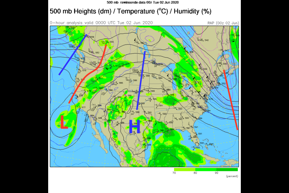
Figure 1 in the gallery shows the giant ridge dominating the center of the nation.  I saw one neighborhood station reach 99F on Monday. Wow! That ridge won't go far. The white and grey shades in the water vapor satellite image show that we have moisture in place across the state (Figure 2).  There is moisture flowing in from the Pacific and the Gulf of Mexico. A weak front will keep drifting back and forth across the state giving us a focus for convection in the afternoons when heating is at a maximum (Figure 3). As we hover around 90F - we'll have a (low) chance of thunderstorms every afternoon (Figure 4). 

The Longer Range Forecast:

That front, along with a short wave in the upper air flow will bring severe weather chances almost back to I-25 on Wednesday (primarily for large hail and high winds, Figure 5). Over the next 5 days, the central mountain and far northeastern corner of Colorado will see good rains.  Longmont should remain below 1/2 inch on average (Figure 6).  We finally see a cool down around Tuesday the 9th. This comes as a trough finally begins to displace the ridge next week (Figure 7). Stay cool out there. 

Video Forecast from Longmont Public Media


About the Author: John Ensworth

John Ensworth used to work from Longmont as the PI for the NASA through the IGES (The Institute for Global Environmental Strategies). He now teaches technology, algebra, astronomy, meteorology, film school, and Lego robotics to middle/high school.
Read more


Comments


Current Weather

Cloudy

Cloudy

34°F

UV Index
0 Low
Pressure
30.27 Steady
Visibility
3 miles
Dewpoint
31 °F
Humidity
88%
Wind
NNE 4.4 mph
Gust
7.1 mph
Wind Chill
30 °F

Hourly Forecast

Today
6 PM
36°F
Rain
Today
7 PM
36°F
Rain
Today
8 PM
36°F
Cloudy
Today
9 PM
36°F
Flurries
Today
10 PM
36°F
Cloudy
Today
11 PM
36°F
Rain and snow
Tomorrow
12 AM
36°F
Rain and snow
Tomorrow
1 AM
35°F
Cloudy
Tomorrow
2 AM
35°F
Snow
Tomorrow
3 AM
34°F
Flurries
Tomorrow
4 AM
34°F
Snow
Tomorrow
5 AM
33°F
Snow

7 Day Forecast

Rain and snow

Friday

41 °F

Chilly; rain and snow showers this morning with little or no accumulation followed by rain and drizzle this afternoon


Rain and snow

Friday Night

33 °F

Periods of snow; rain mixed in early, accumulating 1-3 inches; roads could be slippery


Flurries

Saturday

39 °F

A bit of morning snow with little or no accumulation; otherwise, cloudy and cold; storm total snowfall 1-3 inches


Intermittent clouds

Saturday Night

30 °F

A shower in places in the evening; otherwise, partly cloudy


Partly sunny

Sunday

64 °F

Partly sunny and warmer


Mostly clear

Sunday Night

41 °F

Mainly clear


Intermittent clouds

Monday

79 °F

Warmer with a blend of sun and clouds


Partly cloudy

Monday Night

40 °F

Partly cloudy


Mostly cloudy

Tuesday

66 °F

Mostly cloudy and not as warm


Mostly cloudy

Tuesday Night

40 °F

Mostly cloudy


Sunrise and Sunset

Sunrise
6:15 AM
Sunset
7:44 PM

Based on AccuWeather data