Skip to content
Join our Newsletter

Longmont Weather Forecast 6/29-30/2020

In Brief:

Heat is interrupted by a passing trough Tuesday/Wednesday to be replaced by days of above normal heat again with daily thunderstorm chances.

Forecast Discussion:

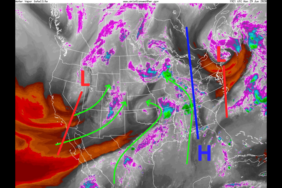
No large scale storms are in the offing, but there is a fair amount of (mainly) Pacific moisture in place across our region (Figure 1 in the gallery). Daily afternoon storms, forming in the mountains and wandering eastward, will be the rule.  For Tuesday/Wednesday, a trough passes the state (with most of the cold air aloft remaining north of Colorado (Figure 2)).  This will cool us to normal temperatures and enhance the afternoon storm chances a bit (green circle Figure 3). The fires in the southwest are are being brought under control so we are seeing much less smoke/haze around northern Colorado (Figure 4). Rainfall, according to the GFS, is very light and spotty over the next 5 days (Figure 5).

The Longer Range Forecast:

By Thursday, a ridge reestablishes itself over the West. By Saturday the entire nation is under a ridge coast to coast (Figure 6). We return to high temperatures in the mid 90'sF most days with afternoon storm chances (Figure 3).  Unfortunately, fire weather conditions will be elevated and these storms might produce some lightning sparked fires.

Independence Day:

We will have a big ridge over most of the U.S. for Independence Day with high in the lower 90'sF and a fair chance of an afternoon thunderstorm. Summer and typical 4th of July weather.


About the Author: John Ensworth

John Ensworth used to work from Longmont as the PI for the NASA through the IGES (The Institute for Global Environmental Strategies). He now teaches technology, algebra, astronomy, meteorology, film school, and Lego robotics to middle/high school.
Read more


Comments


Current Weather

Mostly cloudy

Mostly cloudy

55°F

UV Index
2 Low
Pressure
29.76 Steady
Visibility
8 miles
Dewpoint
47 °F
Humidity
76%
Wind
NNW 2.3 mph
Gust
4.5 mph
Wind Chill
55 °F

Hourly Forecast

Today
9 AM
57°F
Mostly cloudy
Today
10 AM
60°F
Mostly cloudy
Today
11 AM
62°F
Mostly cloudy
Today
12 PM
64°F
Cloudy
Today
1 PM
64°F
Cloudy
Today
2 PM
64°F
Cloudy
Today
3 PM
64°F
Cloudy
Today
4 PM
61°F
Thunderstorms
Today
5 PM
58°F
Cloudy
Today
6 PM
57°F
Cloudy
Today
7 PM
57°F
Mostly cloudy
Today
8 PM
55°F
Intermittent clouds

7 Day Forecast

Mostly cloudy w/ t-storms

Sunday

64 °F

Cooler with variable clouds; breezy this afternoon with showers and a heavier t-storm; thunderstorms can bring flooding downpours, hail and damaging wind gusts


Mostly cloudy w/ t-storms

Sunday Night

47 °F

A thunderstorm on the prowl this evening; otherwise, increasing clouds


Intermittent clouds

Monday

65 °F

Times of clouds and sun


Cloudy

Monday Night

40 °F

Cloudy


Mostly cloudy

Tuesday

72 °F

Cloudy in the morning, then intervals of clouds and sunshine in the afternoon


Mostly clear

Tuesday Night

44 °F

Mainly clear


Mostly sunny

Wednesday

78 °F

Mostly sunny and nice


Mostly clear

Wednesday Night

42 °F

Mainly clear


Mostly sunny

Thursday

77 °F

Mostly sunny


Mostly clear

Thursday Night

48 °F

Mainly clear


Sunrise and Sunset

Sunrise
5:42 AM
Sunset
8:12 PM

Based on AccuWeather data