In Brief:
Heat and residual moisture will give us afternoon storm chances into the weekend when things dry out and cool down at the start of next week.
Update 6/5 9am:
We will approach 100F today (it will probably hit 95-97F) with the big ridge in place. The west coast trough will be making its move tomorrow bringing widespread thunderstorm activity to most of the state Saturday. There is a marginal risk (1 on a scale of 1-5) of severe weather - hail, high winds (and lightning of course) for all of western Colorado and northern counties. For Longmont, peak storm activity should occur between 11am and 5pm as the trough passes. There is a slight risk around Ft. Collins and north (Figure 1 update). It is possible that the higher risk area will be expanded tonight or by the morning. Keep an eye on the https://www.spc.noaa.gov/ site and your favorite weather apps for updates.
John's favorite weather alert apps: RainAware, Dark Sky, Storm Shield, Weather Bug, My favorite radar apps are MyRadar and RadarScope.
There is now a tropical storm watch issued for New Orleans, LA. Cristobal is still predicted to remain below hurricane intensity, but heavyt rainfall, storm surge, and flooding is possible for ares along the Gulf Coast near New Orleans. Landfall is expected late Sunday night early Monday morning (Figure 2 update). I don't think we need any more big news... here's to hoping for minimal impact.
End 6/5 9am update.
Forecast Discussion:
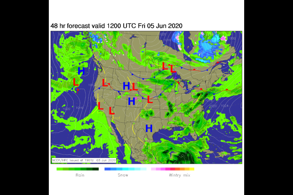
Surface high pressure and fading moisture will slowly tap down storm chances each day (Figure 1 in the gallery). Aloft, a very strong high pressure ridge is in place and won't budge until later in the weekend (Figure 2). Temperatures will be 10-20 degrees F above normal from Nevada to the east coast (Figure 3). Note that the blue (cool) blobs in Figure 3 are cool air dumped by afternoon thunderstorms in the model.
The Longer Range Forecast:
We have small chances of thunderstorms with lighting through Saturday afternoon (Figure 4). Sunday will be quite warm and dry as the ridge prepares to depart. Sunday night into Monday, the western trough makes its move eastward and we begin our cool down (Figure 5). Temperatures will be (briefly) below normal Tuesday next week (Figure 4).
A Final Look at Snow:
Historically, our latest trace of snow came in the first weeks of June ( June 12, 1947 - Trace and last measurable snow was on June 2, 1951 - 0.3" ). I thought it would be good take a last glance at the snow pack. We ended up below normal (at 50%) of our water content for the state still locked in the snow pack (Figure 6). Things DID get warm recently. In our watershed, we are at 40% normal going into the summer (Figure 7).
One more thing, the tropics:
Tropical Storm Cristobal is still headed for a late Sunday night landfall in Louisiana. It is still not expected to become a hurricane, but it will get close to that strength. This system will probably not send any moisture/moist air towards Colorado because of the approaching trough late this weekend.

