In Brief:
Rain and a few thunderstorms will dump about a quarter of an inch of water across the region Monday PM into Tuesday AM, then we return to dry abnormally warm weather for the next week and beyond.Forecast Discussion:
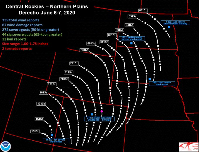
Saturday was interesting. The National Weather Service officially declared that the line of thunderstorms that swept the state was a phenomena called a Derecho (Figure 1 in the gallery). A Derecho (which comes from the Spanish word for straight or direct) can be defined as: a thunderstorm complex that produces a damaging wind swath of at least 400 km (250 miles), featuring a concentrated area of convectively-induced wind gusts exceeding 30 m/s (90 km/h; 50 kn; 60 mph). According to the National Weather Service (NWS) criterion, a derecho is classified as a band of storms that have winds of at least 30 m/s (90 km/h; 50 kn; 60 mph) along the entire span of the storm front, maintained over a time span of at least six hours. (Wikipedia). The wind reports are really impressive (Figure 2). Historically, this is VERY rare for Colorado and may be the first for the state since records have been kept. Thunderstorm speeds may have topped 110-120mph as they moved from Utah into Colorado. There was a 110mph wind gust at the top of the Winter Park sky area. Crazy. The rainfall from the event wasn't too bad either with Longmont receiving 0.10 to 0.25 inch of water (Figure 3).
Our next storm rolls in Monday (today) with a rapidly approaching deep trough in the upper air pattern (red line in Figure 4). The more narrow the trough (shorter wavelength) the quicker the system moves west to east. This will push a cold front down across Colorado today (Figure 5). By morning, upslope flow behind the front will allow rain and a few thunderstorms to wet our state (Figure 6) from mainly 5pm Monday to 7am Tuesday (Figure 7). Weatherunderground is calling for, roughly, another quarter of an inch of water (Figure 7). The GFS gives us between 0.10 and 0.25 inch of water (very similar to Saturday- just without the winds). Tuesday will be quite chilly with north winds behind the front. (There will be 3 to 9 inches of snow beginning after 9pm tonight in the higher mountains and western facing slopes mainly above 10,000 feet.)
A final check on Christobal: the tropical system in the Gulf did remain below hurricane strength as predicted but came ashore in Louisiana early, early afternoon Sunday. It is tracking inland and dumping its load of water. Widespread flooding has occurred and will occur from New Orleans northward (Figure 5 and 6).
The Longer Range Forecast:
The long range story is very simple. A big ridge parks itself over the West (Figure 9, from Thursday for example) and we warm up to above normal levels with dry conditions most of the time.

