The video forecast for the week begining 9/15/2020.
In Brief:
A big ridge aloft will settle in for a long stretch of summer while moisture in the lower atmosphere will allow daily thunderstorms to roll by every afternoon (mostly).
Update 7/3 11am:
A bit more moisture is flowing into the state. Watch for afternoon storm coverage to increase for the next few days. Figure 1 update in the gallery above shows thunderstorms forming in the evening over all of the Colorado Rockies. These will move to the east adding lightning to the moon lit sky and the fireworks that are going off. Stay dry, watch out for lighting!
There IS a marginal risk (1 on a scale of 1-5) just about 10-25 miles east of I-25 Friday and Saturday (and eastward out on the Plains). The SPC is placing the I-25 cities under a marginal risk Sunday, the main threat is for hail and high winds.
End 7/3 11am update.
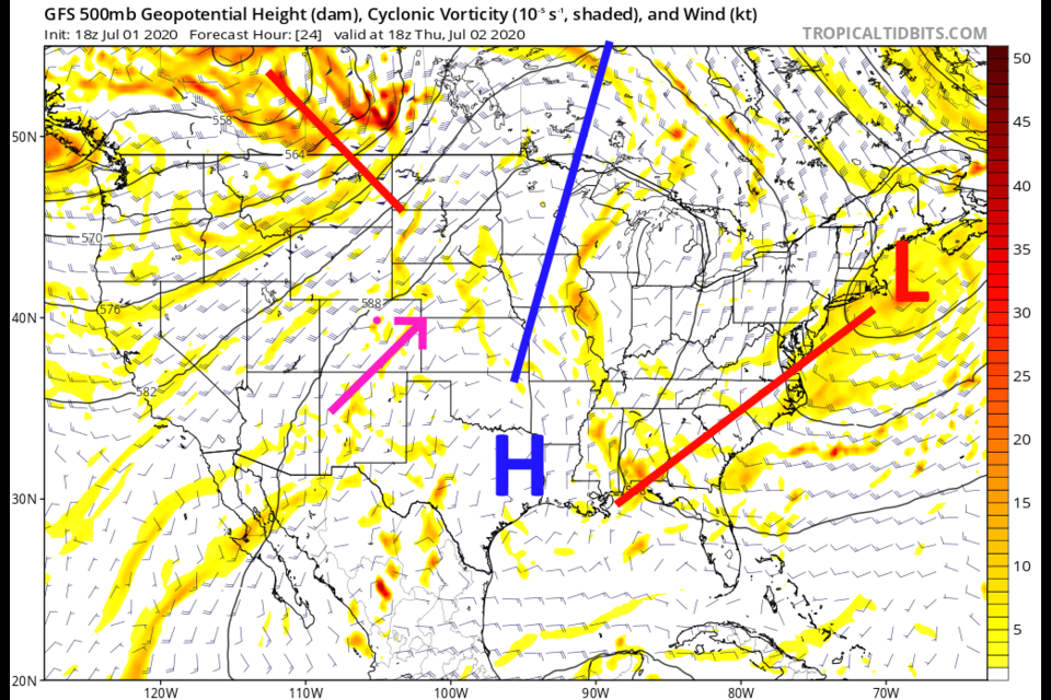
Forecast Discussion:
Here comes the ridge. Starting this forecast period the ridge has migrated to a Texas to Minnesota line with southwest flow aloft over Colorado (Figure 1 in the gallery). There are still some fire activity in northern Arizona that will send a cloud of smoke over northeast Colorado Thursday (Figure 2 and 3). With no moisture around Thursday, it will be hot and dry.
The Longer Range Forecast:
For the next 10 days we have highs that remain in the 90'sF. Moisture feeds back into the state beginning Friday (Figure 4). Daily thunderstorm chances continue for the next week. By Saturday and Sunday, the ridge axis is draped across our state with weak north winds that will lower the highs to around 90-91F over the weekend (Figure 5). The abnormal amounts of atmospheric moisture is pooling nicely over the state for the weekend giving us better thunderstorm coverage around the region (Figure 6).
This pattern will hold for a LONG time. Looking all the way out to NEXT Saturday (July 11th), the ridge is dominating the entire nation west to east with western flow aloft over northern Colorado (Figure 7). There is still a good amount of low level moisture east of the Rockies that far out (Figure 8). For the next 5 days, unless a lucky thunderstorm crosses Longmont, we shouldn't see more than minimal rainfall amounts (Figure 9). Note: with this ridge growing across the country, look for heat wave news stories and lots of complaining people spending more time outside (sidewalk tables?!).

