Skip to content
Join our Newsletter

Longmont Weather Forecast 7/15-17/2020

In Brief:

Monsoon moisture is back giving us seasonably warm weather into the weekend with daily afternoon thunderstorm chances.

Forecast Discussion:

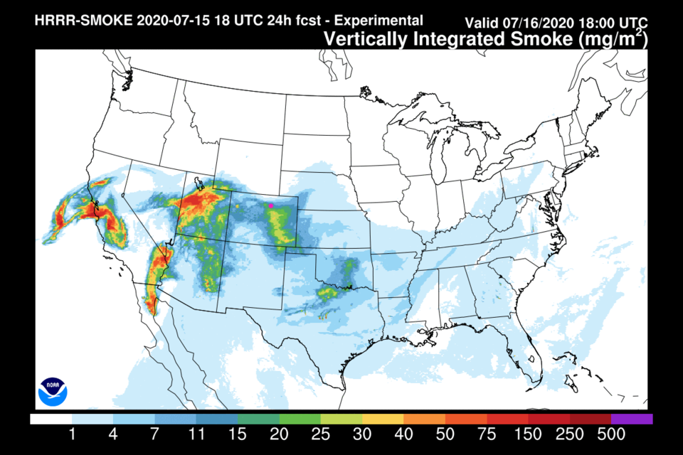
There are ongoing fires (and new ones) in the west.  Flow around the high pressure system to our southeast is bringing some of that smoke in creating hazy conditions and air quality alerts (Figure 1 in the gallery above). We are in a different kind of broken record pattern - one that is nicer and cooler than last week (what's a record Dad?).  We are hovering around 90F into the weekend with afternoon storm chances (green circles Figure 2). Our storm chances (even if not great each day) are due to the moisture flowing up into the state west of the high pressure center in Texas (green arrows Figure 3). The National Weather Service is calling this "monsoon moisture" - which is a seasonal air flow pattern that sets up in the summer in the Southwest U.S. The term is borrowed from the much more serious monsoon seen in India.

The Longer Range Forecast:

The pattern does not changed much at all even by Thursday (Figure 4).  Sadly, our five day precipitation total is still light in northern Colorado (Figure 5).  Lucky folks will see an inch or two of water in places (Figure 5). The pattern is expected to change by next Wednesday (Figure 2) as the large east-west ridge across the southern U.S. forms another center around Las Vegas (Figure 6).  This will alter the air flow into the state, decrease our moisture availability, and bring back the heat for a while.

The Video Forecast for this Week!


About the Author: John Ensworth

John Ensworth used to work from Longmont as the PI for the NASA through the IGES (The Institute for Global Environmental Strategies). He now teaches technology, algebra, astronomy, meteorology, film school, and Lego robotics to middle/high school.
Read more


Comments


Current Weather

Mostly cloudy

Mostly cloudy

91°F

UV Index
6 High
Pressure
30.07 Falling
Visibility
8 miles
Dewpoint
49 °F
Humidity
24%
Wind
N 3.5 mph
Gust
7.8 mph
Wind Chill
91 °F

Hourly Forecast

Today
2 PM
90°F
Intermittent clouds
Today
3 PM
88°F
Partly sunny
Today
4 PM
87°F
Partly sunny
Today
5 PM
87°F
Partly sunny
Today
6 PM
84°F
Partly sunny
Today
7 PM
81°F
Partly sunny w/ t-storms
Today
8 PM
79°F
Partly sunny w/ t-storms
Today
9 PM
76°F
Mostly clear
Today
10 PM
73°F
Mostly clear
Today
11 PM
71°F
Clear
Tomorrow
12 AM
69°F
Clear
Tomorrow
1 AM
67°F
Clear

7 Day Forecast

Partly sunny w/ t-storms

Friday

92 °F

Partly sunny with a thunderstorm in spots this afternoon


Partly cloudy w/ t-storms

Friday Night

63 °F

A thunderstorm in spots early this evening; otherwise, partly cloudy


Partly sunny w/ t-storms

Saturday

92 °F

Partly sunny with a thunderstorm in spots in the afternoon


Partly cloudy

Saturday Night

62 °F

Partly cloudy


Mostly cloudy w/ t-storms

Sunday

93 °F

Variable cloudiness with a thundershower in spots in the afternoon


Mostly cloudy

Sunday Night

62 °F

Increasing cloudiness


Mostly cloudy

Monday

93 °F

Mostly cloudy


Mostly clear

Monday Night

64 °F

Clear to partly cloudy


Intermittent clouds

Tuesday

92 °F

Intervals of clouds and sun


Intermittent clouds

Tuesday Night

62 °F

Partly cloudy


Sunrise and Sunset

Sunrise
5:46 AM
Sunset
8:27 PM

Based on AccuWeather data