In Brief:
A couple of cool fronts return us to normal temperatures (near 90F) with small daily afternoon storm chances continuing this week.
Update 7/19 1pm:
Moisture has pushed westward behind last night's cool front and has made it into the foothills. This, with good daytime heating and slow steering winds aloft mean that we'll have a chance of severe weather this afternoon along I-25 and for the entire eastern half of the state (Figure 1 update). The primary thread from these slow moving storms with gusty winds is large hail in spots (Figure 2 update). Keep an eye on the west-northwest skies for an approaching cell (with lighting as a normal but deadly threat as well).
End update 7/19 1pm.
Forecast Discussion:
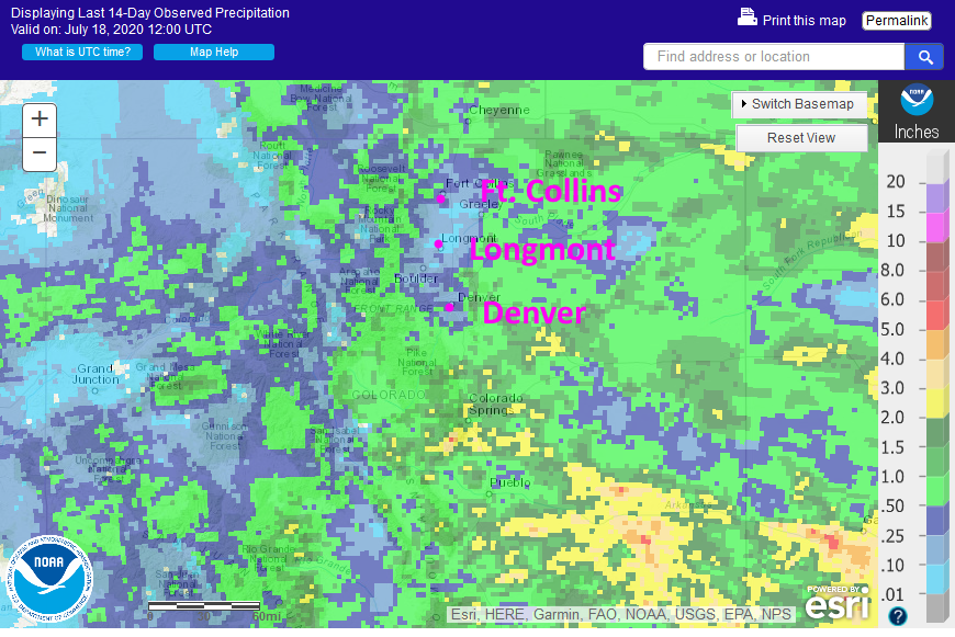
The last two weeks saw healthy rainfall amounts over 1/2 to 1 inch for most of eastern and southern Colorado (Figure 1 in the gallery). This is great news for those areas. The I-25 corridor from Denver to Ft. Collins missed out for the most part.
The national weather story revolives around the extended ridge of high pressure east to west across the southern states (Figure 2, blue H's). The jet stream and passing troughs are riding along at fairly high latitudes. The upper and mid-level moisture flow isn't entering the state as directly as it has (light green arrow in Figure 2) but low level moisture is still making its way in (dark green arrow). You can see this lower level moisture quite clearly in Figure 3. The trough passing to our north in Figure 2 and 3 is kicking down the first cool front later on Saturday (blue dashed line in Figure 5). This will increase moisture, lower temperatures a few degrees, and give us a small chance of afternoon storms (and maybe cloudy skies overnight).
The Longer Range Forecast:
Another trough passes Monday (Figure 4 and 5) cooling us a few degrees more and giving us a short period of north winds Monday (pink arrow Figure 4). Beyond Monday, we settle on high tempreatures just a bit above 90F with a daily small chance of afternoon storms. If you are lucky, you'll get rain now and then. Summer marches on!

