Skip to content
Join our Newsletter

Longmont Weather Forecast 5/31-6/1/2020

In Brief:

Severe weather chances are low, expect above normal temperatures this week with daily afternoon/evening thunderstorm chances.

Forecast Discussion:

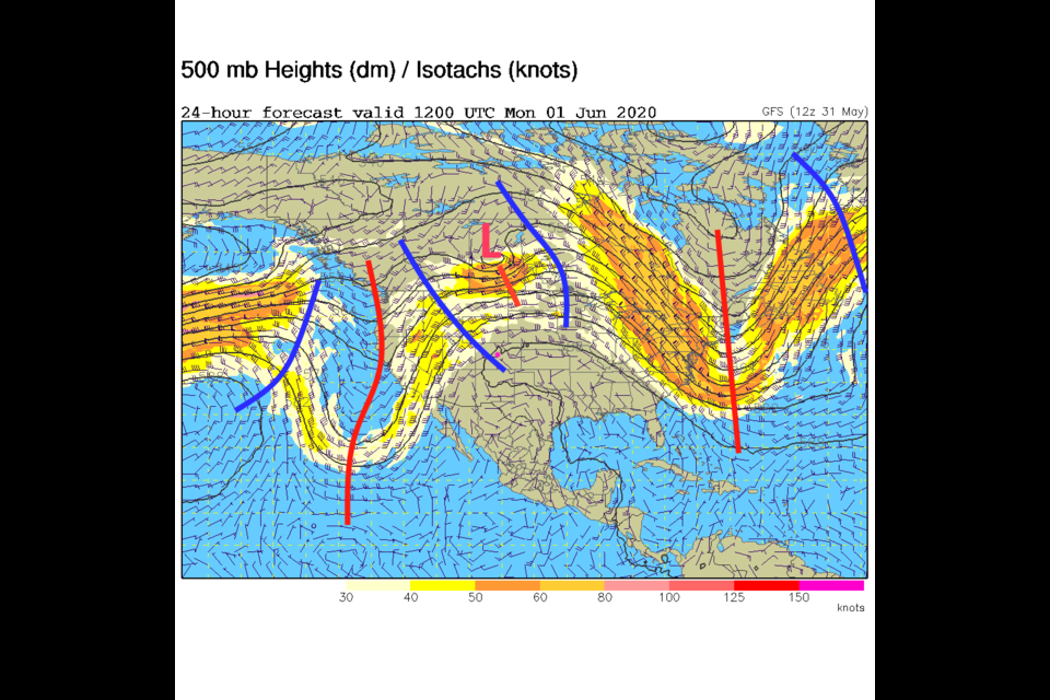
The dominate player on the field is the Western U.S. ridge (even if there is a small short wave/low traveling through it up in Canada Monday - Figure 1 in the gallery). It is creating daily temperatures that are quite a bit above normal.  We normally see a high of 77F right now.  We will be 10-12F warmer than that. Still, there there is pretty good moisture around.  The water vapor satellite image (Figure 2 in the gallery) shows that there IS a lot of moisture sitting around (white and grey colors across Colorado).  The amount of water that can precipitate out the atmosphere in an ideal situation (a healthy thunderstorm, for example) is pretty good as well. Figure 3 in the gallery shows moisture (green shading) has a nice fetch from both the Pacific and the Gulf of Mexico into Colorado.  Severe weather chances (not shown) should remain to the east and north of Longmont and most I-25 communities.

The Longer Range Forecast:

Over the next 5 days, we simply see hot temperatures and the daily pulse of afternoon/evening thunderstorms (Figure 4 in the gallery). A trough does begin to approach the state from Wednesday into Friday (Figure 5 in the gallery) leading to a better chance of thunderstorms by Friday afternoon (Figure 4).  Stay alert to lightning, that is the main risk each day.

The much Longer Range Forecast:

NOAA has issued the June outlook based on sea surface temperatures and model guidance. They are callling for normal (to maybe a touch above normal) temperatures for June (Figure 6 in the gallery) and near normal precipitatoin for the month (Figure 7 in the gallery). Normal is good, right?


About the Author: John Ensworth

John Ensworth used to work from Longmont as the PI for the NASA through the IGES (The Institute for Global Environmental Strategies). He now teaches technology, algebra, astronomy, meteorology, film school, and Lego robotics to middle/high school.
Read more


Comments


Current Weather

Clear

Clear

62°F

UV Index
0 Low
Pressure
30.02 Steady
Visibility
8 miles
Dewpoint
49 °F
Humidity
62%
Wind
WNW 2.2 mph
Gust
3.9 mph
Wind Chill
62 °F

Hourly Forecast

Today
4 AM
61°F
Clear
Today
5 AM
60°F
Clear
Today
6 AM
59°F
Sunny
Today
7 AM
63°F
Sunny
Today
8 AM
72°F
Sunny
Today
9 AM
80°F
Mostly sunny
Today
10 AM
87°F
Mostly sunny
Today
11 AM
91°F
Partly sunny
Today
12 PM
94°F
Intermittent clouds
Today
1 PM
96°F
Mostly cloudy
Today
2 PM
95°F
Mostly cloudy
Today
3 PM
92°F
Cloudy

7 Day Forecast

Intermittent clouds

Monday

94 °F

Some sun, then increasing clouds


Intermittent clouds

Monday Night

59 °F

Turning out clear


Intermittent clouds

Tuesday

96 °F

Very warm with intervals of clouds and sunshine


Partly cloudy

Tuesday Night

62 °F

Partly cloudy


Partly sunny w/ t-storms

Wednesday

80 °F

Times of sun and clouds with a thunderstorm in the afternoon; thunderstorms can bring hail and damaging winds


Partly cloudy w/ t-storms

Wednesday Night

59 °F

An evening thunderstorm; otherwise, partly cloudy


Mostly cloudy

Thursday

88 °F

Mostly cloudy with a thunderstorm in spots in the afternoon


Partly cloudy

Thursday Night

58 °F

Partly cloudy


Mostly cloudy

Friday

91 °F

Variable cloudiness


Partly cloudy

Friday Night

61 °F

Partly cloudy


Sunrise and Sunset

Sunrise
5:43 AM
Sunset
8:29 PM

Based on AccuWeather data