This content was originally published by the Longmont Observer and is licensed under a Creative Commons license.
By John Ensworth
Discussion:
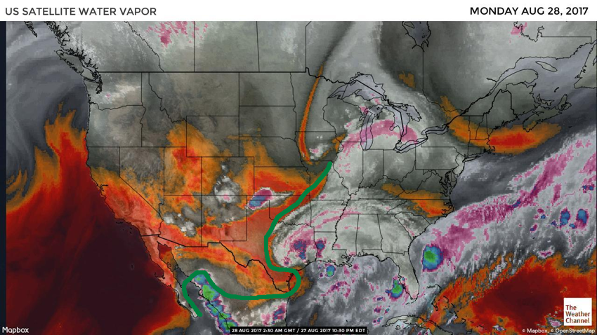
Nothing is going to change much. There is a stationary front draped down the Foothills that put cooler air across the Plains and Longmont. This cooler air stabilized the already not too moist (around 0.50” precipitatable water amounts) and not too unstable atmosphere (Figure 1). There is some smoke from the Pacific northwest making the sky a little milky in color rather than our normal deep blue riding in on the northwest flow. Figure 2 shows the really dry air across Colorado except just a bit of left over moisture in the mountains and down into the mountains of AZ and NM. The deep tropical moisture is outlined in green and is far far away. So quiet. Figure 3 shows the upper air pattern with our high center now anchored over the Great Basin and the big low associated with the remains of Hurricane Harvey in Texas.
Figure 1: The surface map from the Weather Channel for Sunday night.

Figure 2: The water vapor satellite image from Sunday night.

Figure 3: The 500mb forecast map for Monday morning from the GFS model.

In a look at the longer range:
What is scary for Texas is how little the overall pattern changes all week. We might see another cool front with the High shifting southwest around mid-week. Shortwaves might bring in a touch of moisture and instability locally, but it doesn’t really change all the way through next weekend. Figure 4 shows the upper air pattern for Saturday – it really looks a lot like the pattern for Sunday night. Figure 5 shows the surface rain chances for Saturday and it has oozed up into eastern Texas, but it is STILL raining on the coast.
Figure 4: The GFS forecasted upper air analysis for Saturday morning.

Figure 5: The GFS forecasted surface analysis for Saturday AM.

*** This feature will run as close to daily as possible in this location on the Longmont Observer. ***
This article will provide a brief discussion concerning the ‘why’ behind the weather with a focus on severe weather, unusual weather, and snow (especially trying to predict snow depth and its human impact in Longmont).
Bio:
John Ensworth works from Longmont as the Principle Investigator for the NASA Science Mission Directorate Earth and space science education product review through the IGES (The Institute for Global Environmental Strategies – www.strategies.org) . He is in his 14th year running this review. He is an astronomer (from the 2nd grade onward) and became a meteorologist (in the 5thgrade) when a thunderstorm in Arizona rained on his telescope when the weather service had only forecasted a 10% chance of rain. He has college degrees in physics and astronomy and climatology and a graduate degree in meteorology and earth science. He lectures at the Little Thompson Observatory in Berthoud, the Estes Park Memorial Observatory in Estes Park, and for a number of online universities. He built and runs a backyard observatory near Pace and 17th in northeast Longmont where he has lived for 8 years with his wife, daughter, son, and two cats. Invitations to open house nights at this observatory, LTO, and EPMO will be posted with future discussions when they are scheduled.
Forecasting severe weather and snow amounts via text lead to this column. He began texting friends about the weather right after the September 2013 flood. The readers of this column will, hopefully, keep him honest in what he ‘thought’ he had forecasted for ‘the most recent’ storm.

