Skip to content
Join our Newsletter

The Front Range Forecast: Afternoon storms some severe

In Brief:

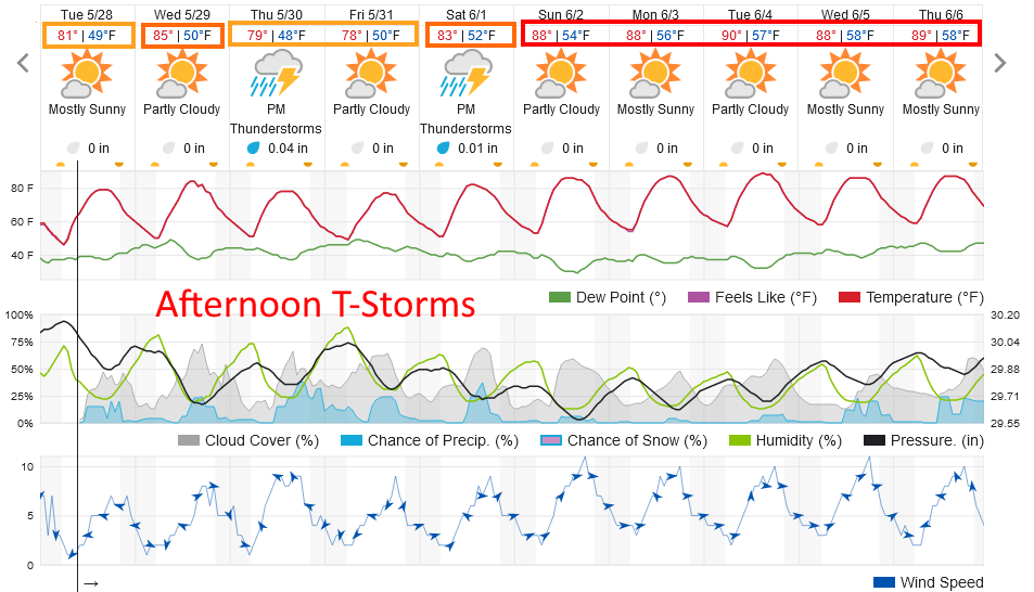
Afternoon thunderstorms return, some severe. Summer heat next week.

The Forecast Discussion:

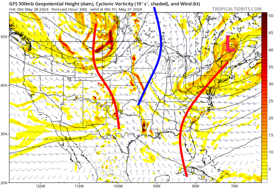
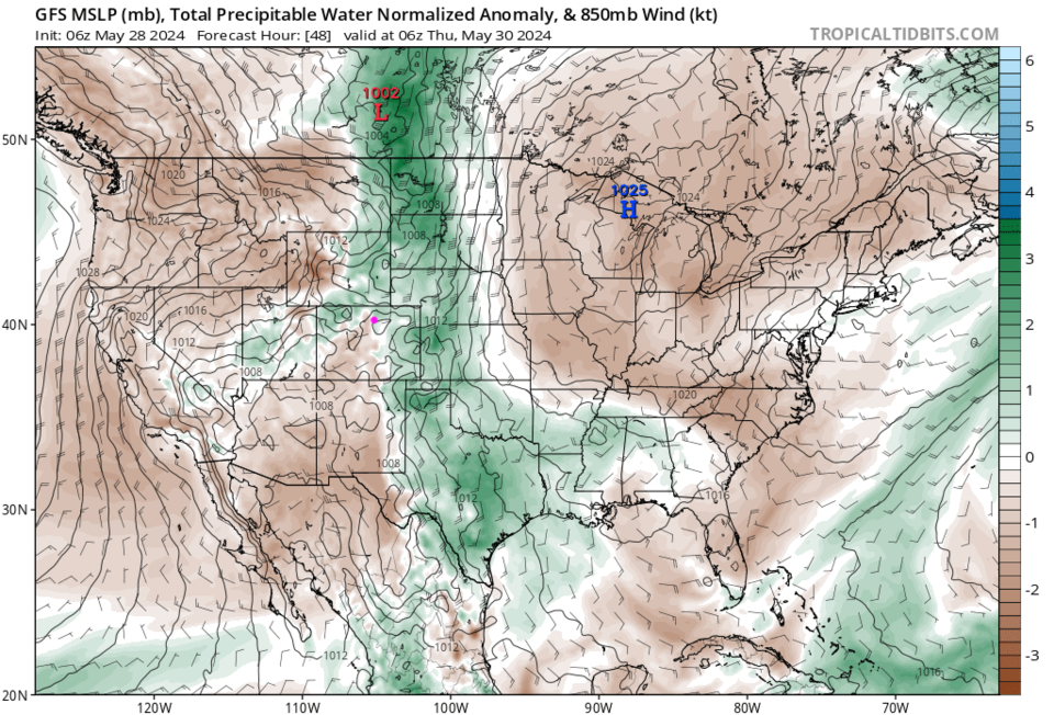
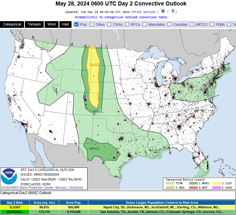
Moisture is returning (Figure 3) from the Gulf of Mexico and temperatures rise.  This means afternoon thunderstorms will become the norm again (Figure 1). An approaching trough (Figure 2) Wednesday will allow some of these storms to reach severe levels with damaging straight line winds and large hail being the primary threats (Figure 4).  Thursday will also see severe weather close or along I-25 again. Make sure your weather apps have notifications turned on!

figure1_05282024
Figure 1: the 10 day graphical forecast for Longmont from weatherunderground.com
figure2_05282024
Figure 2: The 500mb forecast upper air map for Thursday PM from the GFS and tropicaltidbits.com
figure3_05282024
Figure 3: The pricipitatable water forecast map for Wednesday AM from the GFS and tropicaltidbits.com
figure4_05282024
figure 4: the Day 2 severe weather forecast map from the NWS and the SPC for Wednesday.

The Longer Range Forecast:

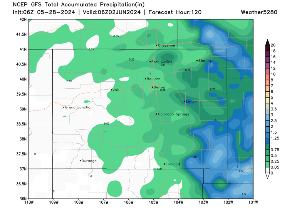
A strong ridge builds over the West by the end of the weekend taking us to summer-like temperatures (Figure 1).  Rainfall, over the next 5 days is spotty and largely confined to the eastern half of the state. 

figure5_05282024
Figure 5: the 5 day precipitation forecast from the GFS and weather5280.com


About the Author: John Ensworth

John Ensworth used to work from Longmont as the PI for the NASA through the IGES (The Institute for Global Environmental Strategies). He now teaches technology, algebra, astronomy, meteorology, film school, and Lego robotics to middle/high school.
Read more


Comments


Current Weather

Mostly cloudy

Mostly cloudy

60°F

UV Index
8 Very High
Pressure
30 Steady
Visibility
12 miles
Dewpoint
45 °F
Humidity
57%
Wind
ENE 3.2 mph
Gust
5.9 mph
Wind Chill
60 °F

Hourly Forecast

Today
12 PM
61°F
Intermittent clouds
Today
1 PM
63°F
Intermittent clouds
Today
2 PM
64°F
Mostly cloudy w/ t-storms
Today
3 PM
65°F
Intermittent clouds
Today
4 PM
63°F
Intermittent clouds
Today
5 PM
61°F
Intermittent clouds
Today
6 PM
59°F
Intermittent clouds
Today
7 PM
56°F
Intermittent clouds
Today
8 PM
53°F
Cloudy
Today
9 PM
51°F
Cloudy
Today
10 PM
49°F
Cloudy
Today
11 PM
48°F
Cloudy

7 Day Forecast

Partly sunny w/ t-storms

Thursday

65 °F

Intervals of clouds and sunshine with widely separated thunderstorms this afternoon


Thunderstorms

Thursday Night

44 °F

Overcast; a thundershower in spots this evening followed by a shower in spots late


Cloudy

Friday

51 °F

A shower in places in the morning; otherwise, a thick cloud cover and cooler


Mostly cloudy

Friday Night

45 °F

Low clouds breaking


Mostly cloudy w/ t-storms

Saturday

75 °F

Variable cloudiness with a thundershower; warmer


Clear

Saturday Night

43 °F

Clear


Partly sunny

Sunday

82 °F

Very warm with sunshine mixing with some clouds; elevated fire risk due to gusty winds and low humidity


Mostly clear

Sunday Night

46 °F

Mainly clear


Mostly cloudy

Monday

61 °F

Turning cloudy and cooler; a shower in spots in the afternoon


Intermittent clouds

Monday Night

39 °F

Clearing


Sunrise and Sunset

Sunrise
6:10 AM
Sunset
7:48 PM

Based on AccuWeather data