Skip to content
Join our Newsletter

The Front Range Forecast: Some rain or much rain everyday

In Brief:

Ample moisture and troughs/cut off lows to the west bring daily showers, numerous some days.

The Forecast Discussion:

The rain/showers/thunderstorms roll on. In just the last 48 hours, Longmont and Broomfield received about 1 to 1.5 inches of rain. Right now, no severe weather is expected, but the dotted green boxes (Figure 1) are days with afternoon thunderstorms and solid green boxes are periods of enhanced upflow that will keep showers going for much of the day(s).

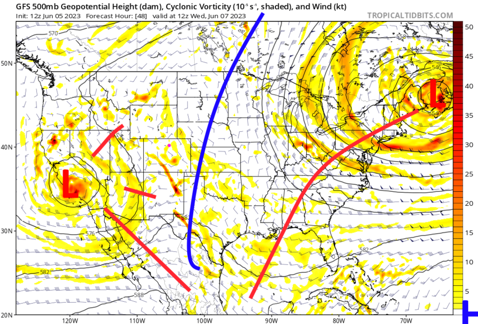
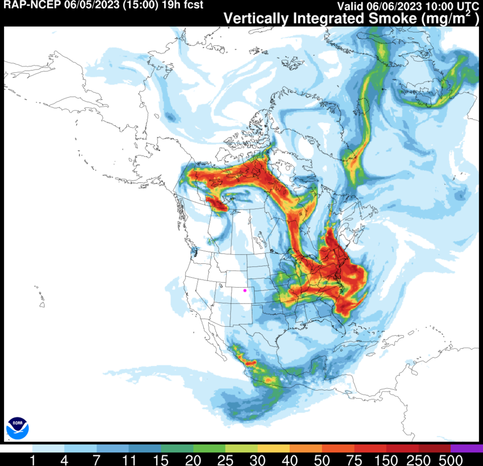
We still have a blocking high over the center of the nation and a low, that sometimes cuts off from the jet stream flow, to our west (Figure 2). This pattern is keeping Canada very hot and dry - the fires keep burning, but the smoke is headed out east (Figure 4).

Over the next 5 days, alone, The I -25 folks should see 0.25 to 0.5 inch more water and many inches will fall in the mountains. Wow, are things green out there.

figure1_06052023
Figure 1: the 10 day graphical forecast for Longmont from weatherunderground.com
figure2_06052023
Figure 2: the morning upper air forecast (500mb) from tropicaltidbits and the GFS.
figure3_06052023
Figure 3: the 5 day precipitation forecast from the GFS and weather5280.com
figure5_06052023
Figure 5: the Friday RAP model smoke forecast from NOAA.

The Longer Range Forecast:

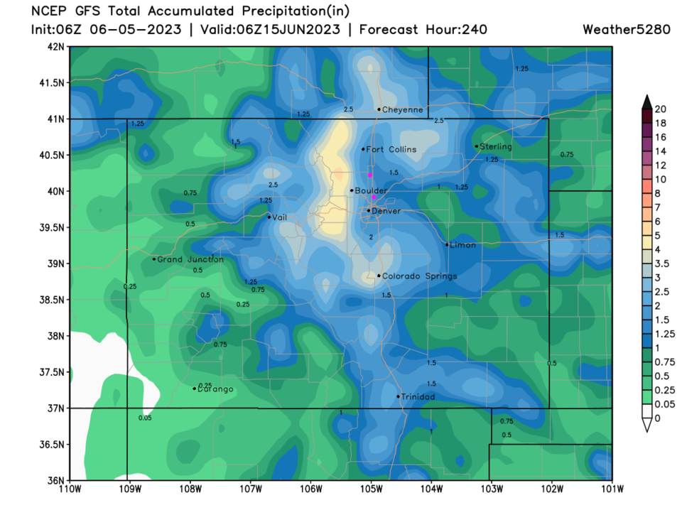
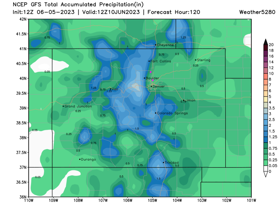
Over the next 10 days, the GFS is painting much of Colorado with 1-4 inches of total rainfall (Figure 5). Amazing.

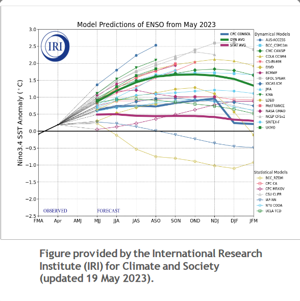
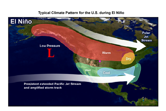
Looking even further out, there is, as covered as a possibility about 4 months ago here, a strong El Nino setting up (Figure 6). In this pattern, the west coast eastward will expect to receive normal to above normal precipitation (flooding will remain a concern from California through Arizona and eastward (Figure 7).  Colorado keeps normal precipitation going even if we may see somewhat warmer temperatures.

figure4_06052023
Figure 5: the 10 day precipitation forecast from the GFS and weather5280.com
figure6_06052023
Figure 6: the year to come El Nino forecast from NOAA.
figure7_06052023
Figure 7: the climatology of an El Nino map from NOAA.


About the Author: John Ensworth

John Ensworth used to work from Longmont as the PI for the NASA through the IGES (The Institute for Global Environmental Strategies). He now teaches technology, algebra, astronomy, meteorology, film school, and Lego robotics to middle/high school.
Read more


Comments


Current Weather

Drizzle

Drizzle

41°F

UV Index
0 Low
Pressure
30.16 Falling
Visibility
3 miles
Dewpoint
39 °F
Humidity
94%
Wind
N 2.1 mph
Gust
3.6 mph
Wind Chill
41 °F

Hourly Forecast

Tomorrow
12 AM
43°F
Rain
Tomorrow
1 AM
43°F
Rain
Tomorrow
2 AM
43°F
Intermittent clouds
Tomorrow
3 AM
43°F
Intermittent clouds
Tomorrow
4 AM
43°F
Intermittent clouds
Tomorrow
5 AM
43°F
Intermittent clouds
Tomorrow
6 AM
43°F
Intermittent clouds
Tomorrow
7 AM
45°F
Intermittent clouds
Tomorrow
8 AM
48°F
Fog
Tomorrow
9 AM
51°F
Fog
Tomorrow
10 AM
56°F
Fog
Tomorrow
11 AM
60°F
Fog

7 Day Forecast

Showers

Friday

46 °F

A thick cloud cover and chilly with a few showers


Mostly cloudy w/ showers

Friday Night

42 °F

Rain and drizzle this evening; otherwise, low clouds breaking


Mostly cloudy

Saturday

74 °F

Areas of fog in the morning; otherwise, warmer with variable cloudiness


Clear

Saturday Night

41 °F

Clear


Partly sunny

Sunday

80 °F

Very warm with sunshine mixing with some clouds; breezy in the afternoon; elevated fire risk due to gusty winds and low humidity


Partly cloudy

Sunday Night

46 °F

Partly cloudy


Mostly cloudy

Monday

64 °F

Turning cloudy, windy and cooler; a shower in spots in the afternoon


Mostly cloudy

Monday Night

39 °F

Cloudy in the evening, then partly cloudy late


Intermittent clouds

Tuesday

66 °F

Sun and clouds


Mostly clear

Tuesday Night

39 °F

Mainly clear


Sunrise and Sunset

Sunrise
6:08 AM
Sunset
7:49 PM

Based on AccuWeather data