Skip to content
Join our Newsletter

Thur Update: The Front Range Forecast: Snowfall Round-Up update

In Brief:

Still warm, some mountain snows, snow for everyone Friday.

Thursday update:

The forecasts quickly dropped all those high end snow totals mentioned below. This will be a chilly, windy storm with very little moisture.

Snowfall Round-Up for Longmont:

Weatherunderground: Tr-1"

Channel 7 news: 1.8"

Channel 9 news: 1.5"

NWS: <1"

Weather 5280.com  T-1"

The GFS 0-0.5 inch.

The NAM 1.5-2.5 inches.

My forecast: 0-1 inch.

It's just not a big storm this time!


End Thursday update.

Tuesday update:

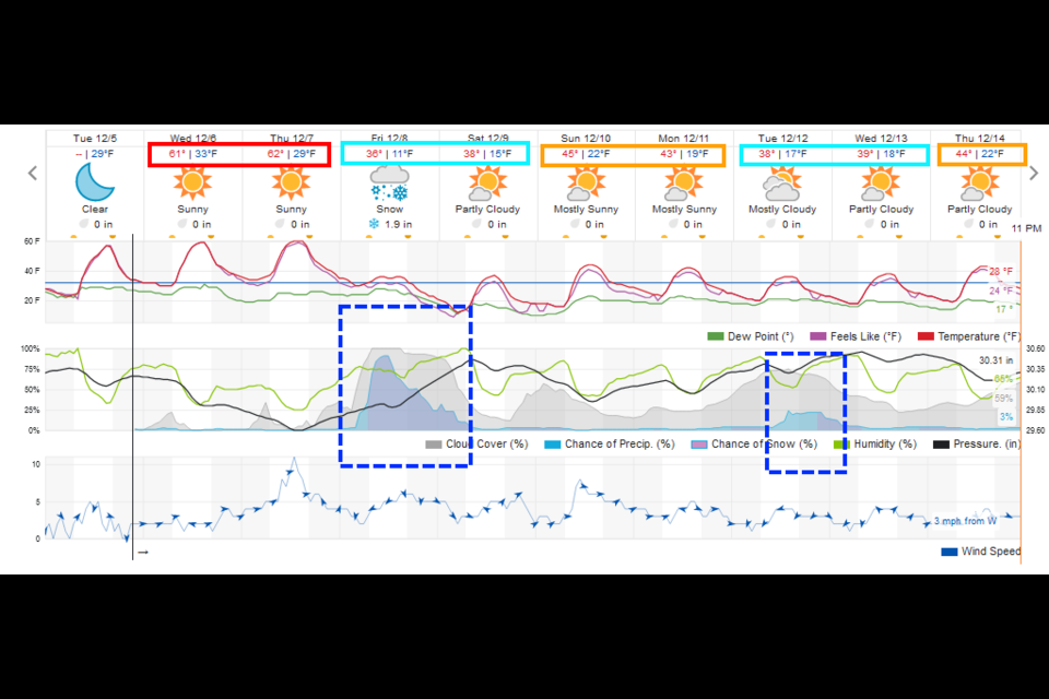
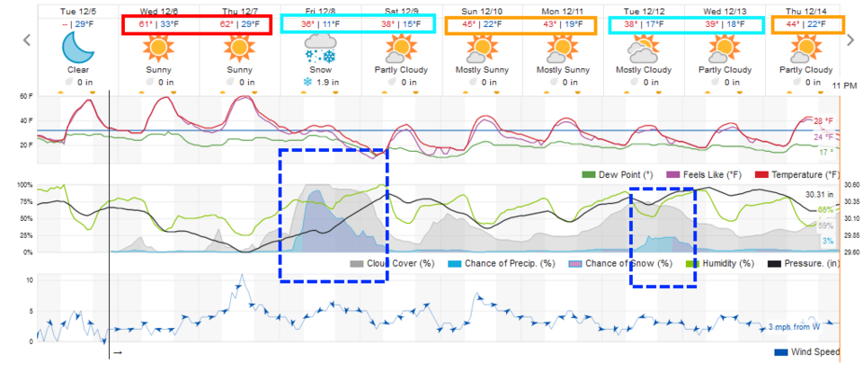
We continue with temperatures about 20F above normal until a cold front arrives overnight Thursday/Friday (Figure 1 update) . Pretty good snow chances in the low lands of I-25. Most models giving 1-3 inches of snow. Some (less used by me) models are jumping on 6 or 8 inch totals along I-25. I have low confidence of this but the snowfall round up will come out in a couple of days.

More details as the models (hopefully) come into agreement with each other!

figure1u_12052023
Figure 1 update: the 10 day graphical forecast for Longmont from weatherunderground.com

End Tuesday update.

Forecast Discussion:

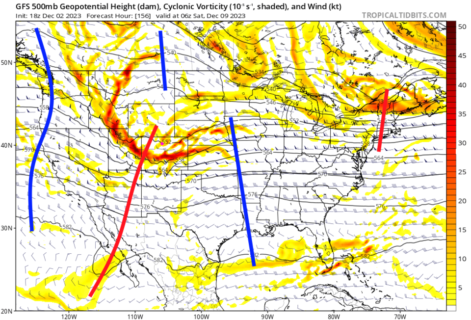
Upslope flow is giving the western slopes and higher mountains much needed snow.  All we get is a view of clouds doubling the height of the Rockies, wind, and cool temperatures (Figure 1). A ridge returns to the West and we warm up to 20-25F above normal much of the week.

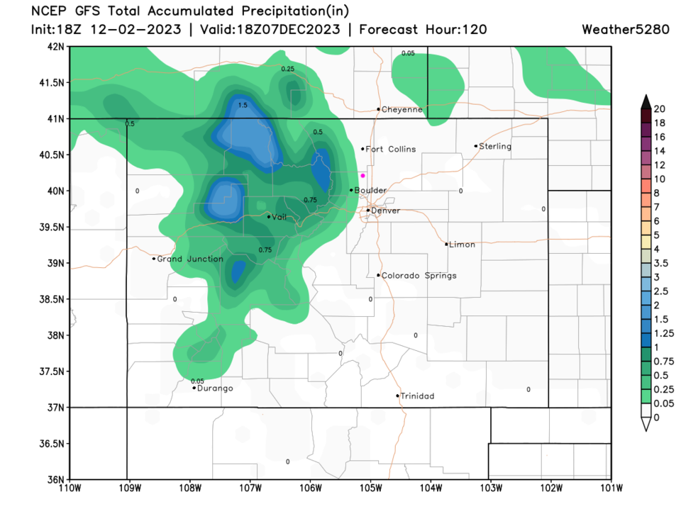
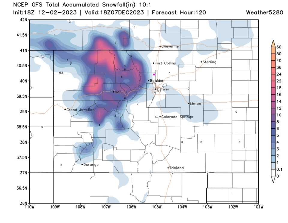
Over the next 5 days, the precipitation (moisture - Figure 3) and snow (Figure 4) falls mainly in the mountains.


figure1_12022023
Figure 1: the 10 day graphical forecast for Longmont from weatherunderground.com

The Long Range Forecast:

A new trough approaches Friday night/Saturday morning (Figure 2). We have a 'chance' of some snow from that system (Figure 1).

figure2_12022023
Figure 2: the forecast 500mb upper air map for next Saturday am from the GFS and tropicaltidbits.com
figure3_12022023
Figure 3: the 5 day precipitation forecast from the GFS and weather5280.com
figure4_12022023
Figure 4: the 5 day snowfall (10:1 ratio) forecast from the GFS and weather5280.com


About the Author: John Ensworth

John Ensworth used to work from Longmont as the PI for the NASA through the IGES (The Institute for Global Environmental Strategies). He now teaches technology, algebra, astronomy, meteorology, film school, and Lego robotics to middle/high school.
Read more


Comments


Current Weather

Partly cloudy

Partly cloudy

69°F

UV Index
0 Low
Pressure
30.14 Steady
Visibility
12 miles
Dewpoint
60 °F
Humidity
73%
Wind
NW 3.2 mph
Gust
4.3 mph
Wind Chill
69 °F

Hourly Forecast

Tomorrow
12 AM
67°F
Mostly cloudy w/ showers
Tomorrow
1 AM
65°F
Partly cloudy
Tomorrow
2 AM
64°F
Mostly clear
Tomorrow
3 AM
62°F
Clear
Tomorrow
4 AM
61°F
Clear
Tomorrow
5 AM
60°F
Clear
Tomorrow
6 AM
58°F
Sunny
Tomorrow
7 AM
62°F
Sunny
Tomorrow
8 AM
68°F
Mostly sunny
Tomorrow
9 AM
74°F
Mostly sunny
Tomorrow
10 AM
80°F
Mostly sunny
Tomorrow
11 AM
84°F
Mostly sunny

7 Day Forecast

Intermittent clouds

Saturday

82 °F

Clouds giving way to sun; high levels of ozone will lead to poor air quality


Mostly clear

Saturday Night

58 °F

A shower in spots late this evening; otherwise, clear to partly cloudy


Partly sunny w/ showers

Sunday

94 °F

Partly sunny with a passing shower in the afternoon


Partly cloudy

Sunday Night

61 °F

Partly cloudy


Mostly cloudy w/ t-storms

Monday

94 °F

Some sun, then increasing clouds with a thundershower in spots in the afternoon


Mostly clear

Monday Night

60 °F

Clear to partly cloudy


Intermittent clouds

Tuesday

92 °F

Sun through high clouds


Partly cloudy

Tuesday Night

60 °F

Partly cloudy


Intermittent clouds

Wednesday

81 °F

Not as warm with times of clouds and sun; a thunderstorm in spots in the afternoon


Intermittent clouds

Wednesday Night

58 °F

An evening thunderstorm; otherwise, partly cloudy


Sunrise and Sunset

Sunrise
5:41 AM
Sunset
8:30 PM

Based on AccuWeather data