This content was originally published by the Longmont Observer and is licensed under a Creative Commons license.
By John Ensworth
Discussion:
We have westerly and northwesterly flow aloft and drying occurring across Colorado. Even with less moisture, the mountains can still get daily storms, but values of precipitatable water were around 1.00” are expected to drop to 0.50” to 0.75”. We’ll see more drying and warming (to the low 90’s again) as the weekend approaches. (Note, the cloud forecast for Wyoming and Nebraska for the eclipse is in a special section below.)
Figure 1 shows the drying air (darker grey) over Colorado and the monsoon moisture remaining confined (outlined in green) to the distant south of the state.
Figure 1: Water Vapor satellite image from Thursday night. Very dry air is shown as red and orange, very moist air is in brighter grey, white and pink.

Figure 2 shows the upper air pattern with the big ridge off to the west and the (in red) trough that kicked off the from the Dakotas down through Nebraska, Kansas, Oklahoma, and Texas Thursday evening. The flow, though, is from the west and northwest due to that western ridge. Not a very wet pattern.
Figure 2: The 500mb analysis from Thursday evening.

In a look at the longer range:
Westerly flow continues, so moisture will be limited, but a trough replaces our ridge out west by Sunday morning – Figure 3– and some southwest moisture will begin to approach. We are close enough to see what the GFS thinks about rainfall along the eclipse path in the longer range. Figure 4 shows (my ‘roughly’ hand drawn) eclipse path in purple and not much actual rain from central Wyoming to western Nebraska. Keep fingers crossed!
Figure 3: The GFS forecasted 500mb map for Sunday morning. Troughs are marked in red, ridges marked in blue, moisture flow in green.

Figure 4: The GFS forecasted surface precipitation map for Monday morning. The purple line is a rough depiction of the eclipse path.

_________________________________________________________________
Eclipse forecast special:
We continue to build a trend chart here for a sampling of eclipse viewing locations. Each forecast will be for the expected % cloud cover (0% is clear, 100% is overcast) at 12pm Mountain Time for Teton Village, WY, Casper, WY, Glendo, WY, Lusk, WY, Alliance, NE, and Longmont, CO (Longmont is included for reference… it will NOT be in the totality path).
I’ll add each day’s model forecast for that time from Sunday night to Sunday night. The important thing to watch is the trend. Does your city look clearer as the week goes on, or more cloudy, or pretty constant? My expectation is that you will not be able to move far from where you are Monday morning due to traffic. You’ll need to pick your destination a day out and plan for that.
Thursday commentary: Cloud forecasts, even 4 days out, are not expected to be good. For those in western Wyoming and around Longmont, the model has gotten a good deal cloudier (it might be monsoon moisture for both). Central and eastern Wyoming and western Nebraska have improved over the last few days model runs.
| Percent Cloud Cover Forecasted for | Sun 8/13 | Mon 8/14 | Tue 8/15 | Wed 8/16 | Thur 8/17 | Fri 8/18 | Sat 8/19 | Sun 8/20 |
| Teton Village | 26% | 30% | 12% | 41% | 54% |
| Casper | 9% | 27% | 38% | 43% | 15% |
| Glendo | 13% | 31% | 33% | 38% | 24% |
| Lusk | 9% | 26% | 22% | 23% | 14% |
| Alliance | 7% | 36% | 39% | 37% | 23% |
| Longmont | 23% | 45% | 22% | 34% | 54% |
A Map Version of Cloud Forecasts
These maps were created by www.weather5280.com (you should visit them for weather discussion as well!). These maps are a cloud forecast map (future satellite image, sort-of) with percent cloud cover plotted and the eclipse path added for reference by those talented forecasters and programmers. All of these are for the same time and date – noon on Monday, Mountain Time, near totality of the eclipse. As with the table above, keep an eye on the trends and patterns. If they change a lot day to day, confidence is low that the models are getting it right. If they are consistent, then you can place some confidence in this forecast. This is a different model than the one creating the percentage table above, so if these numbers match those, you can be even happier that you know what Monday will be like. Never allow yourself to be completely confident that this is what Monday will yield.
Thursday commentary: the model is creating, now, less overall cloudiness around the nearby path of totality. This is a good trend in this model.
Forecast created Sunday 8/13

Forecast created Monday 8/14

Forecast created Tuesday 8/15

Forecast created Wednesday 8/16

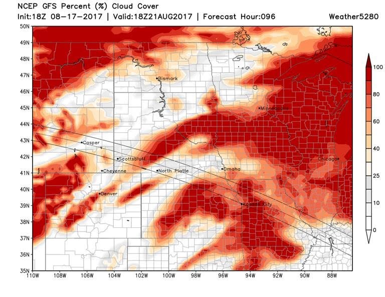
Forecast created Thursday 8/17

*** This feature will run as close to daily as possible in this location on the Longmont Observer. ***
This article will provide a brief discussion concerning the ‘why’ behind the weather with a focus on severe weather, unusual weather, and snow (especially trying to predict snow depth and its human impact in Longmont).
Bio:
John Ensworth works from Longmont as the Principle Investigator for the NASA Science Mission Directorate Earth and space science education product review through the IGES (The Institute for Global Environmental Strategies – www.strategies.org) . He is in his 14th year running this review. He is an astronomer (from the 2nd grade onward) and became a meteorologist (in the 5th grade) when a thunderstorm in Arizona rained on his telescope when the weather service had only forecasted a 10% chance of rain. He has college degrees in physics and astronomy and climatology and a graduate degree in meteorology and earth science. He lectures at the Little Thompson Observatory in Berthoud, the Estes Park Memorial Observatory in Estes Park, and for a number of online universities. He built and runs a backyard observatory near Pace and 17th in northeast Longmont where he has lived for 8 years with his wife, daughter, son, and two cats. Invitations to open house nights at this observatory, LTO, and EPMO will be posted with future discussions when they are scheduled.
Forecasting severe weather and snow amounts via text lead to this column. He began texting friends about the weather right after the September 2013 flood. The readers of this column will, hopefully, keep him honest in what he ‘thought’ he had forecasted for ‘the most recent’ storm.


