This content was originally published by the Longmont Observer and is licensed under a Creative Commons license.
By John Ensworth
Discussion:
The severe weather risk retreated further east yesterday and not much happened in Longmont except lots of cooling cloudiness and outflow wind associated with the moisture axis and weak mountain thunderstorms following the ridge as it passed. Figure 1 is our water vapor satellite image showing the ‘fountain’ of tropical air with green arrows now headed into Kansas, Oklahoma and Nebraska. Now hurricane Harvey is headed for landfall in Texas. There are situations where tropical moisture like this can make it to Colorado, but as we’ll see shortly, that is unlikely. Figure 2 shows the low level moisture headed up to but mainly remaining south of Colorado by tonight. Figure 3 shows the ridge past us but a broad region of slow flow across the southern half of the nation. The rapidly moving ridges and troughs are remaining active across the northern tier of states. An overall ridge (the southern half) this wide (wider than the U.S.) might begin to retrograde (move westward) through the weekend. As Joe Bastardi of Weather Bell says – the weather pattern that is good for a hurricane is a ‘ridge over troubled waters.’
Figure 1: The Thursday PM water vapor satellite image view (dry=red/orange, very wet = purple/white, greys are medium moist).

Figure 2: The NCEP surface analysis and precipitation chances forecast for Friday night.

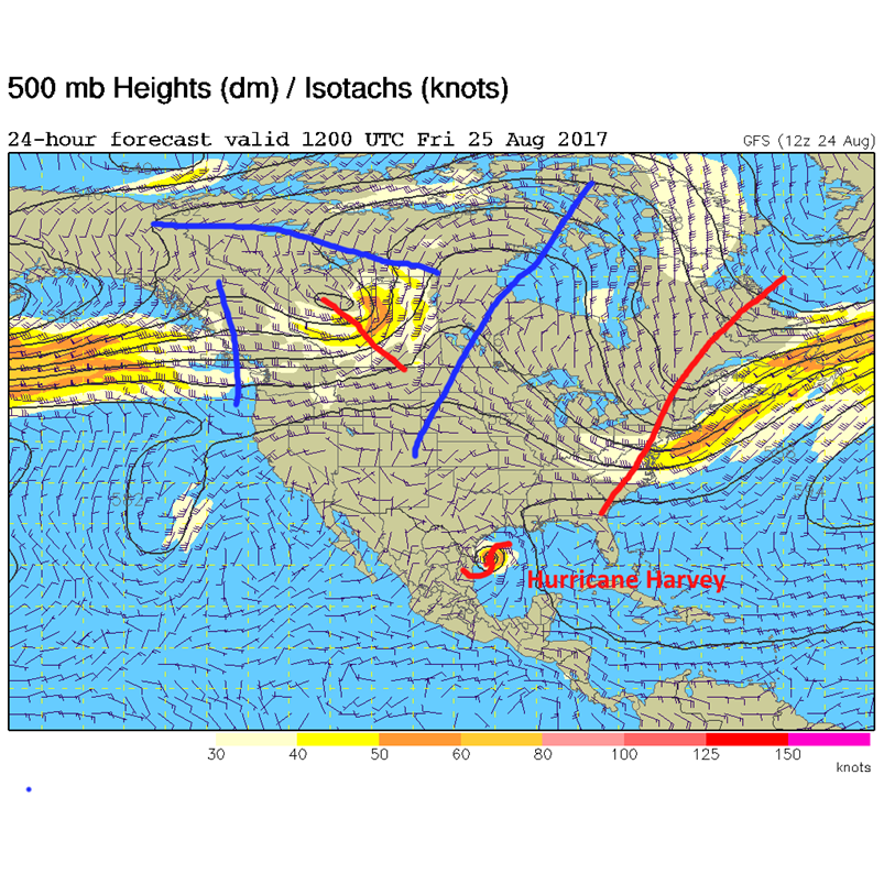
Figure 3: The Friday AM 500mb map from the GFS. The broad ridge axis is the long blue line, the shorter wave trough and ridge patterns are sliding across the U.S. Canada border.

In a look at the longer range:
Things dry out and stay seasonal in temperature as the ridge builds to our west and somewhat over us through the weekend. By Monday, the ridge (unless it moves to the west) circulation pattern will be such that any moisture, from stalled out Harvey remains, would have a LONG trip to make (Figure 4). That isn’t very likely, but we’ll watch for a westward drift.
Figure 4: The GFS forecasted upper air analysis showing a long path for Harvey moisture to make – if it ever does by Monday.
*** This feature will run as close to daily as possible in this location on the Longmont Observer. ***
This article will provide a brief discussion concerning the ‘why’ behind the weather with a focus on severe weather, unusual weather, and snow (especially trying to predict snow depth and its human impact in Longmont).
Bio:
John Ensworth works from Longmont as the Principle Investigator for the NASA Science Mission Directorate Earth and space science education product review through the IGES (The Institute for Global Environmental Strategies – www.strategies.org) . He is in his 14thyear running this review. He is an astronomer (from the 2nd grade onward) and became a meteorologist (in the 5th grade) when a thunderstorm in Arizona rained on his telescope when the weather service had only forecasted a 10% chance of rain. He has college degrees in physics and astronomy and climatology and a graduate degree in meteorology and earth science. He lectures at the Little Thompson Observatory in Berthoud, the Estes Park Memorial Observatory in Estes Park, and for a number of online universities. He built and runs a backyard observatory near Pace and 17th in northeast Longmont where he has lived for 8 years with his wife, daughter, son, and two cats. Invitations to open house nights at this observatory, LTO, and EPMO will be posted with future discussions when they are scheduled.
Forecasting severe weather and snow amounts via text lead to this column. He began texting friends about the weather right after the September 2013 flood. The readers of this column will, hopefully, keep him honest in what he ‘thought’ he had forecasted for ‘the most recent’ storm.


