This content was originally published by the Longmont Observer and is licensed under a Creative Commons license.
Issued: Tuesday July 11, 2017
By John Ensworth
This feature will run as close to daily as possible in this location on the Longmont Observer.
This article will provide a brief discussion concerning the ‘why’ behind the weather with a focus on severe weather, unusual weather, and snow (especially trying to predict snow depth and its human impact in Longmont).
Discussion:
Our headline ridge is now centered over Kansas. On Wednesday it will be quite flat, but the center will be roughly around Illinois. Then the ridge begins to build/bulge northward on Thursday over the Utah/Colorado border. On Friday it will be centered on top of us again. But this jaunt to the east will let moisture come into the state from the topics. Hurray! Arizona, Utah, and Western Colorado get the best chances of rain/thunderstorms, but, like we saw Monday, foothill thunderstorm formations will move out east and provide shade and cooler air even if Longmont itself doesn’t get rain sometimes. By the weekend, the ridge is back and big over Utah. Will we have a backdoor cold front brush us early next week? We’ll see… Meanwhile, our best chance of rain will be Wednesday and Thursday afternoons as the ridge resides out east for a couple of days and the monsoon briefly sputters to life.
The record high for Monday was 98F set in 2016, but the above mentioned foothills formations formed and spread east, cooling Longmont down and cutting the high to only 94F. That is pretty toasty but we didn’t break the record. (DIA hit 96F, two degrees shy of their record as well.)
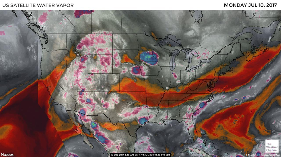
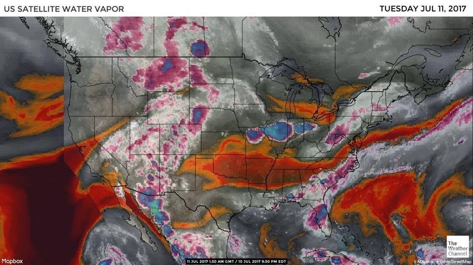
Today is day 2 of our moisture-flow-watch associated with this first gasp of the summer monsoon. In the images below (taken Sunday night and Monday night locally) we see the water vapor image from the Weather Channel’s Website. As described yesterday, the satellite is looking at frequencies of light emitted by the Earth that are absorbed by moisture in the atmosphere. The deep red and orange colors are places where the atmospheric moisture content is very low from the surface up to the top of the troposphere. The grey areas have some moisture. The white and pink regions have a high moisture content.
You can see that the feed of moisture across the southern US on into Texas, New Mexico, and up into western Colorado is a bit wetter than yesterday. There is another feed of moisture from Mexico and the Gulf of Mexico that goes up into Arizona, Utah and on to Canada which also looks very healthy. The colors over Colorado show that a moderate amount of atmospheric moisture now covers all of our state. The tongue of very dry air that was in SE Colorado has pushed further southeast into New Mexico and the panhandles of Oklahoma and Texas. See ya later dry air!
An interesting note, you can see Tropical Storm Eugene just off the bottom edge toward the left corner of the image in the eastern Pacific. And you can see that its moisture is not really connected into the river of air headed into the US.
In a look at the longer range: we know that the ridge will expand back to the west next weekend, but with moisture in place, the mountains will continue to receive more afternoon thunderstorm activity than we have yet seen this summer. We don’t return to the mid 90’s again until Sunday as the air dries out and the ridge strengthens again.
Bio:
John Ensworth works from Longmont as the Principle Investigator for the NASA Science Mission Directorate Earth and space science education product review. He is in his 14th year running this review. He is an astronomer (from the 2nd grade onward) and became a meteorologist (in the 5th grade) when a thunderstorm in Arizona rained on his telescope when the weather service had only forecasted a 10% chance of rain. He has college degrees in physics and astronomy and climatology and a graduate degree in meteorology and earth science. He lectures at the Little Thompson Observatory in Berthoud, the Estes Park Memorial Observatory in Estes Park, and for a number of online universities. He built and runs a backyard observatory near Pace and 17th in northeast Longmont where he has lived for 8 years with his wife, daughter, son, and two cats. Invitations to open house nights at this observatory, LTO, and EPMO will be posted with future discussions when they are scheduled.
Forecasting severe weather and snow amounts via text lead to this column. He began texting friends about the weather right after the September 2013 flood. The readers of this column will, hopefully, keep him honest in what he ‘thought’ he had forecasted for ‘the most recent’ storm.


