This content was originally published by the Longmont Observer and is licensed under a Creative Commons license.
By John Ensworth
Discussion:
Our wandering summer ridge is now living large out west of us giving us a northerly fetch of atmospheric flow. There is dry air coming down (Figure 1) and has lowered precipitatable water amounts to 0.70” from values around twice that just in the last week. That is a bit lower than normal seasonally, so we didn’t see anything but a few tiny cells pop off along the Front Range that died pretty quickly. The flash flood watches and thunderstorms are all down in Arizona and New Mexico (what a year for Arizona and rain!!).
Figure 1: 500mb map showing the big ridge out over Nevada and Utah and the northerly dry air coming down (and keeping us relatively cool – compared to what it could be).
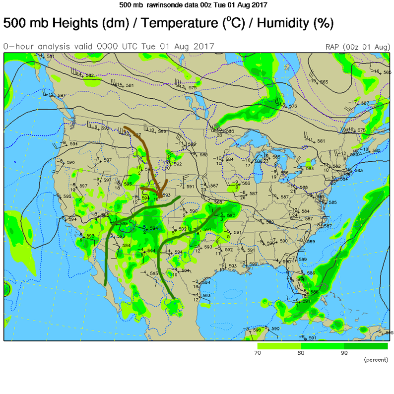
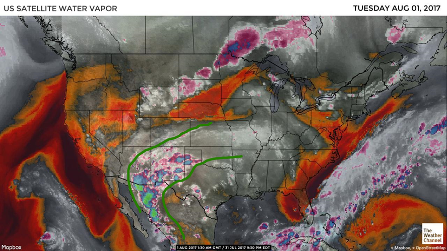
Figure 2 shows our water vapor satellite with the deeper moisture outlined in green. We have enough moisture in place for some clouds now and then up in the mountains west of Longmont and along I-25.
Figure 2: Water vapor satellite image (dry air = reds and oranges, moist air = dark-light grey, very moist air= white to purple or blue).
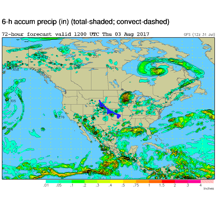
In a look at the longer range: The low level moisture isn’t far away this week, but the ridge will amplify west of us and eventually head off the coast. Figure 3 shows a tightening of the gradient (how close the black lines are) over the upper Midwestern U.S. which occurs with a cold front that pushes down. Highs on Thursday may only hit the upper 60’s or lower 70’s in Longmont. Positively chilly! Figure 4 shows the 6 hour accumulation of rainfall on Thursday as that cold front plows in. Hurray! The ridge stays west (and a trough digs through the ridge ) on into the weekend keeping temperatures in the 80’s and sometimes upper 70’s through the weekend. Rain chances stay pretty good each day as well (things may get a bit drier Friday to Saturday, then moisten up again after that).
Figure 3 The GFS 500mb map showing the approaching jet stream/tightening of the lines/gradient to our north east and the cold front that will change the weather on Thursday 8/3. Thursday morning’s map.
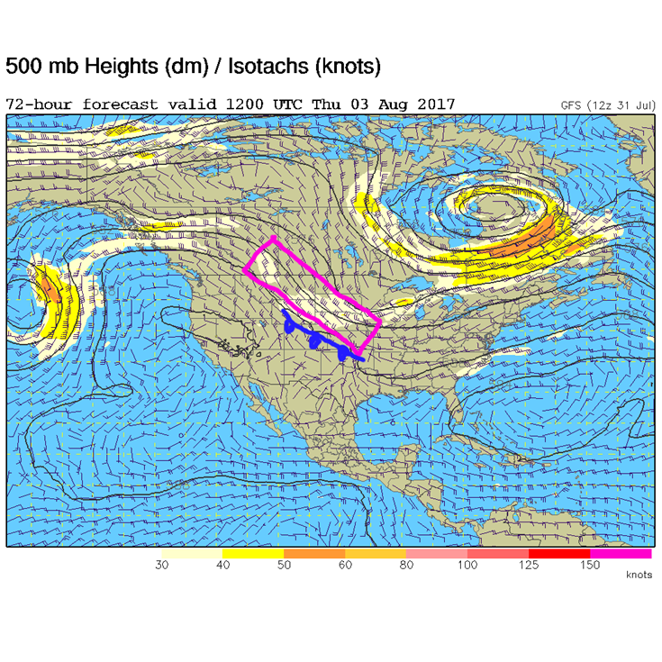
Figure 4: The GFS 6 hour accumulation rainfall forecast for Thursday 8/3.
*** This feature will run as close to daily as possible in this location on the Longmont Observer. ***
This article will provide a brief discussion concerning the ‘why’ behind the weather with a focus on severe weather, unusual weather, and snow (especially trying to predict snow depth and its human impact in Longmont).
Bio:
John Ensworth works from Longmont as the Principle Investigator for the NASA Science Mission Directorate Earth and space science education product review through the IGES (The Institute for Global Environmental Strategies – www.strategies.org) . He is in his 14thyear running this review. He is an astronomer (from the 2nd grade onward) and became a meteorologist (in the 5th grade) when a thunderstorm in Arizona rained on his telescope when the weather service had only forecasted a 10% chance of rain. He has college degrees in physics and astronomy and climatology and a graduate degree in meteorology and earth science. He lectures at the Little Thompson Observatory in Berthoud, the Estes Park Memorial Observatory in Estes Park, and for a number of online universities. He built and runs a backyard observatory near Pace and 17th in northeast Longmont where he has lived for 8 years with his wife, daughter, son, and two cats. Invitations to open house nights at this observatory, LTO, and EPMO will be posted with future discussions when they are scheduled.
Forecasting severe weather and snow amounts via text lead to this column. He began texting friends about the weather right after the September 2013 flood. The readers of this column will, hopefully, keep him honest in what he ‘thought’ he had forecasted for ‘the most recent’ storm.


