This content was originally published by the Longmont Observer and is licensed under a Creative Commons license.
By John Ensworth
Discussion:
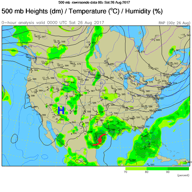
Aaaand… the pattern stalls. This might end up being tragic for the Texas Gulf Coast. Just a little moisture remains in place for afternoon foothills thunderstorms that may drift over Longmont for a brief while each afternoon this weekend and beyond. Figure 1 shows the surface High pressure over southern CO and the category 4 hurricane hitting Texas. This is how the weather will look for days to come. Figure 2 shows the forecasted central position of Hurricane Harvey (and it’s remains). They stay nearly stationary. This is bad news for the coast of Texas. Figure 3, with a green outline, shows the limit of the deep tropical moisture currently. We are drying out in Colorado. Figure 4 shows the High in the Southwestern states and the tropical system on the coast of Texas. We’ll see that this doesn’t change much even into the middle of next week!!!
Figure 1: The surface map with radar background Friday PM/Saturday AM.

Figure 2: The Weatherunderground 5 day forecast for Hurricane Harvey.

Figure 3: The Friday PM water vapor satellite image view (dry=red/orange, very wet = purple/white, greys are medium moist)..

Figure 4: The 500 mb map for Friday PM showing a high over Arizona and the big tropical system on the Texas Coast.

In a look at the longer range:
Things dry out and stay seasonal in temperature as the ridge builds to our west and somewhat over us through the weekend. What is really interesting is how little the pattern changes for days and days to come. Figure 5 is for Sunday night. Figure 6 is Monday night. Figure 7 is Tuesday night. Figure 8 is Wednesday night. Other than hurricane Harvey dying, very little changes. Warm and mostly dry conditions exist for the Front Range and Longmont.
Figure 5: The GFS forecasted upper air analysis for Sunday PM.

Figure 6: The GFS forecasted upper air analysis for Monday PM.

Figure 7: The GFS forecasted upper air analysis for Tuesday PM.

Figure 8: The GFS forecasted upper air analysis for Wednesday PM.

*** This feature will run as close to daily as possible in this location on the Longmont Observer. ***
This article will provide a brief discussion concerning the ‘why’ behind the weather with a focus on severe weather, unusual weather, and snow (especially trying to predict snow depth and its human impact in Longmont).
Bio:
John Ensworth works from Longmont as the Principle Investigator for the NASA Science Mission Directorate Earth and space science education product review through the IGES (The Institute for Global Environmental Strategies – www.strategies.org) . He is in his 14th year running this review. He is an astronomer (from the 2nd grade onward) and became a meteorologist (in the 5th grade) when a thunderstorm in Arizona rained on his telescope when the weather service had only forecasted a 10% chance of rain. He has college degrees in physics and astronomy and climatology and a graduate degree in meteorology and earth science. He lectures at the Little Thompson Observatory in Berthoud, the Estes Park Memorial Observatory in Estes Park, and for a number of online universities. He built and runs a backyard observatory near Pace and 17th in northeast Longmont where he has lived for 8 years with his wife, daughter, son, and two cats. Invitations to open house nights at this observatory, LTO, and EPMO will be posted with future discussions when they are scheduled.
Forecasting severe weather and snow amounts via text lead to this column. He began texting friends about the weather right after the September 2013 flood. The readers of this column will, hopefully, keep him honest in what he ‘thought’ he had forecasted for ‘the most recent’ storm.


