This content was originally published by the Longmont Observer and is licensed under a Creative Commons license.
For this fourth part of our eclipse coverage, I’ll give you some tips on how to forecast for yourself if your chosen location will have clear skies on the morning of August the 21st. It would be terrible to get the safe viewing aids, pack your car with food, water, and toilet paper, leave early enough to get ahead of the L.A. style traffic, only to drive to a spot under a layer of clouds from horizon to horizon.
The good thing about this eclipse is that it is happening fairly close to noon. That puts the sun up almost as high as at can be at this time of year (in Casper, WY for example, it will be 43 degrees up when the first nip appears in the side of the sun, and 59 degrees up at the end (overhead is 90 degrees, the horizon is 0 degrees altitude). Even if there are some clouds – especially the puffy cumulus kind – you are more likely to get breaks in the clouds near overhead than you are looking at an eclipse low to the horizon.
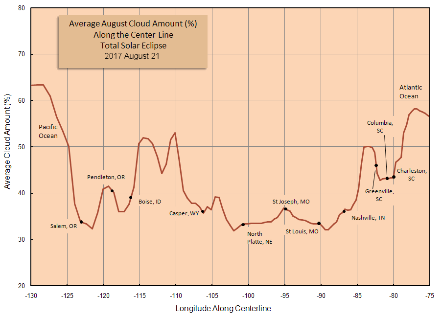
The other thing that is going for us is that, at least in eastern Wyoming and Nebraska. some of the best skies at that time of the morning at that time of year are normal. Figure 1 shows this cloud climatology across the nation. Figure 2 shows a cross section from west to east along the path. Wyoming into Nebraska look great! Sadly, where there are the most people, on both coasts, there are also often more clouds. Yikes.
Figure 1: Cloud cover by area.
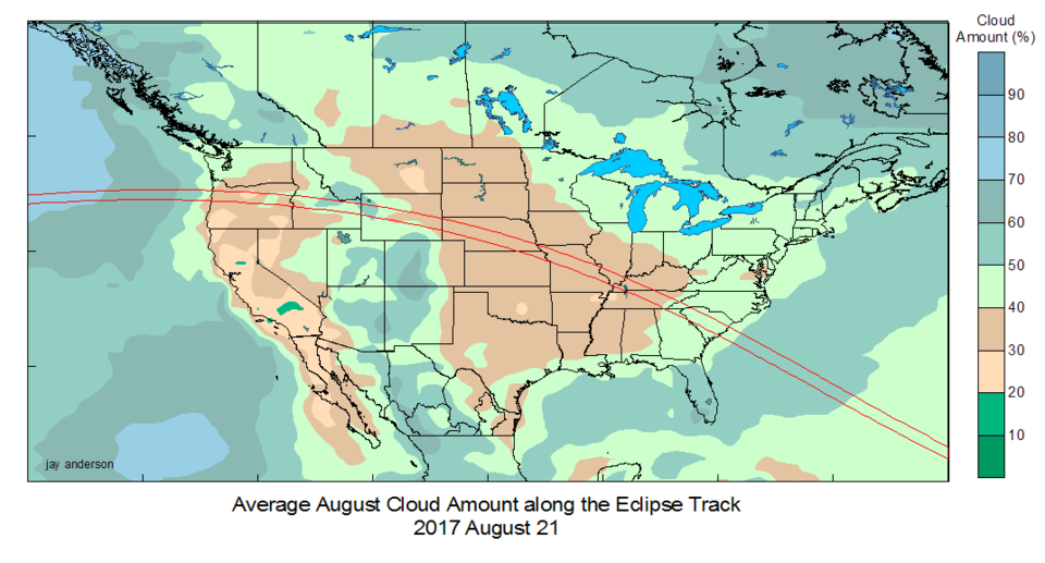
Figure 2: Cloud percent cross section down the path of totality.
But every day its own day. We don’t care about averages as much as we want to know what to expect on THE day for the spot we are headed to. There are a number of numerical models available that attempt to predict clouds. I’ll give you a sampling of these for you to use.
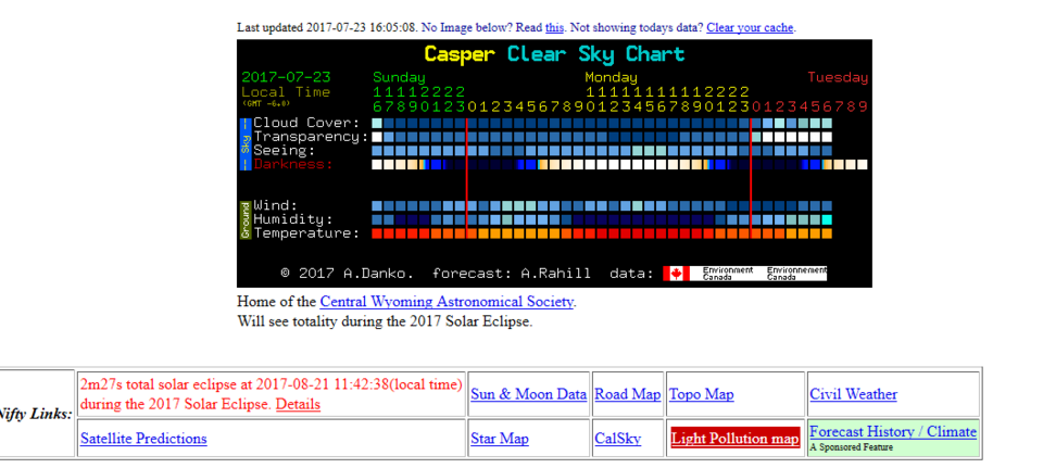
The first is for astronomers year-round. It is called Clear Sky Chart: http://cleardarksky.com/csk/ On this site you can put in the GPS coordinates of your chosen location, or name of the nearest town, and it will generate a gird for the next, approximately, 48 hours that shows Cloud Cover on the top line. Transparency (hazy conditions) is drawn on the second line. How much stars twinkle (Seeing) is on the third line. You will be most concerned with actual Cloud Cover. White is bad/cloudy, dark blue is good/clear. You can see much of the totality effects even with some haze (just not TOO much). Poor seeing (white) could make more pronounced shadow bands (we’ll cover what those are in a figure part).
Here is an example of what this chart looks like for Casper, Wyoming today.
Figure 3: Clear Sky Chart for Casper Wyoming captured Sunday 7/23 at 5pm MT.
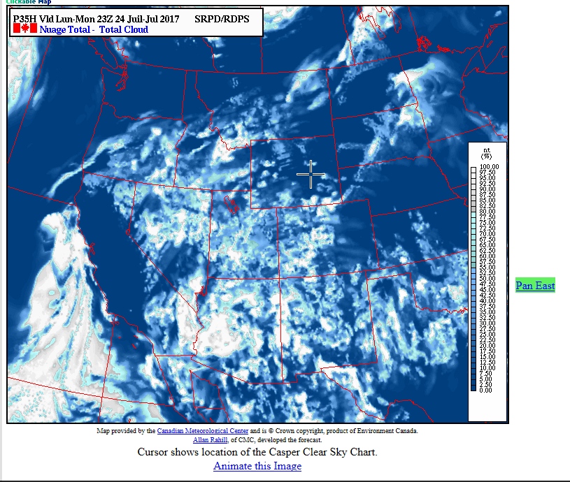
What is also great about this site is that there is a box next to Nifty Links below each chart that has a lot of great data, including a box specifically for this eclipse. That page has a bunch of detailed climatological information for your site. Please explore it long before setting on where you want to go. Something else incredible about this chart is what happens when you click ON one of the boxes. It takes you to a future satellite image. This can really help you pick between a couple of sites a day before you head out. I’ll click on the Cloud Cover box for 17:00 (5pm) on Monday in the example chart above.
Figure 4: Future satellite image for 5pm Monday on the chart above. There is a ‘plus’ sign marking your chosen site.
Another site that is similar to this (but not as full featured) uses a different model. It is nice for a second opinion. It is out of China and is called 7Timerhttp://7timer.org/wchart.php?lang=en . Right now, the cloud cover circles row is broken (it has been for more than a week). Hopefully this site comes back up before the eclipse.
Another site that generates future satellite images is located at NCAR http://weather.rap.ucar.edu/model/ . It is the Real-Time Weather Data. Under the Forecast tab, you will see an entry for Clouds: all levels. Over on the left, you can pick loop all times, or check just the time (up to 18 hours before the eclipse) of the eclipse and see what the clouds are doing over the U.S. None of these tools go too far into the future since it is so hard to model just clouds.
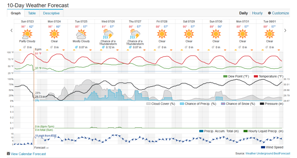
Finally, the great site Wundergound (or weatherunderground.com) https://www.wunderground.com/ will give you a graphical cross section over time of cloud cover for anywhere in the world for a number of days out. The trick is you need to subscribe to their ad-free value-added level of service…but it is only $10 a year. Here is what the cloud cover (in grey, behind the solid black line for atmospheric pressure) looks like, along with chances of rain, temperature, dew point information in Figure 5. Note, it does go out 10 days… don’t believe it much beyond about 48 hours; the computer models often make up things beyond that.
Figure 5: Paid wunerground forecast for Casper Wyoming.
here are more resources I’ve included in the link below. Be familiar with the tools now before that weekend arrives. Happy hunting!
Our fourth batch of useful Eclipse Information links (related to the text above):
Cloud cover climatology from eclipse2017.org http://www.eclipse2017.org/2017/weather/2017_clouds.htm
Clear Sky Chart: http://cleardarksky.com/csk/ (There are smart phone/pad apps for this site as well.)
UCAR Real-Time Weather Data http://weather.rap.ucar.edu/model/
Weather Underground/Wunderground: https://www.wunderground.com/
Useful apps for iOS and Android:
Scope Nights – $4.99
myCSC – Clear Sky Clock – $1.99
Cleardarksky.com (add to home screen)
Observer Pro– planning program (uses 7Timer) $13.99
Clear Outside – FREE
Mijn Hemel (in German?) – FREE
SkippySky www.skippysky.com.au (Australia) - FREE
Bio:
John Ensworth works from Longmont as the Principle Investigator for the NASA Science Mission Directorate Earth and space science education product review through the IGES (The Institute for Global Environmental Strategies – www.strategies.org) . He is in his 14th year running this review. He is an astronomer (from the 2nd grade onward) and became a meteorologist (in the 5th grade) when a thunderstorm in Arizona rained on his telescope when the weather service had only forecasted a 10% chance of rain. He has college degrees in physics and astronomy and climatology and a graduate degree in meteorology and earth science. He lectures at the Little Thompson Observatory in Berthoud, the Estes Park Memorial Observatory in Estes Park, and for a number of online universities. He built and runs a backyard observatory near Pace and 17th in northeast Longmont where he has lived for 8 years with his wife, daughter, son, and two cats. Invitations to open house nights at this observatory, LTO, and EPMO will be posted with future discussions when they are scheduled.
Forecasting severe weather and snow amounts via text lead to this column. He began texting friends about the weather right after the September 2013 flood. The readers of this column will, hopefully, keep him honest in what he ‘thought’ he had forecasted for ‘the most recent’ storm.


