This content was originally published by the Longmont Observer and is licensed under a Creative Commons license.
By John Ensworth
Special “Programming” note: I’ve traveled up into the path of totality on Saturday, returning Monday PM. I don’t know if the cell tower connections or if hotel/restaurant internet will still work as the rest of the nation joins me. I may miss my first forecasts yet in this column some of these days. Sorry! (I really want to keep tracking clouds right up to Sunday, but we’ll see if it is possible.)
Discussion:
(With limited bandwidth tonight, I’m only posting two example graphics in a quiet weather pattern.) We have westerly and northwesterly flow aloft and drying occurring across Colorado. There is little atmospheric moisture and only low chances of rain. There is a cool front expected to come into the state tonight into Sunday morning. Temperatures will cool 5 degrees today over yesterday and 5 degrees more Monday over today. Not much in the way of storm chances. (Note, the cloud forecast for Wyoming and Nebraska for the eclipse is in a special section below.)
Figure 1 shows the invading front with little precipitation except up in the mountains.
Figure 1: The Sunday PM forecast surface map from NCEP.

In a look at the longer range:
Westerly flow continues, so moisture will be limited, but a trough replaces our ridge out west by Sunday night. We are close enough to see what the GFS thinks about rainfall along the eclipse path in the longer range. Figure 2 shows (my ‘roughly’ hand drawn) eclipse path in purple with no rain in Wyoming, but some storms in Nebraska. Nebraska is now looking problematic! A cool front on Monday will move down the Front Range in the evening creating some upslope and rain chances after the eclipse.
Figure 2: The GFS forecasted surface precipitation map for Monday evening. The purple line is a rough depiction of the eclipse path.

________________________________________________________
Eclipse forecast special:
We continue to build a trend chart here for a sampling of eclipse viewing locations. Each forecast will be for the expected % cloud cover (0% is clear, 100% is overcast) at 12pm Mountain Time for Teton Village, WY, Casper, WY, Glendo, WY, Lusk, WY, Alliance, NE, and Longmont, CO (Longmont is included for reference… it will NOT be in the totality path).
I’ll add each day’s model forecast for that time from Sunday night to Sunday night. The important thing to watch is the trend. Does your city look clearer as the week goes on, or more cloudy, or pretty constant? My expectation is that you will not be able to move far from where you are Monday morning due to traffic. You’ll need to pick your destination a day out and plan for that.
Saturday commentary: Being only 2 days from the event, one would expect these models to be doing fairly well. The trend is towards a fair amount of clouds in western WY and some clouds in eastern WY with serious clear in-between. Nebraska is looking pretty cloudy.
| Percent Cloud Cover Forecasted for | Sun 8/13 | Mon 8/14 | Tue 8/15 | Wed 8/16 | Thur 8/17 | Fri 8/18 | Sat 8/19 | Sun 8/20 |
| Teton Village | 26% | 30% | 12% | 41% | 54% | 44% | 26% |
| Casper | 9% | 27% | 38% | 43% | 15% | 2% | 1% |
| Glendo | 13% | 31% | 33% | 38% | 24% | 8% | 4% |
| Lusk | 9% | 26% | 22% | 23% | 14% | 24% | 29% |
| Alliance | 7% | 36% | 39% | 37% | 23% | 36% | 78% |
| Longmont | 23% | 45% | 22% | 34% | 54% | 16% | 34% |
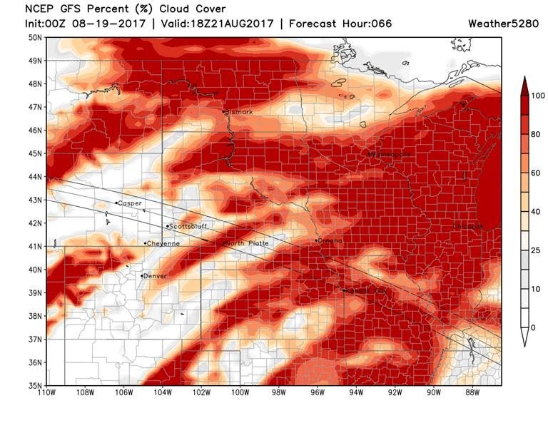
A Map Version of Cloud Forecasts
These maps were created by www.weather5280.com (you should visit them for weather discussion as well!). These maps are a cloud forecast map (future satellite image, sort-of) with percent cloud cover plotted and the eclipse path added for reference by those talented forecasters and programmers. All of these are for the same time and date – noon on Monday, Mountain Time, near totality of the eclipse. As with the table above, keep an eye on the trends and patterns. If they change a lot day to day, confidence is low that the models are getting it right. If they are consistent, then you can place some confidence in this forecast. This is a different model than the one creating the percentage table above, so if these numbers match those, you can be even happier that you know what Monday will be like. Never allow yourself to be completely confident that this is what Monday will yield.
Saturday commentary: the model is creating, not only new color output, but a sharp increase in expected clouds for all of Nebraska and parts of Wyoming. This is a sudden departure of the previous trend. You might want to consider Wyoming over Nebraska based on this.
Forecast created Sunday 8/13

Forecast created Monday 8/14


Forecast created Tuesday 8/15

Forecast created Wednesday 8/16

Forecast created Thursday 8/17

Forecast created Friday 8/18

Forecast created Saturday 8/19 Note change of coloration- blue is clear, dark grey is cloudy. Something changed in this model output in the last day.

*** This feature will run as close to daily as possible in this location on the Longmont Observer. ***
This article will provide a brief discussion concerning the ‘why’ behind the weather with a focus on severe weather, unusual weather, and snow (especially trying to predict snow depth and its human impact in Longmont).
Bio:
John Ensworth works from Longmont as the Principle Investigator for the NASA Science Mission Directorate Earth and space science education product review through the IGES (The Institute for Global Environmental Strategies – www.strategies.org) . He is in his 14th year running this review. He is an astronomer (from the 2nd grade onward) and became a meteorologist (in the 5th grade) when a thunderstorm in Arizona rained on his telescope when the weather service had only forecasted a 10% chance of rain. He has college degrees in physics and astronomy and climatology and a graduate degree in meteorology and earth science. He lectures at the Little Thompson Observatory in Berthoud, the Estes Park Memorial Observatory in Estes Park, and for a number of online universities. He built and runs a backyard observatory near Pace and 17th in northeast Longmont where he has lived for 8 years with his wife, daughter, son, and two cats. Invitations to open house nights at this observatory, LTO, and EPMO will be posted with future discussions when they are scheduled.
Forecasting severe weather and snow amounts via text lead to this column. He began texting friends about the weather right after the September 2013 flood. The readers of this column will, hopefully, keep him honest in what he ‘thought’ he had forecasted for ‘the most recent’ storm.


