This content was originally published by the Longmont Observer and is licensed under a Creative Commons license.
Issued: Wednesday July 12, 2017
By John Ensworth
This feature will run as close to daily as possible in this location on the Longmont Observer.
This article will provide a brief discussion concerning the ‘why’ behind the weather with a focus on severe weather, unusual weather, and snow (especially trying to predict snow depth and its human impact in Longmont).
Discussion:
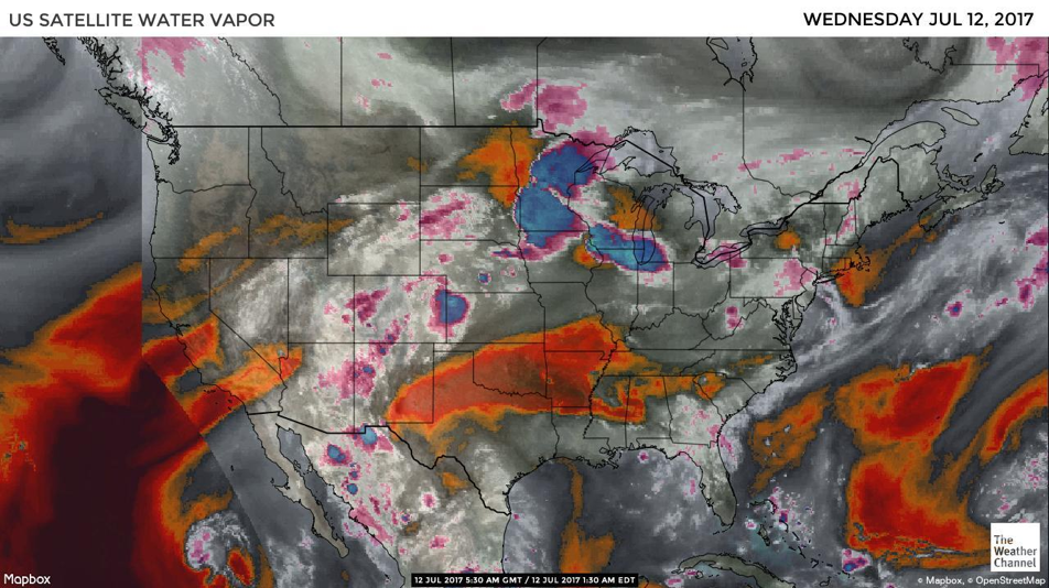
Our summer staring ridge has flattened and has allowed moisture up into the state (see the water vapor image sequence below). Arizona, Utah, and Western Colorado still get the best chances of rain/thunderstorms, but, with a very weak front pushing down, we’ll have some enhanced upslope flow moving more moisture westward into the Foothills. The Storm Prediction Center in Norman, OK has issued a Marginal Risk (1 on a scale of 1 to 5, with 5 being the most severe and dangerous) of severe weather for areas near I-25 and eastward. Longmont is *just* outside of the risk zone, but not by much. Storms that form this afternoon will create possibly damaging hails and winds. (Tornadoes are unlikely). I’m keeping with my forecast that the best chance of rain will be this afternoon and Thursday afternoon as the monsoon flow is at its best for a couple of days.
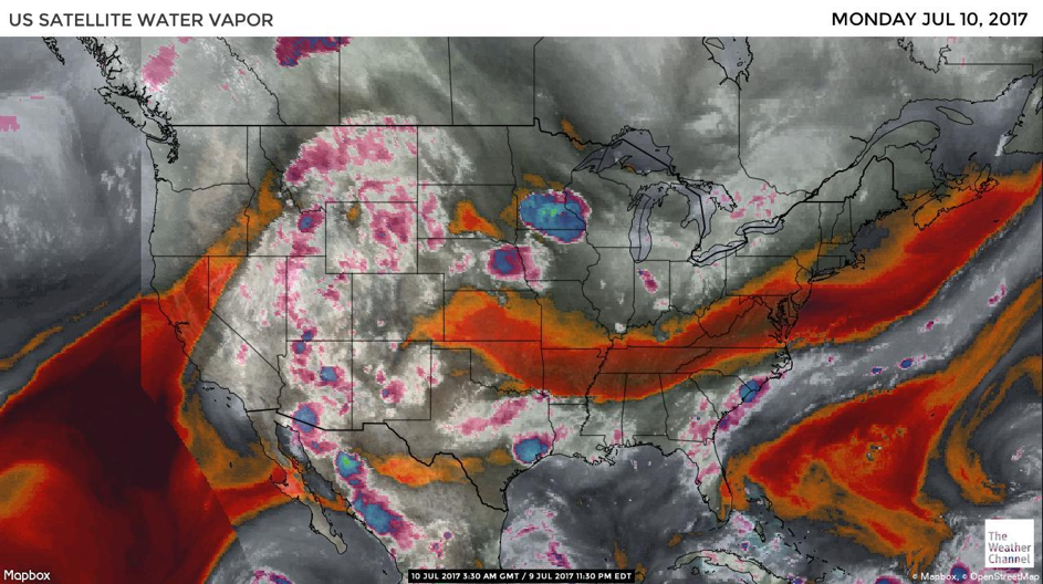
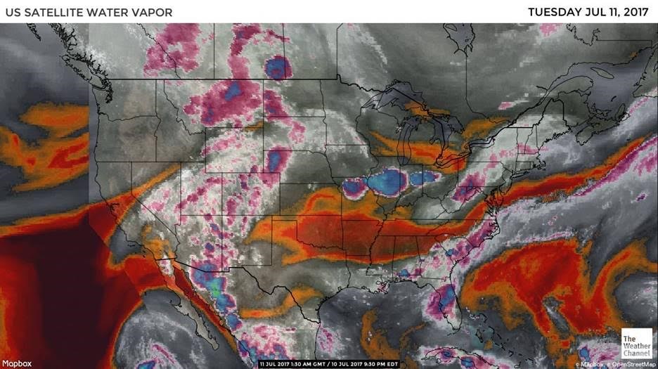
Today is day 3 of our moisture-flow-watch associated with this first hit of the summer monsoon. In the images below (taken Sunday night, Monday night, and Tuesday night locally) we see the water vapor image from the Weather Channel’s Website. As described in this series, the satellite is looking at frequencies of light emitted by the Earth that are absorbed by moisture in the atmosphere. The deep red and orange colors are places where the atmospheric moisture content is very low from the surface up to the top of the troposphere. The grey areas have some moisture. The white and pink regions have a high moisture content.
You can see that the feed of moisture across the southern US on into Texas, New Mexico, and up into western Colorado and a flow out of Mexico has now combined into one thread pushing up into the southern Rockies. The colors over Colorado show that our state is now under the center of the moisture flow, but only after it has created showers in Mexico, Texas, New Mexico, Arizona and Utah first.
An interesting note, you can see Tropical Storm Eugene just off the bottom edge toward the left corner of the image in the eastern Pacific. Now it appears that its moisture is contributing to the Mexico flow.
In a look at the longer range: we know that the ridge will expand back to the west next weekend, but with moisture in place, the mountains will continue to receive more afternoon thunderstorm activity than we have yet seen this summer. A surge of moisture from that tropical system may reach Colorado on Saturday and kick up our rain chances for an evening. We don’t return to the mid 90’s again until Mondayas the air dries out and the ridge strengthens again.
Bio:
John Ensworth works from Longmont as the Principle Investigator for the NASA Science Mission Directorate Earth and space science education product review. He is in his 14th year running this review. He is an astronomer (from the 2nd grade onward) and became a meteorologist (in the 5th grade) when a thunderstorm in Arizona rained on his telescope when the weather service had only forecasted a 10% chance of rain. He has college degrees in physics and astronomy and climatology and a graduate degree in meteorology and earth science. He lectures at the Little Thompson Observatory in Berthoud, the Estes Park Memorial Observatory in Estes Park, and for a number of online universities. He built and runs a backyard observatory near Pace and 17th in northeast Longmont where he has lived for 8 years with his wife, daughter, son, and two cats. Invitations to open house nights at this observatory, LTO, and EPMO will be posted with future discussions when they are scheduled.
Forecasting severe weather and snow amounts via text lead to this column. He began texting friends about the weather right after the September 2013 flood. The readers of this column will, hopefully, keep him honest in what he ‘thought’ he had forecasted for ‘the most recent’ storm.


)