
This content was originally published by the Longmont Observer and is licensed under a Creative Commons license.
By John Ensworth
Discussion:
The severe weather, including golf ball sized hail west of Ft. Collins (as of 9pm Thursday, there were 18 hail reports and 4 severe wind reports, and one tornado warning), marked another wet day for many on Thursday. A front pushed down against the mountains and well timed (see yesterday’s discussion) short waves made the Marginal Risk come true. Figure 1 shows that front and some remaining severe weather far to the southeast of Longmont going on where an Enhanced Risk was posted (3 on a scale of 1-5).
Figure 1: Surface frontal analysis, pressure centers and radar from Wunderground.com.
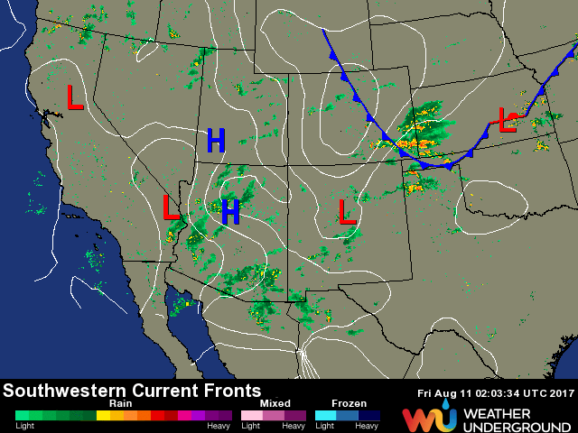
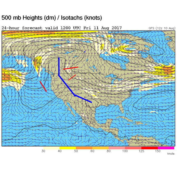
Figure 2 shows the mean ridge position and how it has inched yet closer to Colorado. The red lines show the short waves that will enhance thunderstorm activity as they travel down the flow.
Figure 2: The 500mb map forecast for Friday morning from the GFS model.
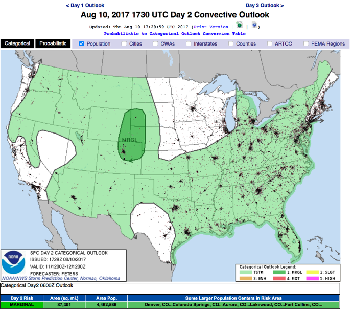
With the shortwaves coming, more heat with the ridge approaching, and the front nearby, severe weather is still expected for Longmont and the Front Range Friday. It is again a Marginal Risk – a 1 on a scale of 1-5 issued by the Storm Prediction Center in Norman, Oklahoma (the SPC) – again mainly for supercell related large hail and damaging winds. Soils are wetter, so always be aware that local flooding may occur under the bigger storms – Figure 3.
Figure 3: The SPC forecast Day 2 for Friday issued on Thursday.
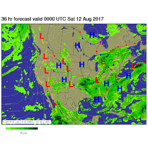
Friday afternoon, the front is draped right down the I-25 corridor with moisture in place and thunderstorms firing off in the mountains and traveling southeast into the cities – see Figure 4.
Figure 4: The NCEP surface analysis forecast for Friday night.
In a look at the longer range:
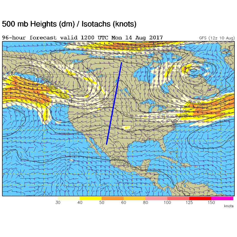
Still, nothing major really changes through the weekend except the ridge keeps inching closer warming us up, and drying us out a bit. Figure 5 shows the ridge passing overhead on Monday, but the lower level atmosphere is not expected to completely dry out. Things will be somewhat warmer and drier, but still cooler than normal. Beyond Monday – we may set up for monsoon flow again. Bye bye drought and fire danger!
Figure 5: The Monday morning upper air pattern, 500mb GFS forecast. The ridge is drawn in blue.
*** This feature will run as close to daily as possible in this location on the Longmont Observer. ***
This article will provide a brief discussion concerning the ‘why’ behind the weather with a focus on severe weather, unusual weather, and snow (especially trying to predict snow depth and its human impact in Longmont).
Bio:
John Ensworth works from Longmont as the Principle Investigator for the NASA Science Mission Directorate Earth and space science education product review through the IGES (The Institute for Global Environmental Strategies – www.strategies.org) . He is in his 14th year running this review. He is an astronomer (from the 2nd grade onward) and became a meteorologist (in the 5th grade) when a thunderstorm in Arizona rained on his telescope when the weather service had only forecasted a 10% chance of rain. He has college degrees in physics and astronomy and climatology and a graduate degree in meteorology and earth science. He lectures at the Little Thompson Observatory in Berthoud, the Estes Park Memorial Observatory in Estes Park, and for a number of online universities. He built and runs a backyard observatory near Pace and 17th in northeast Longmont where he has lived for 8 years with his wife, daughter, son, and two cats. Invitations to open house nights at this observatory, LTO, and EPMO will be posted with future discussions when they are scheduled.
Forecasting severe weather and snow amounts via text lead to this column. He began texting friends about the weather right after the September 2013 flood. The readers of this column will, hopefully, keep him honest in what he ‘thought’ he had forecasted for ‘the most recent’ storm.


