Skip to content
Join our Newsletter

Friday Update: The Front Range Forecast: Cold rain and warm snow

The Friday forecast update:

Here comes another storm! The big difference with this next storm is that there will be a lot more moisture (some falling as just rain) and much warmer temperatures.

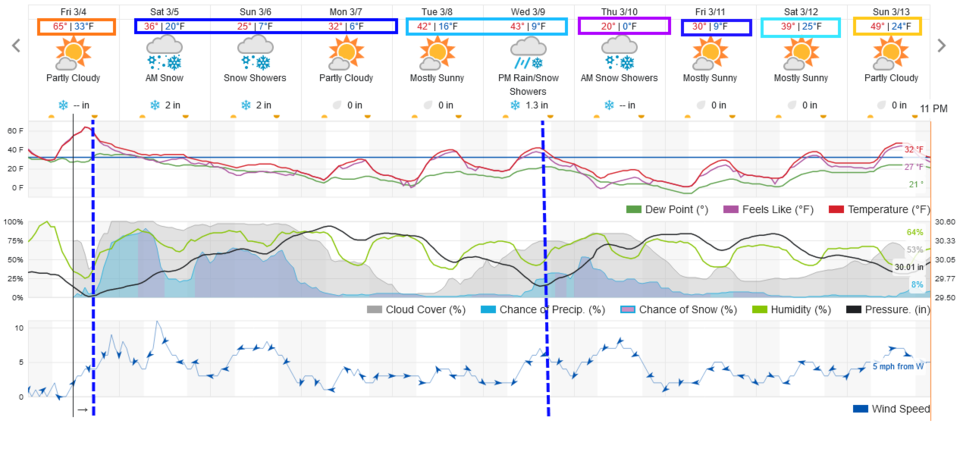
The snow begins today in the mountains, rain begins tonight on the lowlands (it won't be down to the middle 30s along I-25 until the predawn hours Figure 1 update). Rain will change to snow before dawn but will be pretty wet/slushy. We may have a rain/snow mix Saturday morning. With the warmer ground, most snow will accumulate, at first, on grassy surfaces and bridges. The lower elevations should see 0.75-1 inch of water (rain ans snow melt) over the weekend.

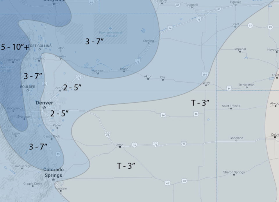
The mountains should receive 1-1.5 inches of water. Sunday will see colder temperatures and the snow should stick better. Because of the marginal temperatures Saturday and wet conditions, I'm going to broad-brush snow totals. From Fort Collins to east Denver, expect 0.5-2 inches Saturday and 1-3 on Sunday, ending after midnight Sunday/Monday.

The lower foothills (Castle Rock to Golden to Boulder to west Fort Collins): 1-3 Saturday and 2-4 on Sunday. The higher foothill communities (Nederland to Estes Park to Red Feather Lakes): 1-3 inches Friday night, 2-4 inches Saturday, 2-4 inches Sunday.  The forecasters at Weather 5280.com give the I-25 corridor folks 3-7 inches (I'm guessing more Saturday afternoon to late Sunday night when colder air arrives).

Another, briefly very cold (Thursday), snowstorm hits Wednesday/Thursday with 1-3 inches in the lowlands, 2-5 inches for the mountains. (Figure 1 update.)

Figure1_03042022
Figure 1 update: the 10 day graphical weather forecast from weather5280.com


Figure2_03042022
Figure 2 update: the hand-drawn snowfall forecast from the forecasters at weather5280.com for the entire weekend.


About the Author: John Ensworth

John Ensworth used to work from Longmont as the PI for the NASA through the IGES (The Institute for Global Environmental Strategies). He now teaches technology, algebra, astronomy, meteorology, film school, and Lego robotics to middle/high school.
Read more


Comments


Current Weather

Clear

Clear

60°F

UV Index
0 Low
Pressure
30.06 Rising
Visibility
8 miles
Dewpoint
46 °F
Humidity
58%
Wind
SW 1.8 mph
Gust
3.8 mph
Wind Chill
60 °F

Hourly Forecast

Today
10 PM
59°F
Mostly clear
Today
11 PM
58°F
Mostly clear
Tomorrow
12 AM
56°F
Mostly clear
Tomorrow
1 AM
55°F
Mostly clear
Tomorrow
2 AM
54°F
Mostly clear
Tomorrow
3 AM
53°F
Clear
Tomorrow
4 AM
52°F
Clear
Tomorrow
5 AM
51°F
Clear
Tomorrow
6 AM
50°F
Clear
Tomorrow
7 AM
53°F
Sunny
Tomorrow
8 AM
57°F
Sunny
Tomorrow
9 AM
63°F
Sunny

7 Day Forecast

Partly sunny w/ showers

Sunday

73 °F

Brief morning showers; otherwise, clouds giving way to some sun


Clear

Sunday Night

49 °F

Clear


Partly sunny w/ t-storms

Monday

86 °F

Partly sunny and warmer; a thunderstorm around in the afternoon


Partly cloudy

Monday Night

52 °F

Partly cloudy


Partly sunny w/ t-storms

Tuesday

72 °F

Times of clouds and sun with a thunderstorm around in the afternoon


Mostly cloudy

Tuesday Night

50 °F

Increasing clouds


Mostly cloudy w/ t-storms

Wednesday

67 °F

Some sun, then turning cloudy with a couple of thundershowers in the afternoon


Clear

Wednesday Night

50 °F

Clear


Mostly sunny

Thursday

75 °F

Mostly sunny and pleasant


Clear

Thursday Night

47 °F

Clear


Sunrise and Sunset

Sunrise
6:40 AM
Sunset
7:11 PM

Based on AccuWeather data