Skip to content
Join our Newsletter

Wed update: Front Range Forecast: Snow totals, warming up mostly

In Brief:

A slow warm-up except for a very cold Friday.

Wednesday Update.

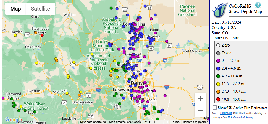
Widespread heavy snow hit the mountains with this long duration storm/cold spell (Figure 1 update). The yellow dots are 1-2 feet with a location near Steamboat Springs getting around 3.5 feet! Along I-25 it was still a fair amount of snow with widespread 2-5 inch totals.

We have more mountain snow coming Wednesday/Thursday.  Friday will be briefly very cold again (20's for a high). Then we move into a longer dry period and warm-up.

figure1u01172023
Figure 1 update: the CoCoRaHS snow totals map.

End Wednesday update.

Forecast Discussion:

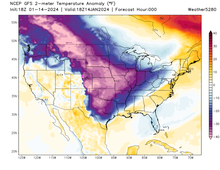
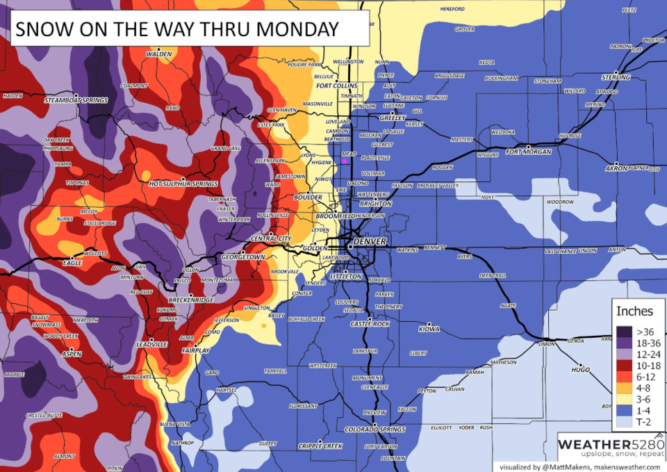
The news, nationwide, has been how remarkable and widespread the cold air and snow has been.  We have about two days left of the deep freeze locally, then the cold air will slosh out to the southeast (Figure 1). We also have another shot of snow, bringing about 1-4 inches to I-25 folks and 3-5 inches for the Foothills, and a foot or two for the higher elevations (Figure 6).

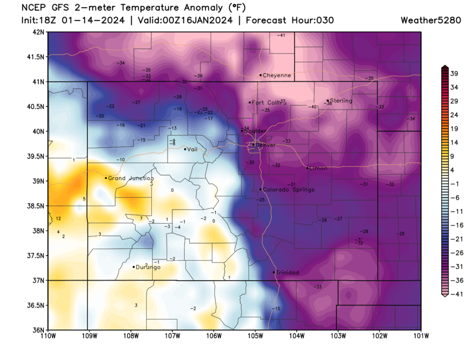
The cold air on Sunday is still spreading to the south and east across the nation (Figure 2, purples). The peak cold air will push in Monday evening (Figure 3).

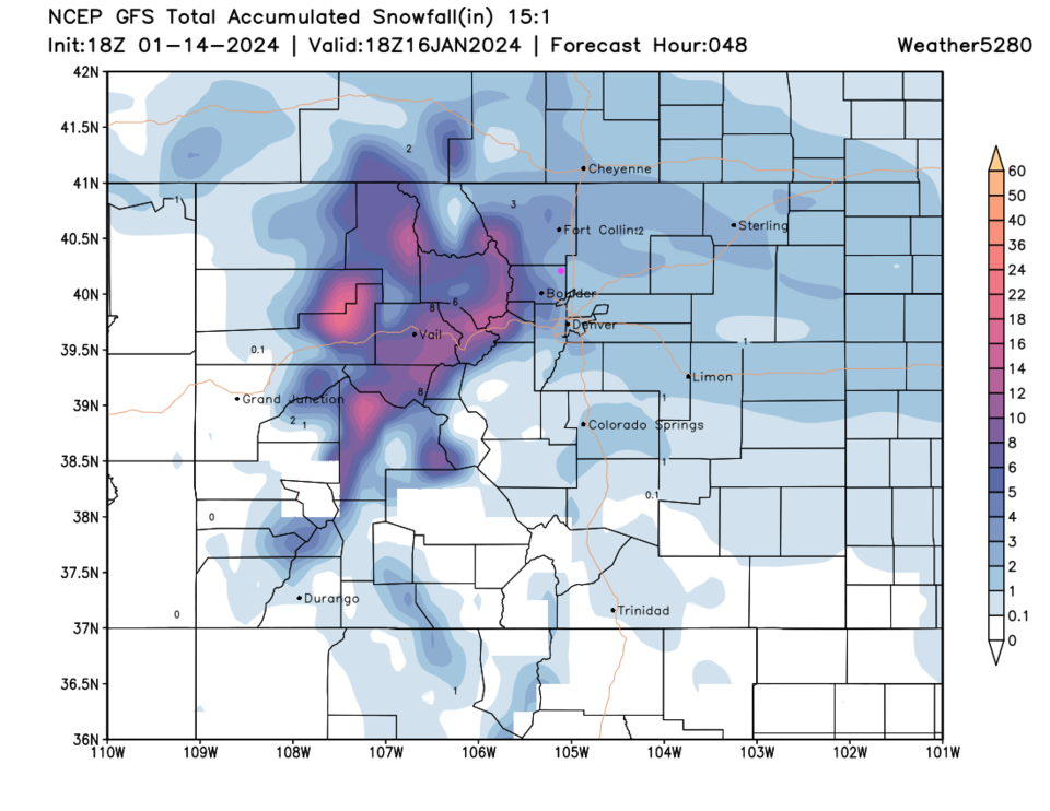
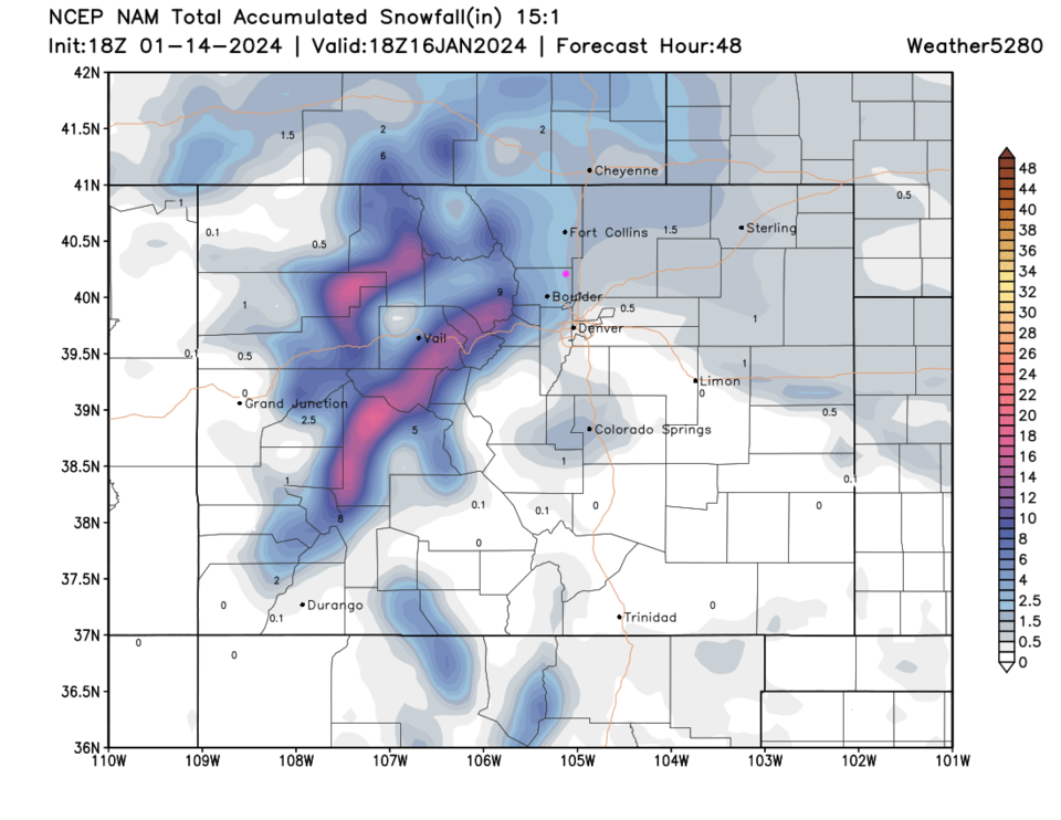
The GFS gives Longmont 2-3 inches of new snow between 4am and 5pm Monday (Figure 4). The NAM also gives us 2-3 inches (Figure 5).

Matt M. at weather5280 puts Longmont in the 1-4 inch zone (Figure 6).

figure_01142024
Figure 1: the 10 day graphical forecast for Longmont from weatherunderground.com
figure2_01142024
Figure 2: the US-wide view of surface temperature anomalies (departure from from normal for this day and time) for Sunday at noon from the GFS and weather5280.com
figure3_01142024
Figure 3: the CO-wide view of surface temperature anomalies (departure from from normal for this day and time) for Monday PM at noon from the GFS and weather5280.com
figure4_01142024
Figure 4: the 15:1 snowfall forecast for the next 48 hours from the GFS and weather5280.com
figure5_01142024
Figure 5: the 15:1 snowfall forecast for the next 48 hours from the NAM and weather5280.com
figure6_01142024
Figure 6: the snowfall forecast from Matt Makens at weather5280.com for the Monday storm.

The Longer Range Forecast:

Looking back at Figure 1 - we finally climb above freezing Wednesday with a brief chill Thursday PM and Friday with a small snow chance. Welcome to Colorado winters!


About the Author: John Ensworth

John Ensworth used to work from Longmont as the PI for the NASA through the IGES (The Institute for Global Environmental Strategies). He now teaches technology, algebra, astronomy, meteorology, film school, and Lego robotics to middle/high school.
Read more


Comments


Current Weather

Cloudy

Cloudy

46°F

UV Index
0 Low
Pressure
30.28 Rising
Visibility
8 miles
Dewpoint
43 °F
Humidity
88%
Wind
N 1.2 mph
Gust
3.3 mph
Wind Chill
46 °F

Hourly Forecast

Today
11 PM
45°F
Showers
Tomorrow
12 AM
44°F
Mostly cloudy w/ showers
Tomorrow
1 AM
43°F
Mostly clear
Tomorrow
2 AM
42°F
Mostly clear
Tomorrow
3 AM
41°F
Mostly clear
Tomorrow
4 AM
40°F
Mostly clear
Tomorrow
5 AM
40°F
Mostly clear
Tomorrow
6 AM
39°F
Mostly sunny
Tomorrow
7 AM
42°F
Mostly sunny
Tomorrow
8 AM
47°F
Mostly sunny
Tomorrow
9 AM
52°F
Mostly sunny
Tomorrow
10 AM
56°F
Mostly sunny

7 Day Forecast

Thunderstorms

Wednesday

55 °F

Low clouds and cool; rain and drizzle this morning, then afternoon thunderstorms


Partly cloudy w/ showers

Wednesday Night

39 °F

A passing shower or two this evening; otherwise, clearing


Partly sunny

Thursday

70 °F

Partly sunny, pleasant and milder


Mostly clear

Thursday Night

42 °F

Mainly clear


Thunderstorms

Friday

72 °F

Mostly cloudy with a thunderstorm in spots in the afternoon


Mostly clear

Friday Night

45 °F

Clear to partly cloudy


Mostly sunny

Saturday

78 °F

Sunny to partly cloudy and nice


Clear

Saturday Night

44 °F

Clear


Mostly cloudy

Sunday

79 °F

Mostly cloudy


Mostly clear

Sunday Night

50 °F

Mainly clear


Sunrise and Sunset

Sunrise
5:53 AM
Sunset
8:01 PM

Based on AccuWeather data