In Brief:
Very cold air flows in as the snow departs.
Wednesday update:
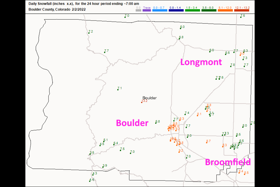
The winter storm warning has been downgraded to a winter weather advisory. The last inch or two will fall by 7pm. Figure 2 update shows that 5 to 9 inches of snow fell across Longmont. Broomfield picked up 6.5 to 8.7 inches. Boulder topped out at 11 inches. Temperatures may approach -10F along I-25 tonight and not warm much on Thursday. We won't see temperatures above freezing until Friday. It will warm to around 38F.
End Wednesday update.
Tuesday AM Update:
The National Weather Service has issued the following Winter Storm Warnings for the lower elevations and the higher elevations of the Front Range. This does not include Denver but areas north of the metro. They have switched to an inch above my forecast range from last night.
Winter Storm Warning (Along I-25)
Issued: 2:32 AM Feb. 1, 2022 – National Weather Service
...WINTER STORM WARNING IN EFFECT FROM 5 PM THIS AFTERNOON TO
MIDNIGHT MST WEDNESDAY NIGHT...
* WHAT...Heavy snow expected. Total snow accumulations 7 to 11
inches.
* WHERE...Fort Collins, and Boulder and the western suburbs of
Denver.
* WHEN...From 5 PM this afternoon to Midnight MST Wednesday Night.
* IMPACTS...Snow covered roads will make travel hazardous. Travel
may become very difficult due to heavy snowfall on roadways. Plan
on slippery road conditions. The hazardous conditions may impact
the Tuesday evening and will impact the Wednesday morning commutes.
Winter Storm Warning (The Mountain Communities)
Issued: 2:32 AM Feb. 1, 2022 – National Weather Service
...WINTER STORM WARNING IN EFFECT FROM 2 PM THIS AFTERNOON TO
MIDNIGHT MST WEDNESDAY NIGHT...
* WHAT...Snow expected. Total snow accumulations 7 to 14 inches.
Winds gusting up to 30 mph.
* WHERE...The Front Range Foothills.
* WHEN...From 2 PM this afternoon to Midnight MST Wednesday Night.
* IMPACTS...Snow covered roads will make travel hazardous. Travel
may become very difficult due to heavy snowfall on roadways.
End Tuesday AM update.
Monday update:
The fronts are on their way. Cold air will arrive tonight with highs around freezing Tuesday. Then colder air arrives and will give I-25 folks highs in the mid to upper teens and lows in the mid-negative-single digits. The mountains stay a touch warmer except Wed/Thur when the cold climbs that high.
The snow should begin to hit the urban corridor around 4pm Tuesday and continue until it starts to taper off 10pm Wednesday. I'm going to go a bit *above* the NWS totals and local outlet totals (included below) because of the duration of the event and higher snow totals one sees with colder temperatures (powder vs. pack-able snow, or 15:1 snow to moisture ratio vs. the normal 10:1 ratios best closer to freezing). Sticking my neck out a bit.
There is a winter weather advisory for much of the state at this time (also included below). Travel will be difficult Wednesday morning. IF the higher snow totals materialize, travel Thursday will be tricky in neighborhoods even if snow plows have cleared main roads (they'll have about 6-9 hours to clear things off in sub-zero temperatures).
Snowfall Roundup
My Longmont to Broomfield total: 6-9"
Channel 7: 3-6" along the Front Range 6-10" in mountains.
NWS: there is good agreement for the best accumulations to be in the foothills with best chances in the northern foothills. Can see a range of 6-12" in those areas followed by 4-7" in the urban corridor with better chances for higher amounts further west. 2-6" can be expected over most of the eastern plains.
Channel 9: urban corridor 4-6”, mountain communities 6-9”, on the Plains 2-4”
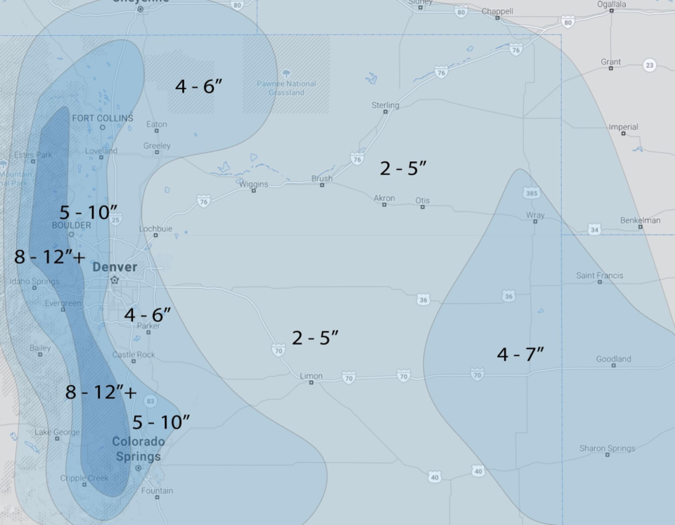
Weather5280.com forecasters: 5-10" along I-25, 4-6" east of I-25, 8-12+ Estes Park to RMMP and south at that elevation. 2-5" out on the Plains.
WINTER WEATHER ADVISORY IN EFFECT FROM 5 PM TUESDAY TO MIDNIGHT MST WEDNESDAY NIGHT...
* WHAT...Snow expected. Total snow accumulations 4 to 7 inches.
* WHERE...Portions of central, north central, and northeast Colorado.
* WHEN...From 5 PM Tuesday to Midnight MST Wednesday Night.
* IMPACTS...Plan on slippery road conditions. The hazardous
conditions could impact the Tuesday evening and Wednesday commutes.
The weather5280.com forecasters released their forecast map in Figure 1 update. They are closer to my expectations. I'm frankly unable to explain the TV outlets and NWS's lower values. The proof will be in the meteorological pudding come Thursday morning.
End Monday update.
Forecast Discussion:
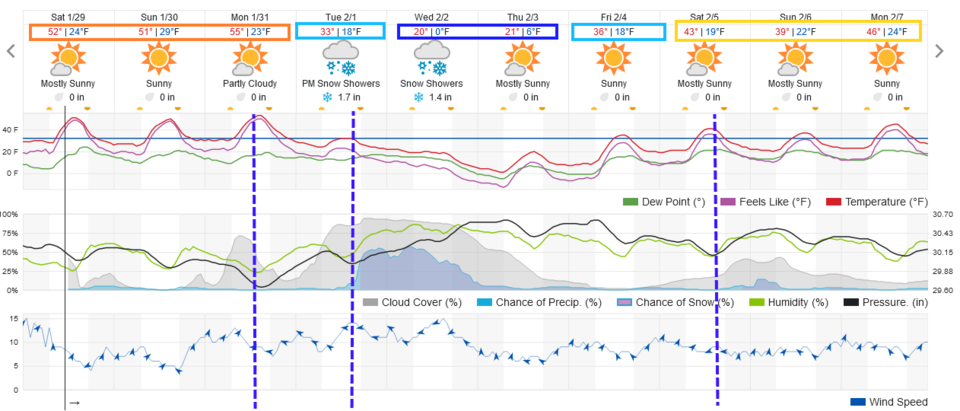
We will enjoy a beautiful weekend with temperatures in the 50s and dry conditions (Figure 1). Maybe we can get rid of some icy spots before ...
The Longer-Range Forecast:
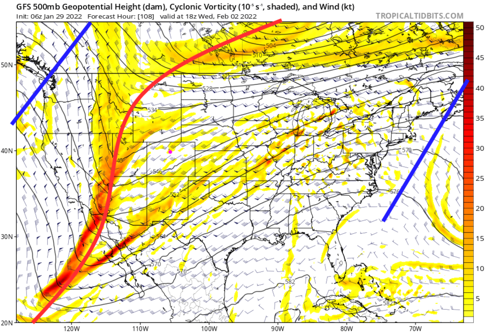
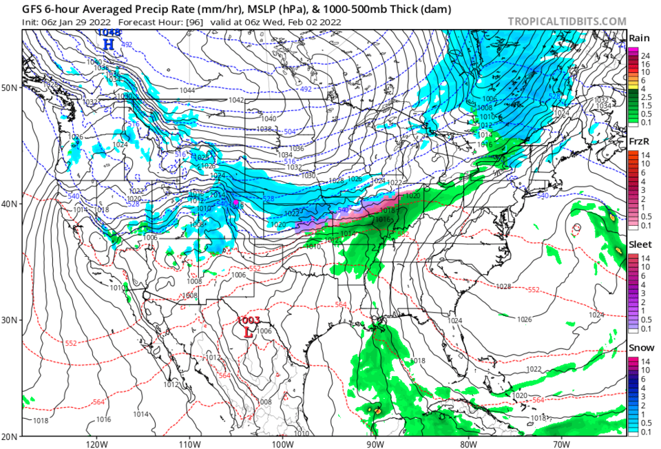
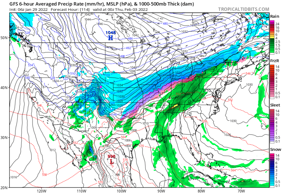
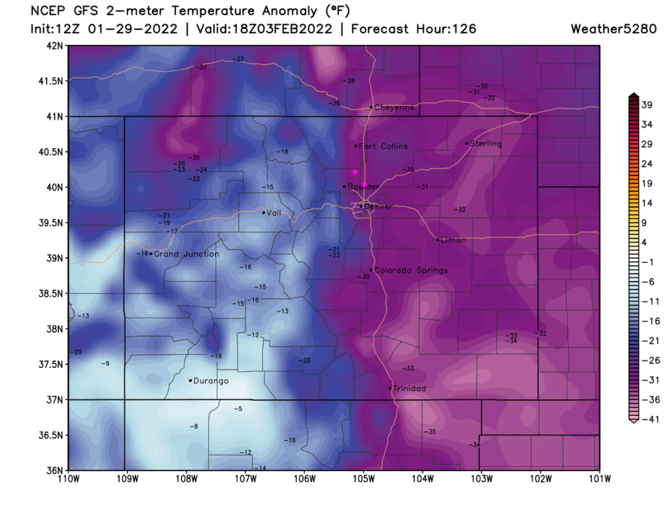
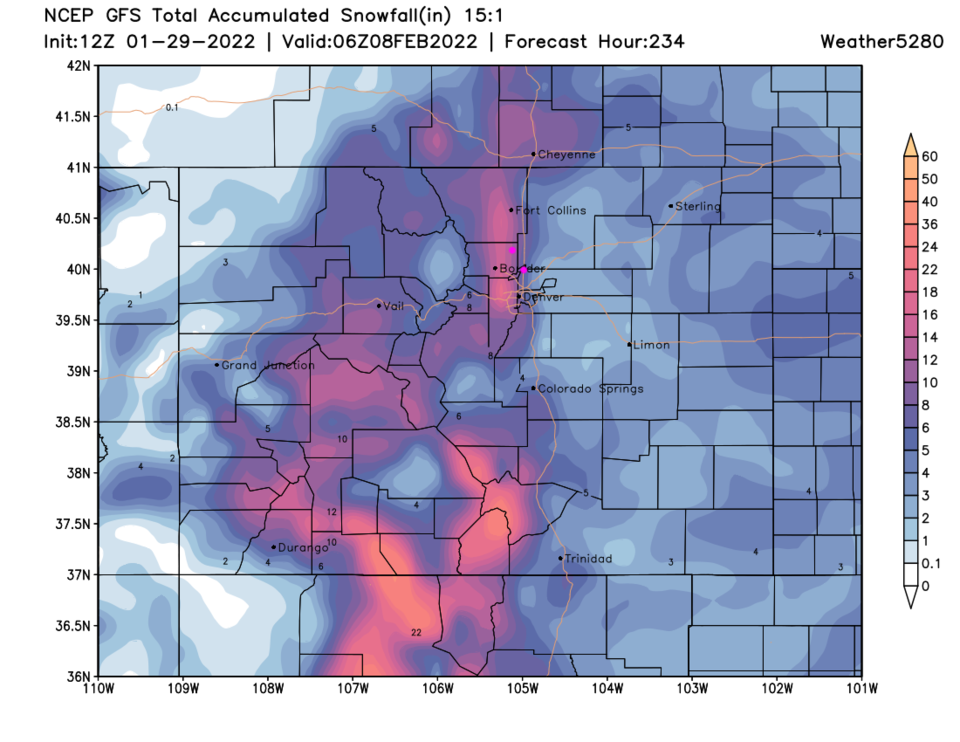
A large powerful trough will sweep into the nation bringing bitterly cold air and an extended period of snow (Figure 2). Our first cold front arrives around 1 pm on Monday beginning the cooldown. Another punch Tuesday afternoon begins the precipitation around 5 pm on Tuesday. Snow should continue until around 8 pm on Wednesday (Figure 1). This is a large slow-moving shield of snow (Figure 3 and Figure 4). Wednesday night, temperatures may sink into the negative digits and will be around 30 degrees below normal (Figure 5).
I'll return with a snowfall roundup as we get closer to the storm, but with higher snow ratios (due to the colder temperatures and expected vertical temperature profile during storm-time) The GFS gives areas along I-25 around 8-10 inches with 1-1.5 feet totals in the nearby foothills. Sounds like a 'snow day' or two to me!