In Brief:
We start this period with two days of cool wet weather, then settle into a long warm (but not hot) stretch of comfortable temperatures.
Update 6/19 12pm:
The first batch of rainfall set up a "training" scenario over Boulder county giving us more rain than most of the region. Boulder got close to 1 inch of water overnight while Longmont hovered between 1/2 and 2/3rds of an inch (Figure 1 update). The HRRR model has a line of storms forming and hitting in the early to mid afternoon today/Friday (Figure 2 update). Be ready for some lightning and small hail. The Marginal Risk of severe weather has NOT been extended up to Longmont and areas north (as I predicted) but a Slight risk (2 out of the 1-5 scale) has been added south and east of Colorado Springs.
End update 6/19 12pm.
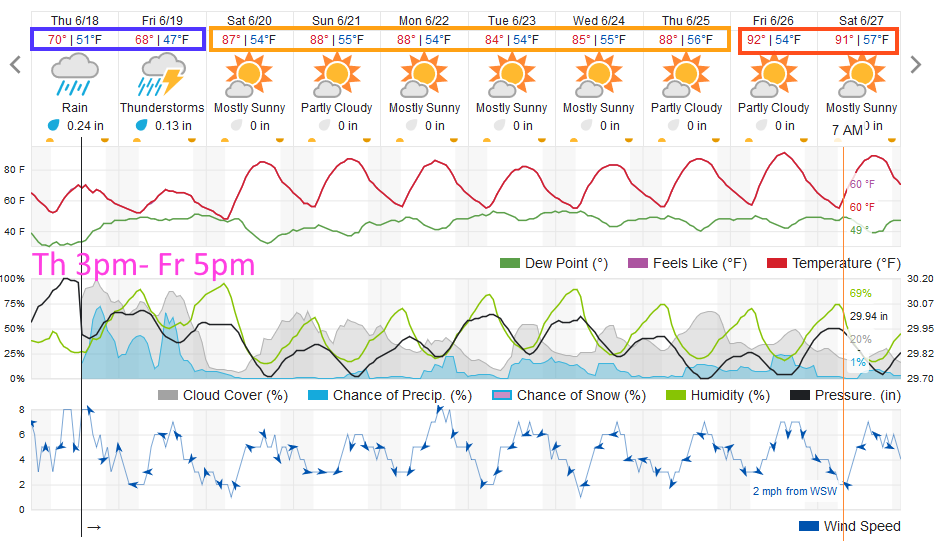
Forecast Discussion:
There are showers moving in as I type. We should see unsettled, somewhat wet, weather from about 3pm Thursday to 5pm Friday (Figure 1 in the gallery). The weatherunderground model in this figure shows three periods of enhanced shower chances. The GFS (Figure 2) shows two, mainly afternoon and evening, rainy periods. Temperatures are remarkably cool (and nice for my running - Figure 1 again).
By Friday evening, the front has pushed far south of the state with moisture flowing westward over the cool air generating rain on the eastern plains and in the mountains (Figure 3). There is a marginal risk of severe weather (hail and high winds) from Denver southward as this post goes up. I expect they will expand this northward along the Front Range tomorrow (Figure 4).
The weatherunderground.com model gives us under 1/2 inch of rain over the next 36 hours or so (Figure 1). The GFS agrees with 0.25-0.5 inch of water over the next 5 days (Figure 5).
The front is pushing most of the smoke from Arizona and SW Colorado forest fires down to the south Thursday (Figure 6). Sadly, it will return quickly on strong southwest winds aloft on Friday (Figure 7).
The Longer Range Forecast:
The trough giving us the showers, cold front, and rain moves on to the east on Saturday (Figure 8) beginning another warm up. The long range temperatures remain seasonable and don't rise to the 90'sF I called for in recent forecasts (Figure 1) since the ridge in the west is expected to remain further to the west than thought earlier (Figure 9). We'll have northwest flow aloft and might see a small afternoon storm now and then all week. Oh the wonders of northwest flow.


