In Brief:
Heat with daily afternoon (sometimes a bit strong) thunderstorms will be the story for the next week except for a Tue/Wed cool down and better chance of storms for a day.
Forecast Discussion:
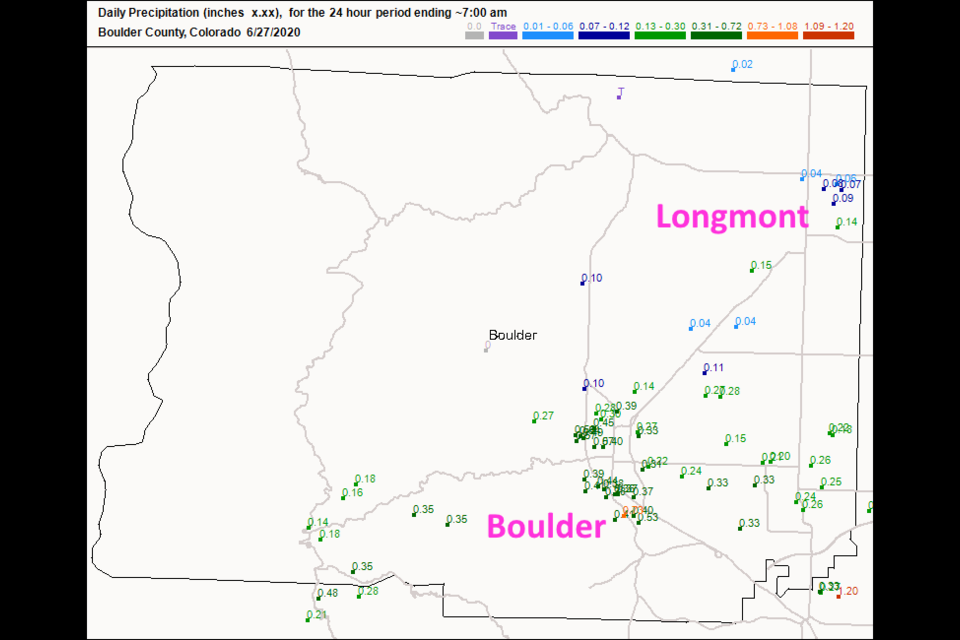
Longmont was mostly skipped by the storms and rainfall Friday. The rainfall totals across town were around 1/10th of an inch on average (Figure 1 in the gallery above). Boulder received about 1/3rd to 1/2 inch overall. There were many storms in northern Colorado, but a monster storm formed west of Castle Rock and drifted southeast towards Colorado Springs (Figure 2). It did have a tornado warning on it with a velocity couplet visible on radar inside, but no tornado was reported. There were many hail reports (circled in red Figure 3) and over an inch was recorded where it tracked.
On Saturday, we have another short wave trough coming in from the west (Figure 3) while we sit in the center of an overall large ridge (giving us the heat/90'sF). We still have moisture around. This moisture plus really warm air and that short wave will give us a marginal risk of severe weather from I-25 eastward for hail and high winds in the few, widely separated, storms that form (Figure 4).
On Sunday, a short wave ridge will enhance the heat a bit as this trough departs. The southwest flow aloft (Figure 5) will transport a little bit of smoke and haze up into the state Sunday (Figure 6) but the overall flow from the west and an apparent decrease in fire intensity in Arizona will result in clearer skies Monday (Figure 7).
The Longer Range Forecast:
After roasting in the 90's through Monday we do have a cool down Tuesday and Wednesday to the 80'sF and have a better chance of showers/storms on Tuesday (Figure 8). This change mid-week is caused by a larger trough approaching and passing the state (Figure 9). Storms for the next 5 days will be scattered and many spots will not see any rain (Figure 10). Other locations near I-25 will get less than 1/10th of an inch on average. That lucky storm or two may really dump some water, but you will have to win the "thunderstorm lottery" to see much water fall.
Independence Day:
We will have a big ridge over most of the U.S. for Independence Day with high in the lower 90'sF and a fair chance of an afternoon thunderstorm. Summer and typical 4th of July weather.


