Skip to content
Join our Newsletter

Longmont Weather Forecast 7/30-31/2020

In Brief:

Slightly better storm chances are slated for Thursday before a big western ridge returns us to only small afternoon storm chances.

Forecast Discussion:

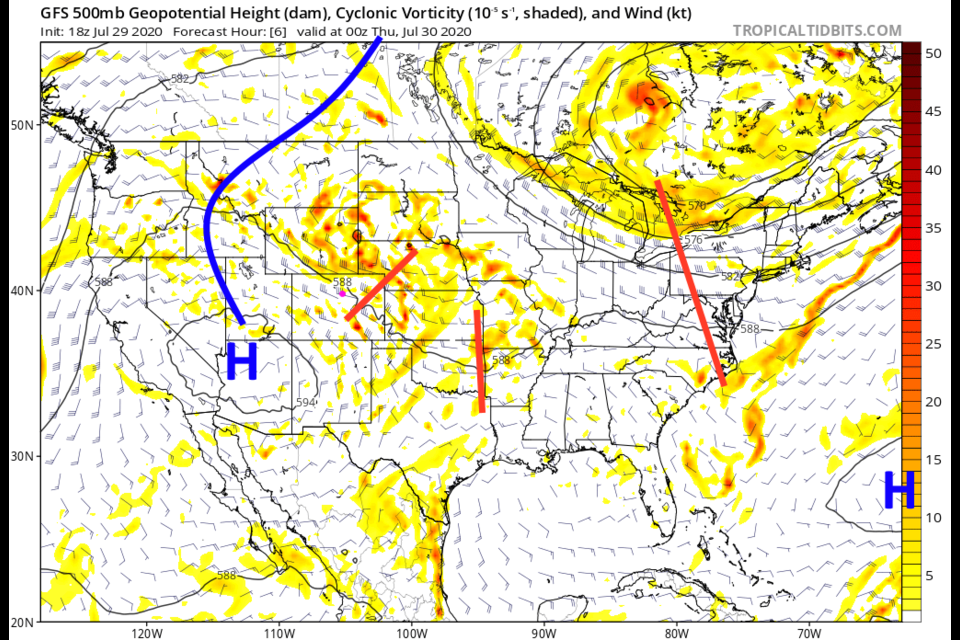
One more short wave passes Thursday giving us better storm chances (Figure 1 in the gallery above). The ridge to the west with a high center over NW Arizona is about to grow! The moisture for Thursday is having to travel pretty far from the Gulf to get to us, but it will for one more day (Figure 2). This northwest flow is bringing a bit of haze and smoke in with the moisture (Figure 3) but it isn't very thick this time.  Note, severe weather is not expected around Longmont at this time. A nice feature to this pattern is that there is a strong northern component to the air flow into the state, so we won't see abnormally warm temperatures until maybe next week (Figure 4).

Rainfall over the next 48 hours should be quite minimal and confined to the I-25 corridor overall (Figure 5).

The Longer Range Forecast:

In the long term, blobs of moisture will interact with short waves in the northwest flow to give us slightly better storm chances Friday, Sunday and Tuesday afternoons (Figure 4). The eastern plains *might* get a lucky 1/2 inch or more in spots (Figure 6).  The longer term forecast is really all about the giant western U.S. ridge that will form and stay in place (Figure 7).  Again, that northern flow will keep us from seeing record high tempreatures (whew!).

In Figure 7 you can see the GFS's take on Isaias around Saturday noon.  The National Hurricane Center still expectes it to stay below hurricane status (due to the hostile enviroment it is moving through; dry air, wind shear)- but impacts might be felt across Floriday and up the east coast into next week (Figure 8).

This Week's Video Forecast!


About the Author: John Ensworth

John Ensworth used to work from Longmont as the PI for the NASA through the IGES (The Institute for Global Environmental Strategies). He now teaches technology, algebra, astronomy, meteorology, film school, and Lego robotics to middle/high school.
Read more


Comments


Current Weather

Mostly cloudy

Mostly cloudy

78°F

UV Index
0 Low
Pressure
30.04 Steady
Visibility
8 miles
Dewpoint
52 °F
Humidity
41%
Wind
SSE 5.6 mph
Gust
14.2 mph
Wind Chill
78 °F

Hourly Forecast

Today
9 PM
77°F
Intermittent clouds
Today
10 PM
75°F
Partly cloudy
Today
11 PM
72°F
Partly cloudy
Tomorrow
12 AM
70°F
Partly cloudy
Tomorrow
1 AM
68°F
Partly cloudy
Tomorrow
2 AM
66°F
Mostly clear
Tomorrow
3 AM
64°F
Mostly clear
Tomorrow
4 AM
64°F
Mostly clear
Tomorrow
5 AM
63°F
Mostly clear
Tomorrow
6 AM
63°F
Mostly sunny
Tomorrow
7 AM
64°F
Mostly sunny
Tomorrow
8 AM
69°F
Partly sunny

7 Day Forecast

Mostly cloudy w/ showers

Thursday

83 °F

Cloudy this morning with a brief shower or two, then times of clouds and sun this afternoon


Partly cloudy

Thursday Night

63 °F

Partly cloudy


Partly sunny w/ t-storms

Friday

90 °F

Partly sunny with a thunderstorm in spots in the afternoon


Partly cloudy

Friday Night

63 °F

Partly cloudy


Partly sunny w/ t-storms

Saturday

90 °F

Partly sunny with a thunderstorm in spots in the afternoon


Partly cloudy

Saturday Night

60 °F

Partly cloudy


Mostly cloudy

Sunday

93 °F

Variable cloudiness with a thundershower in spots in the afternoon


Clear

Sunday Night

59 °F

Clear


Mostly cloudy

Monday

96 °F

Mostly cloudy and very warm


Mostly clear

Monday Night

61 °F

Mainly clear


Sunrise and Sunset

Sunrise
5:45 AM
Sunset
8:28 PM

Based on AccuWeather data