Skip to content
Join our Newsletter

Longmont Weather Forecast 8/12-13/2020

In Brief:

Very hot dry weather will hold into the weekend when a subtle cool down and return of moisture begins.

Forecast Discussion:

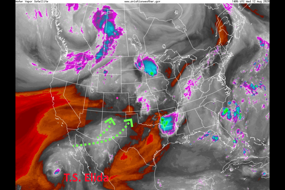
Dry air flowing in from the west will keep us very warm and dry (near record high temperatures - Figure 1).  Also in this figure you can see the dying tropical system Elida that is the first of a stream of storms that will pump moisture into the western U.S. The green arrows show the meager beginnings of this flow. Winds are from the west (Figure 2) with the giant high pressure system parked due south of us.

The models didn't come out today, so I can't show the pulses of daily smoke that will pour over the Rockies from the Pine Gulch fire north of Grand Junction or the Grizzly Creek fire that still has I70 closed as this post goes up. The small amount of moisture present in the state will form afternoon cumulus that will look orange in the distance due to the smoke. 

The Longer Range Forecast:

Through Saturday, we have high temperatures will hover just below 100F (Figure 3). Rainfall in the state over the next five days will be extremely light and spotty (Figure 4). As new tropical storms keep forming off the western coast of Mexico, moisture levels will increase in the U.S. West.  By Sunday (Figure 5) the ridge center will move to the Grand Canyon area giving us northwest flow.  That will allow ripples in the flow to create afternoon storms with this new moisture and a cool down to near normal levels for this time of year. The southern mountains will benefit by this moisture more than the northern counties at first (Figure 6).


About the Author: John Ensworth

John Ensworth used to work from Longmont as the PI for the NASA through the IGES (The Institute for Global Environmental Strategies). He now teaches technology, algebra, astronomy, meteorology, film school, and Lego robotics to middle/high school.
Read more


Comments


Current Weather

Mostly cloudy

Mostly cloudy

66°F

UV Index
0 Low
Pressure
30.15 Rising
Visibility
7 miles
Dewpoint
58 °F
Humidity
75%
Wind
NE 4.5 mph
Gust
10.2 mph
Wind Chill
66 °F

Hourly Forecast

Today
8 PM
73°F
Thunderstorms
Today
9 PM
70°F
Thunderstorms
Today
10 PM
66°F
Partly cloudy w/ t-storms
Today
11 PM
64°F
Partly cloudy
Tomorrow
12 AM
64°F
Partly cloudy
Tomorrow
1 AM
62°F
Partly cloudy
Tomorrow
2 AM
62°F
Partly cloudy
Tomorrow
3 AM
62°F
Partly cloudy
Tomorrow
4 AM
61°F
Partly cloudy
Tomorrow
5 AM
60°F
Partly cloudy
Tomorrow
6 AM
59°F
Partly sunny
Tomorrow
7 AM
61°F
Partly sunny

7 Day Forecast

Mostly cloudy w/ t-storms

Wednesday

79 °F

Overcast this morning, then intervals of clouds and sunshine this afternoon with a couple of thunderstorms; thunderstorms can bring hail and damaging winds


Partly cloudy w/ t-storms

Wednesday Night

59 °F

An evening thunderstorm; otherwise, partly cloudy


Thunderstorms

Thursday

89 °F

Mostly cloudy with a thunderstorm in spots in the afternoon


Partly cloudy

Thursday Night

63 °F

Partly cloudy


Mostly cloudy

Friday

91 °F

Variable cloudiness


Partly cloudy

Friday Night

61 °F

Partly cloudy


Partly sunny

Saturday

90 °F

Partly sunny with a thunderstorm in spots in the afternoon


Clear

Saturday Night

60 °F

Clear


Mostly cloudy

Sunday

93 °F

Variable cloudiness with a thunderstorm in spots in the afternoon


Clear

Sunday Night

59 °F

Clear


Sunrise and Sunset

Sunrise
5:44 AM
Sunset
8:28 PM

Based on AccuWeather data