Skip to content
Join our Newsletter

Longmont Weather Forecast 8/14-15/2020

In Brief:

The heat will hold on longer as the upper level high won't position itself correctly to cool us down (a bit) until Tuesday and beyond - the smoke will remain.

Forecast Discussion:

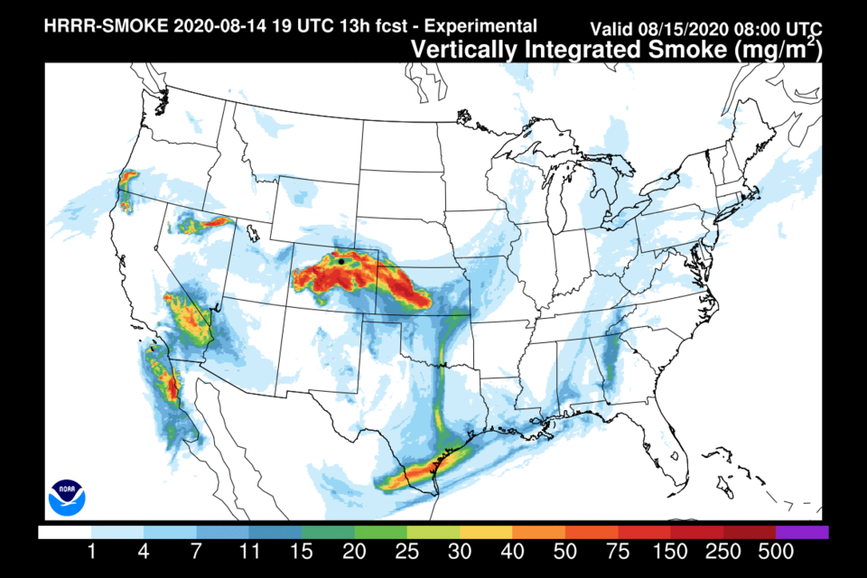
Smoke is a big deal in Colorado right now as a number of large fires are burning with minimal containment (Figure 1). Pulses of smoke will arrive every afternoon and remain into the evening as daytime heating and drying will allow fires to surge to more vigorous levels. The latest drought index map shows some relief has occurred in the southern counties, but the entire state is under some level of drought condition (Figure 2). The rainfall over the last week only occurred on the far eastern plains of Colorado (Figure 3).

Tropical moisture is still not making it into the northern and northeastern counties of the state (Figure 4) (note the tropical system Elida has dissipated).

We remain completely dry with highs near 100F through the weekend. It looks like the upper level high pressure system and ridge will remain stronger than thought earlier in the week (Figure 5).  Sorry! 

The Longer Range Forecast:

The precipitation expected over the next 5 days is really meager to none for the northwestern half of the state (Figure 6).

The change in the weather expected for Sunday now seems to occur by Tuesday.  The high center will have moved to northern Arizona by then (Figure 7) and will bring moisture up and around through the mountains (Figure 8). The GFS does give the state a small amount of water, overall, over the next 10 days (Figure 9).


About the Author: John Ensworth

John Ensworth used to work from Longmont as the PI for the NASA through the IGES (The Institute for Global Environmental Strategies). He now teaches technology, algebra, astronomy, meteorology, film school, and Lego robotics to middle/high school.
Read more


Comments


Current Weather

Cloudy

Cloudy

45°F

UV Index
0 Low
Pressure
29.81 Rising
Visibility
8 miles
Dewpoint
41 °F
Humidity
84%
Wind
S 2.9 mph
Gust
5.9 mph
Wind Chill
44 °F

Hourly Forecast

Today
11 PM
45°F
Cloudy
Tomorrow
12 AM
45°F
Cloudy
Tomorrow
1 AM
45°F
Showers
Tomorrow
2 AM
45°F
Cloudy
Tomorrow
3 AM
45°F
Cloudy
Tomorrow
4 AM
45°F
Cloudy
Tomorrow
5 AM
45°F
Cloudy
Tomorrow
6 AM
45°F
Cloudy
Tomorrow
7 AM
47°F
Cloudy
Tomorrow
8 AM
52°F
Cloudy
Tomorrow
9 AM
56°F
Cloudy
Tomorrow
10 AM
59°F
Intermittent clouds

7 Day Forecast

Partly sunny w/ t-storms

Wednesday

74 °F

Cooler with sunshine giving way to clouds, becoming windy this afternoon with heavy thunderstorms; gusty winds and small hail can accompany any downpour


Cloudy

Wednesday Night

45 °F

An evening shower in the area; otherwise, overcast


Intermittent clouds

Thursday

68 °F

Windy with intervals of clouds and sunshine


Mostly cloudy

Thursday Night

46 °F

Overcast in the evening, then partly cloudy late


Intermittent clouds

Friday

73 °F

Beautiful with times of clouds and sun


Mostly cloudy

Friday Night

44 °F

Mostly cloudy


Mostly cloudy

Saturday

75 °F

Mostly cloudy


Intermittent clouds

Saturday Night

45 °F

Clearing


Mostly cloudy w/ showers

Sunday

71 °F

Turning cloudy with a couple of showers in the afternoon


Mostly cloudy

Sunday Night

44 °F

A thunderstorm in parts of the area in the evening; otherwise, mostly cloudy


Sunrise and Sunset

Sunrise
5:46 AM
Sunset
8:08 PM

Based on AccuWeather data