In Brief:
Very high, near record heat and copious amounts of smoke hold through mid-week then first moisture returns, then cooler air returns.
Forecast Discussion:
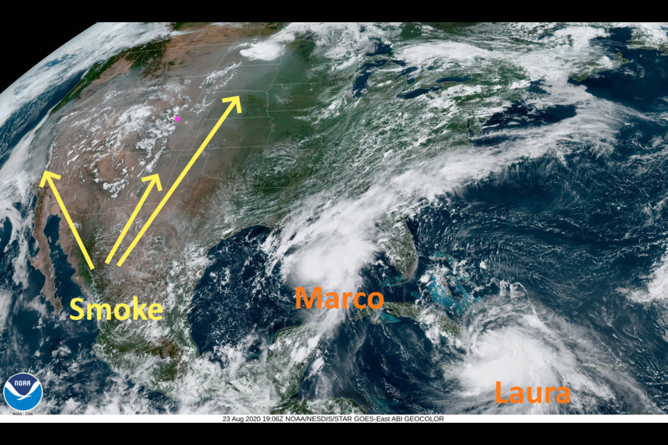
Looking at the visible satelite image from the GOES east satellite, you can see the smoke from the California and Colorado forest fires around a few patches of cumulus clouds in the west (Figure 1 in the gallery above). The tropical systems Marco and Laura are clear and bright in the Atlantic and Gulf of Mexico, lower right. Pulling the camera way out (Figure 2) you can see that a tendral of smoke is making its way across the Pacific all the way to Hawaii as smoke pours down into central Mexico and up into northern Canada.
What a rough summer this is turning out to be!
Zooming back in, you can see the smoke is still spiraling around the monster high pressure center in the West (Figure 3). The atmosphere will keep filling with smoke. That remarkable high is still sitting over the four corners Monday (Figure 4).
Temperatures are just shy of 100F most days through Thursday (notice the "end" of the heat keeps inching forward as the high shows little immediate sign of changing or moving away - Figure 5. The cool down was expected to come by Tuesday in the discussions last week.
Figure 6 shows moisture beginning to cycle around the high (from the dissipated Genevene) arriving here around Tuesday night and Wednesday. A chance of afternoon smoky thunderstorms returns Tuesday afternoon because of this.
Hopefully the higher humidities help with firefighting efforts.
The Longer Range Forecast:
Another source of (lower level) moisture might come from the remains of hurricane Marco as it dies drifting westward in Texas (Figure 7). Landfall for this storm seems to be pretty close to New Orleans Monday evening. Right on its heels will be the tropical system Laura, probably upgraded to a hurricane by that time as well, for a landfall near the Texas/New Orleans border (Figure 8).
Again, what a rough summer. (A similar double-storm hit occured in September of 1933).
Looking into the future for relief from the heat and smoke, the GFS gave us hope that changes were coming by around Septermber 1st in our previous discussions. Then the GFS backed off on that trough and had almost no cooling coming in. It has become bullish again about that trough with a really strong trough impacting the state around September 1st (Figure 9). A powerful cold front is now described by the model sweeping southward September 1st/2nd (the start of meterological Fall - Figure 10).
A good chance of rain, and high temperatures in the 70'sF are present in the weatherunderground model output as well (Figure 5).
Here's hoping this forecast holds!


