Skip to content
Join our Newsletter

Longmont Weather Forecast 8/26-27/2020

In Brief:

We have two more hot smoky days, with afternoon thunderstorms thrown in, before a cool down arrives just in time for September.

Forecast Discussion:

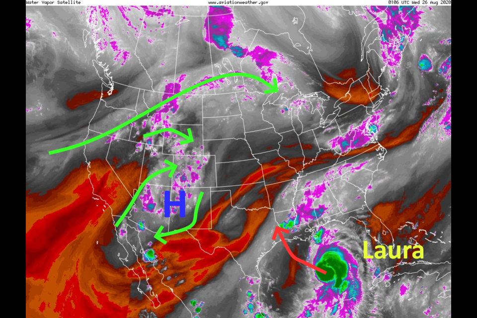
The High is moving south and is tapping a bit more tropical moisture. (Figure 1)

This is allowing afternoon storms to form once again. They are pretty widely scattered and you won't see them coming because of the smoke until the sky gets suddenly darker. For the short term, the ridge is still trying to hold on and cover the entire country (Figure 2).  It is now spreading smoke from the west coast, to the Great Lakes, and to the east coast (Figure 3).  Amazing.

Still, we might see a lucky 0.25 to 0.5 inch of rainfall over the next 5 days (Figure 4).   Temperatures stay in the 90'sF through Thursday before the High drifts south far enough that we get to cool to the 80'sF (Figure 5). 

The Longer Range Forecast:

With a cold front approaching we'll see compressional heating for a day on Sunday and "might" touch 90F one more time (Figure 5) in the medium range forecast window (10 days). The big change comes Monday with a sharp trough shoving the High into Mexico (Figure 6).  For a little bit, north winds should blow a lot of the smoke away and we'll see high temperatures in the upper 70'sF and lower 80'sF for a few days.  Yea!  Some meager rain chances are possible during this time period as well.

Meanwhile, hurricane Laura might reach Category 3 strength (or more??) before hitting the U.S. near the Texas and Louisiana Gulf Coast late Wednesday night.


About the Author: John Ensworth

John Ensworth used to work from Longmont as the PI for the NASA through the IGES (The Institute for Global Environmental Strategies). He now teaches technology, algebra, astronomy, meteorology, film school, and Lego robotics to middle/high school.
Read more


Comments


Current Weather

Mostly cloudy

Mostly cloudy

66°F

UV Index
2 Low
Pressure
30.11 Rising
Visibility
6 miles
Dewpoint
60 °F
Humidity
82%
Wind
NNW 1.7 mph
Gust
3.9 mph
Wind Chill
66 °F

Hourly Forecast

Today
9 AM
67°F
Intermittent clouds
Today
10 AM
70°F
Intermittent clouds
Today
11 AM
73°F
Intermittent clouds
Today
12 PM
75°F
Intermittent clouds
Today
1 PM
75°F
Intermittent clouds
Today
2 PM
74°F
Intermittent clouds
Today
3 PM
74°F
Intermittent clouds
Today
4 PM
73°F
Intermittent clouds
Today
5 PM
71°F
Intermittent clouds
Today
6 PM
70°F
Intermittent clouds
Today
7 PM
68°F
Mostly cloudy w/ t-storms
Today
8 PM
67°F
Partly sunny

7 Day Forecast

Partly sunny w/ t-storms

Wednesday

75 °F

Times of clouds and sun with a thunderstorm this afternoon; thunderstorms can bring hail and damaging winds


Mostly clear

Wednesday Night

53 °F

Clear to partly cloudy


Partly sunny

Thursday

87 °F

Partly sunny and pleasant


Clear

Thursday Night

55 °F

Clear


Mostly sunny

Friday

92 °F

Sunny to partly cloudy


Clear

Friday Night

57 °F

Clear


Mostly sunny

Saturday

94 °F

Mostly sunny and very warm


Mostly clear

Saturday Night

59 °F

Mainly clear


Partly sunny

Sunday

82 °F

Partly sunny and not as warm; a stray afternoon thunderstorm


Intermittent clouds

Sunday Night

57 °F

Mainly clear in the evening; mostly cloudy late


Sunrise and Sunset

Sunrise
5:32 AM
Sunset
8:34 PM

Based on AccuWeather data