Skip to content
Join our Newsletter

Longmont Weather Forecast 8/4-6/2020

In Brief:

A couple days of normal temperatures and wandering severe thunder storms will be replaced by dry and hot weather again.

Forecast Discussion:

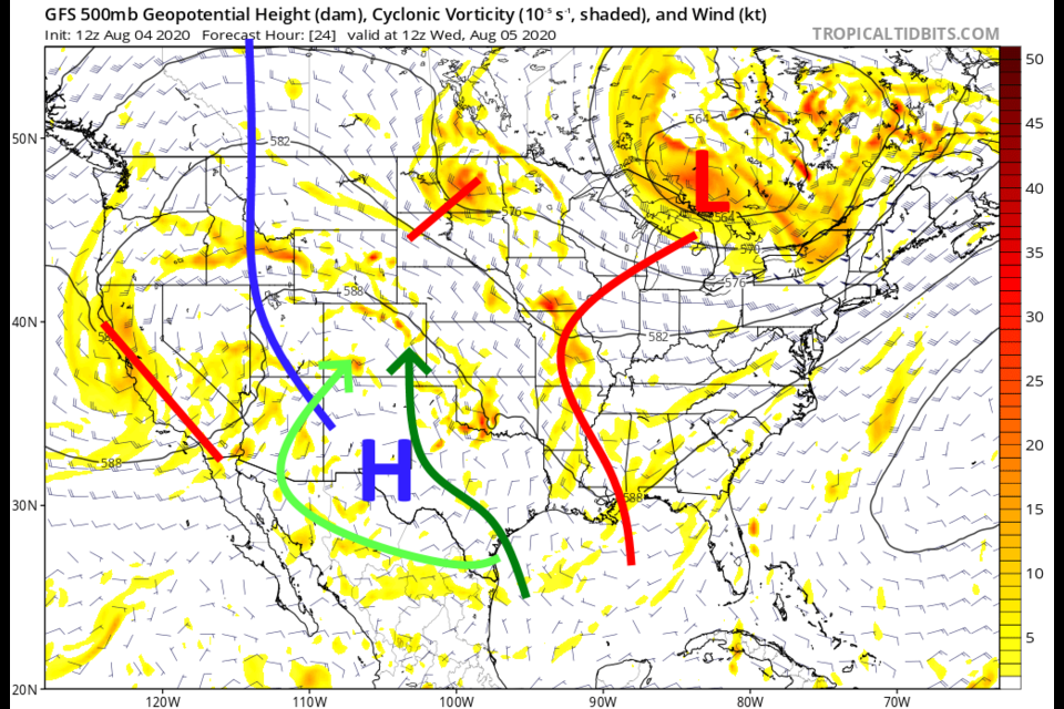
For a few more days, mid level moisture (light green arrow) and surface moisture (dark green arrows) won't have far to travel to get to Colorado (Figure 1 in the gallery above). Overall, there is less and less moisture to our west (Figure 2). Looking at Figure 1, we still have northwest flow aloft.  This adds up to Marginal and Slight risks of severe weather in the afternoons Tuesday and Wednesday.  The primary risk is for hail and damaging thunderstorm winds (Figure 3).  Rainfall through Wednesday morning will be confined to NE Colorado and the far SW corner of the state - and pretty light overall.  This model run has one big thunderstorm hit on the Palmer Divide (Figure 4).

We repeat the same weather setup on Wednesday (Figure 5) with severe weather chances, but not much more rain (Figure 6).

The Longer Range Forecast:

Oops, I forgot to annotate the 10 day graphical forecast, but you can see pretty plainly that we just go back to 90'sF for highs and very low rain chances Thursday then not much more beyond that (Figure 7). The reason we dry out is the western ridge getting stronger and the low level flow bending to the east allowing us to dry out (Figure 8). We are back to summer for a while.

I"m still taking my end-of-summer vacation with school on the way. I'll be on a 3 day schedule through the weekend (but things are looking pretty quiet after Wednesday!!).


The Video Forecast Discussion starting Wednesday 8/5


About the Author: John Ensworth

John Ensworth used to work from Longmont as the PI for the NASA through the IGES (The Institute for Global Environmental Strategies). He now teaches technology, algebra, astronomy, meteorology, film school, and Lego robotics to middle/high school.
Read more


Comments


Current Weather

Mostly cloudy

Mostly cloudy

61°F

UV Index
0 Low
Pressure
30.14 Falling
Visibility
7 miles
Dewpoint
55 °F
Humidity
82%
Wind
NNW 1.7 mph
Gust
4.5 mph
Wind Chill
61 °F

Hourly Forecast

Today
4 AM
57°F
Cloudy
Today
5 AM
56°F
Cloudy
Today
6 AM
57°F
Cloudy
Today
7 AM
59°F
Cloudy
Today
8 AM
62°F
Intermittent clouds
Today
9 AM
64°F
Intermittent clouds
Today
10 AM
67°F
Intermittent clouds
Today
11 AM
71°F
Intermittent clouds
Today
12 PM
74°F
Intermittent clouds
Today
1 PM
76°F
Intermittent clouds
Today
2 PM
76°F
Intermittent clouds
Today
3 PM
75°F
Intermittent clouds

7 Day Forecast

Thunderstorms

Monday

71 °F

Considerable clouds with a thunderstorm in spots in the afternoon


Mostly cloudy w/ t-storms

Monday Night

56 °F

Partly to mostly cloudy; a thunderstorm in spots in the evening followed by a brief shower or two late


Partly sunny w/ t-storms

Tuesday

76 °F

Periods of sun; a couple of thunderstorms around, some severe this afternoon; storms can bring flash flooding, hail, damaging winds, and even a tornado


Partly cloudy w/ t-storms

Tuesday Night

59 °F

A couple of evening thunderstorms around, some severe; partly cloudy; storms can bring flash flooding, hail, damaging winds, and even a tornado


Partly sunny w/ t-storms

Wednesday

77 °F

Intervals of clouds and sunshine with a thunderstorm in the afternoon


Partly cloudy w/ t-storms

Wednesday Night

55 °F

An evening thunderstorm in a couple of spots; otherwise, clear to partly cloudy


Partly sunny

Thursday

89 °F

Partly sunny, pleasant and warmer


Clear

Thursday Night

55 °F

Clear


Mostly sunny

Friday

94 °F

Mostly sunny and very warm


Mostly clear

Friday Night

55 °F

Mainly clear


Sunrise and Sunset

Sunrise
5:32 AM
Sunset
8:34 PM

Based on AccuWeather data