Skip to content
Join our Newsletter

Sunday Update: Longmont Weather Forecast: Cool and dry then warm again, Monday rain?

In Brief:

Very Cool start of week, small rain chances, then seasonable early fall sets in.

Sunday Update:

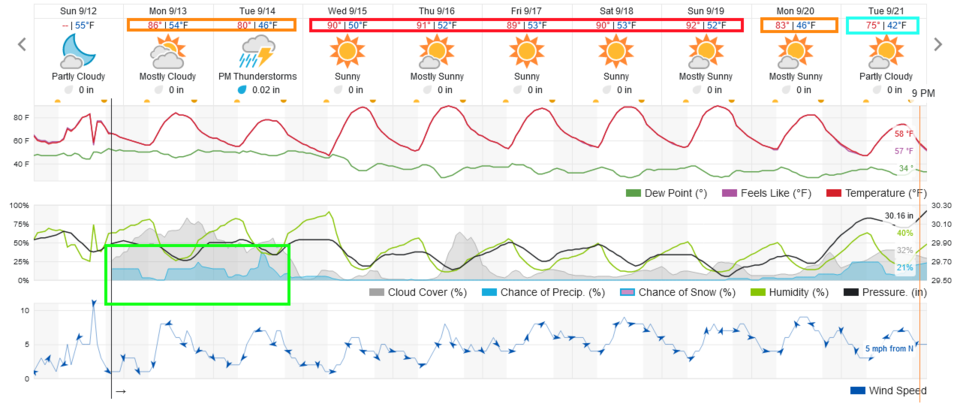
Just a quick note - a good flow of cool air is moving in.  Monday and Tuesday will be very comfortable/cool for the beginning of Fall (Tuesday afternoon). There are only 20-30% rain chances before we get dry again and see more seasonable tempeartuers (lower 80's) become our weather story. Enjoy!

End Sunday update.

Thursday Update:

A cold front swept down the Front Range Thursday PM.  Temperatures will be remarkably cooler for a day Friday.  The ridge brings back the heat for the weekend then a stronger cold front arrives.  There will be snow in Wyoming, possibly in the northern Colorado Rockies Monday into Tuesday (Figure 1 update). There are small rain chances at that time.  Then seasonal temperatures and dry weather return.

Figure1u_09162021
Figure 1 update: the 10 day graphical forecast from weatherunderground.com for Longomont

End Thursday update.

Forecast Discussion:

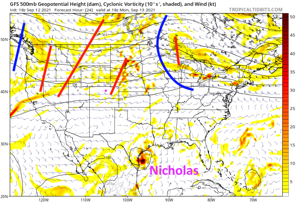
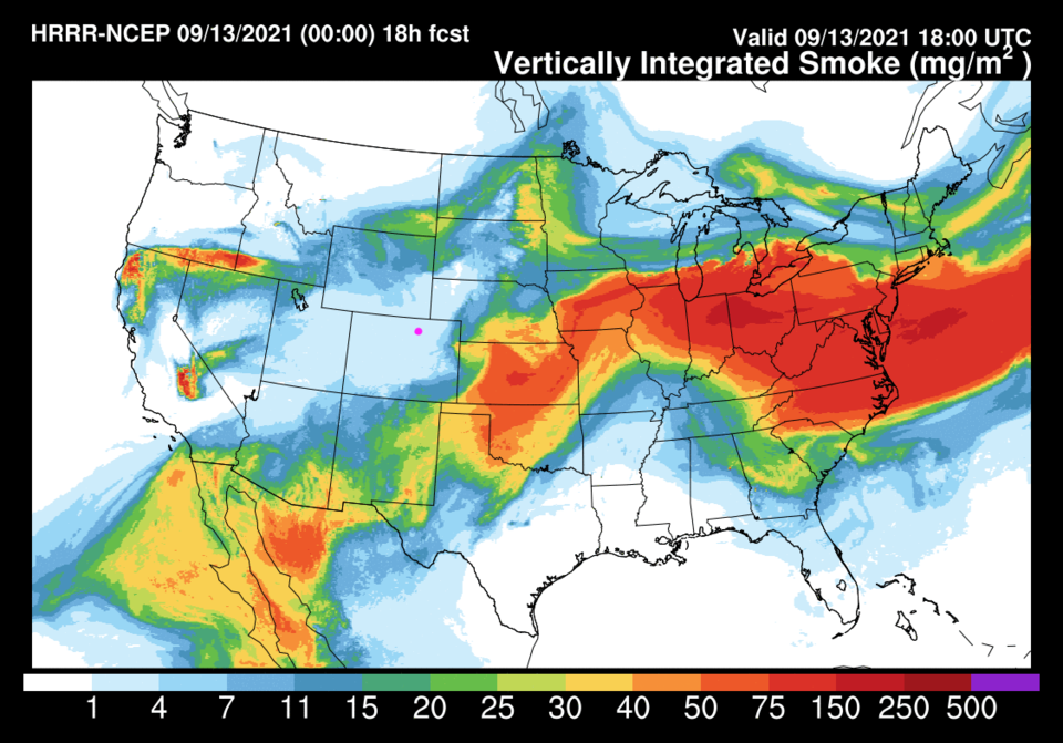
We start the week, this time, with a fair chance of thunderstorms through Tuesday (Figure 1). Temperatures will be close to normal for this time of year as another cold front sweeps down the state around 3 p.m. Monday. This unsettled and cooler weather is caused by a broad general trough that has set up temporarily over the western U.S. (Figure 2).  Smaller short waves (shorter red lines) are rippling through to kick off storms at times.  This airflow is diverting much of the western fires' smoke around our state for now - hurray!  (Figure 3).

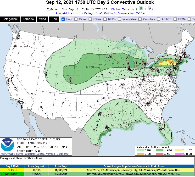
The Storm Prediction Center has painted most of northeastern Colorado with a Marginal Risk (1 on a scale of 1-5) for a threat for strong, damaging thunderstorm winds and large hail (Figure 4). Keep an eye on the western sky - especially in the afternoon.


Figure1_09122021
Figure 1: the 10 day graphical forecast from weatherunderground.com for Longmont, CO.
Figure2_09122021
Figure 2: the 500mb upper air forecast map for Monday noon from the GFS and tropicaltidbits.com
Figure3_09122021
Figure 3: the HRRR smoke at all levels forecast map for Monday afternoon from NOAA.
Figure4_09122021
Figure 4: the risk of severe weather from the Storm Prediction Center, Norman OK for Day 2, Monday.

The Longer-Range Forecast:

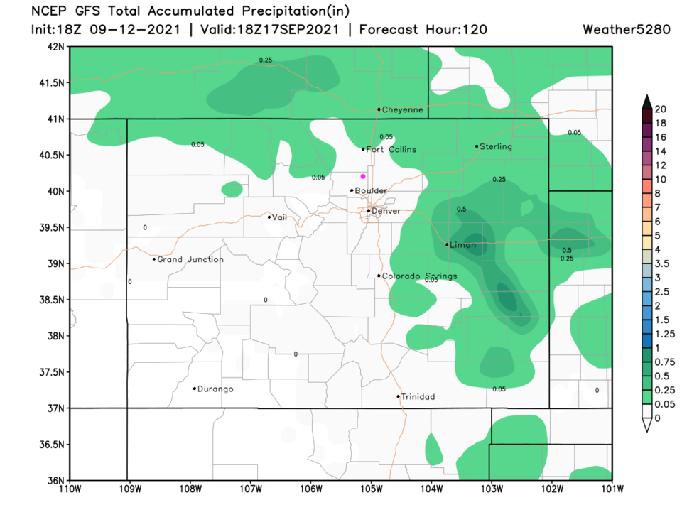
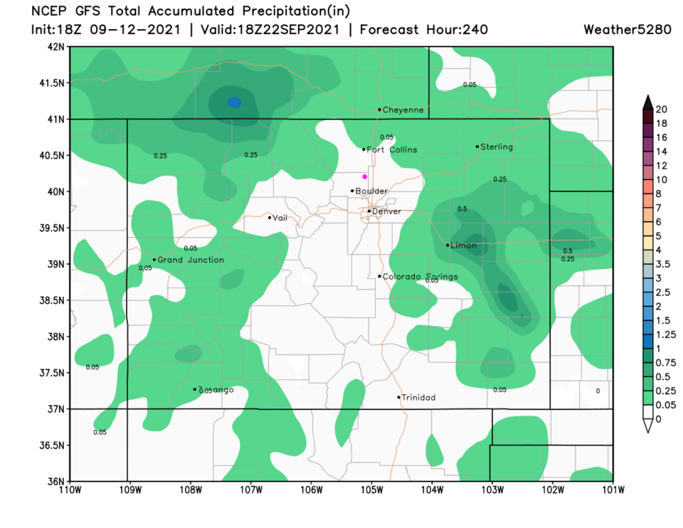
The storms that do form may give a few neighborhoods or towns significant water, but most folks in Colorado will pick up very little rain over the next five days (Figure 5) and even over the next 10 days (Figure 6).

Tropical Update:

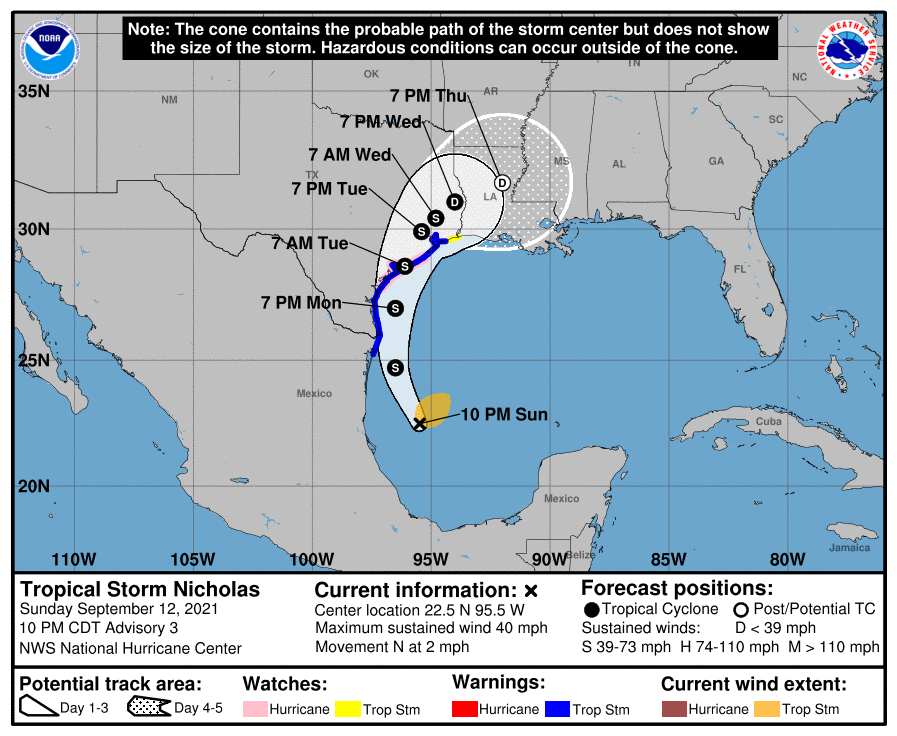
We do have an interesting tropical storm, Nicholas, that formed in the western Gulf of Mexico. Nicholas will graze the Texas coast and come ashore not far from Houston, Tuesday (Figure 7).


Figure5_09122021
Figure 5: the 5 day precipitation total from the GFS and weather5280.com
Figure6_09122021
Figure 6: the 10 day precipitation total from the GFS and weather5280.com
Figure7_09122021
Figure 7: the 5 day forecast for Nicholas from the National Hurricane Center.


About the Author: John Ensworth

John Ensworth used to work from Longmont as the PI for the NASA through the IGES (The Institute for Global Environmental Strategies). He now teaches technology, algebra, astronomy, meteorology, film school, and Lego robotics to middle/high school.
Read more


Comments


Current Weather

Light rain

Light rain

67°F

UV Index
1 Low
Pressure
30.22 Falling
Visibility
8 miles
Dewpoint
48 °F
Humidity
50%
Wind
ENE 2.9 mph
Gust
6.2 mph
Wind Chill
67 °F

Hourly Forecast

Today
4 PM
71°F
Thunderstorms
Today
5 PM
68°F
Thunderstorms
Today
6 PM
65°F
Cloudy
Today
7 PM
64°F
Cloudy
Today
8 PM
61°F
Intermittent clouds
Today
9 PM
58°F
Partly cloudy
Today
10 PM
55°F
Partly cloudy
Today
11 PM
53°F
Mostly clear
Tomorrow
12 AM
53°F
Mostly clear
Tomorrow
1 AM
52°F
Partly cloudy
Tomorrow
2 AM
52°F
Mostly clear
Tomorrow
3 AM
51°F
Mostly clear

7 Day Forecast

Mostly cloudy w/ t-storms

Wednesday

72 °F

Turning cloudy with a couple of thundershowers this afternoon


Partly cloudy

Wednesday Night

48 °F

Clearing


Mostly sunny

Thursday

77 °F

Mostly sunny and pleasant


Clear

Thursday Night

45 °F

Clear


Sunny

Friday

84 °F

Plenty of sunshine


Mostly cloudy

Friday Night

50 °F

Increasing clouds


Partly sunny

Saturday

83 °F

Partly sunny


Mostly clear

Saturday Night

53 °F

Clear to partly cloudy


Partly sunny

Sunday

86 °F

Partial sunshine


Mostly clear

Sunday Night

50 °F

Mainly clear


Sunrise and Sunset

Sunrise
6:43 AM
Sunset
7:06 PM

Based on AccuWeather data