The Video Forecast for this Week
In Brief:
A wet cold/chilly week with more snow stretches before us.
Thursday Update:
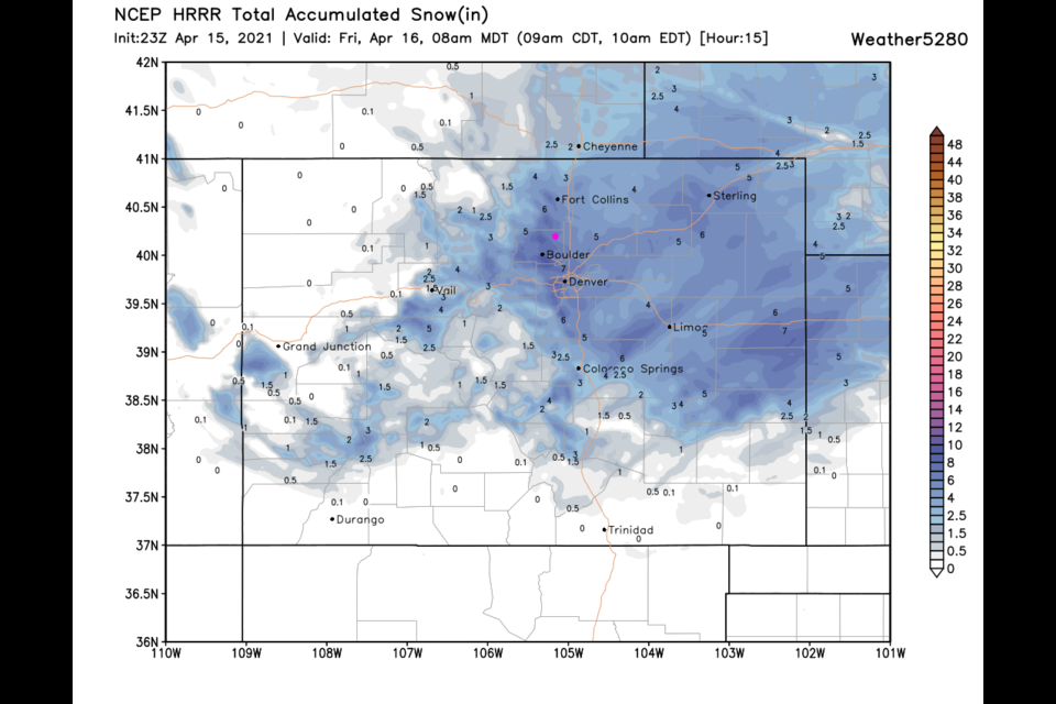
Snow is falling as I type. There is about 1 inch on grassy surfaces and slush beginning to form on the roadways. The HRRR (Figure 5 update) shows another 4-5 inches of snow by 10am Friday. (Pretty impressive.) The weatherunderground model (not shown) also shows 4-5 inches of snow with snowfall chances tapering off after 9am. You will have to drive more slowly in the morning, but this is excellent moisture!
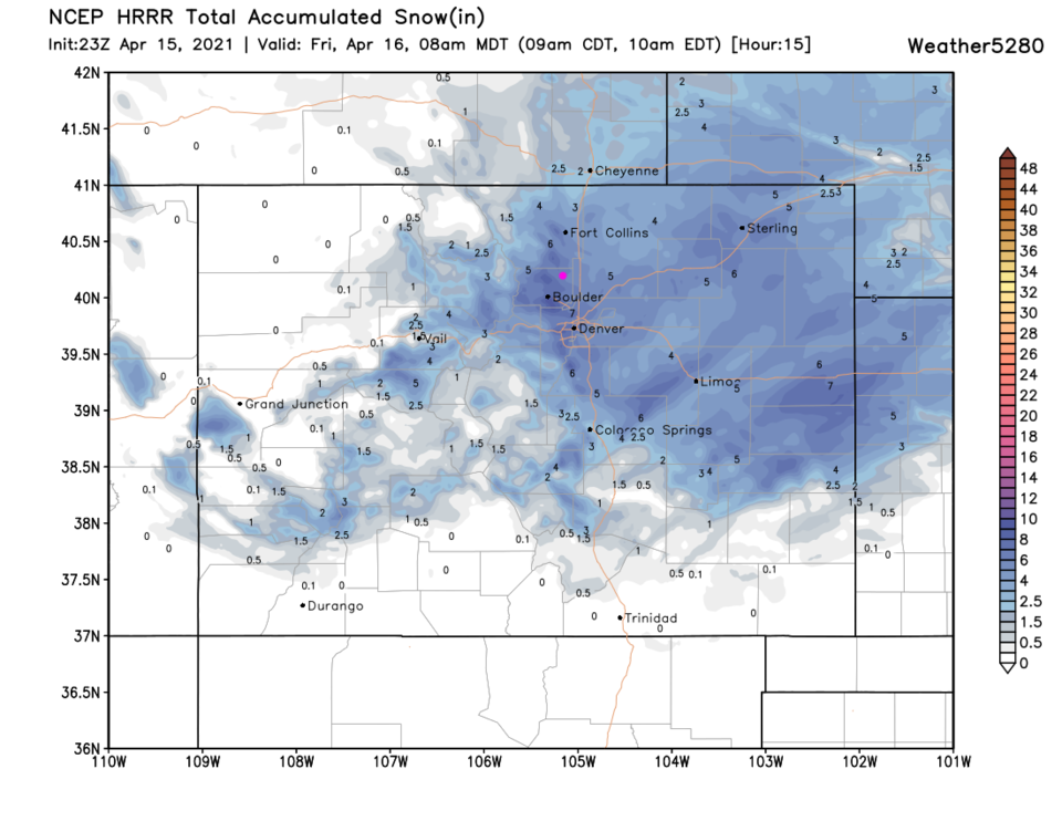 Figure 5 update: the HRR 10:1 snowfall forecast through 8am Friday.
End Thursday Update:
Wednesday Update:
The NWS said that it will be best, this week, to forecast just 24-36 hours out. Here we go! Figure 2 update shows the precipitation from our biggest hit of rain and snow moving in around 1-2pm Thursday (Figure 2 update). We start with rain, then transition to snow closer to sunset. The weatherundreground model gives us about 4-5 inches of snow by midday Friday. The GFS, through Friday PM, gives us about 0.75-1 inch of liquid total (Figure 3 update). We are in a bit of a down-slope/temperature hole along I-25 with the GFS giving us about 3-5 inches of snow, but heavier totals to the west and east (Figure 4 update). Your Thursday AM commute shouldn't be bad, but Friday AM could be pretty slow.
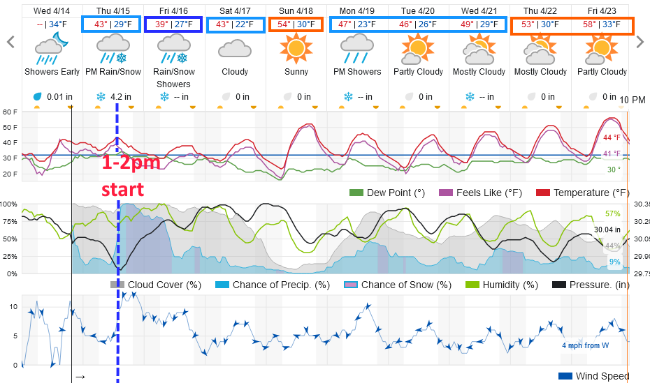 Figure 2 update: the 10 day graphical forecast from weatherunderground.com for Longmont, CO.
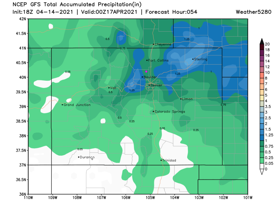 Figure 3 update: the 3 day precipitation total from the GFS and weather5280.com
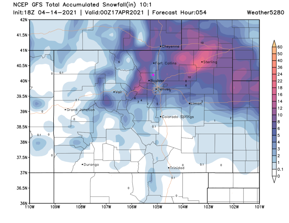 Figure 4 update: the 3 day (10:1 ratio) total snowfall forecast from the GFS and weather5280.com
End Wednesday Update:
Monday Update:
Quick update, the current model trends have the low jogging a bit further south. There are indications of more snow and less rain over this long, cold, wet week. The weatherunderground model gives us about 11 inches (Figure 1 update). The GFS (not shown) gives us 7-10 inches through Saturday. Wow. Stay tuned. This can still change!
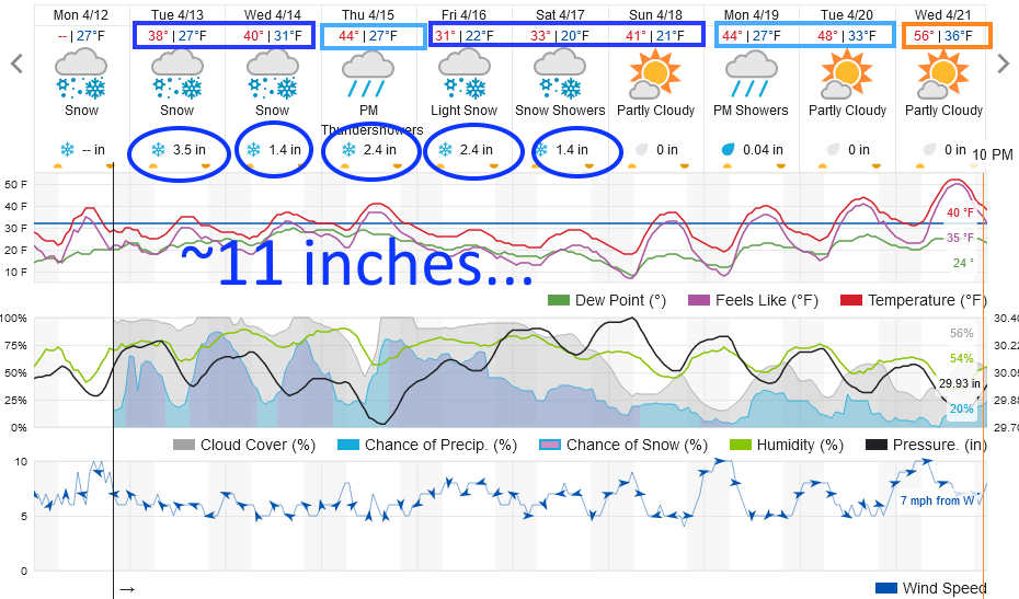 Figure 1 update: the 10 day graphical forecast from weatherunderground.com for Longmont, CO.
End Monday update.
Forecast Discussion:
Departing high pressure is gifting us a beautiful weekend, not in the 80s like last week, but still very nice.
A series of dry cool fronts or pushes of cool air will bring about a change starting Sunday. By Sunday afternoon, the first pretty strong cold front will be clear of the state to the south. Winds will pick up but no precipitation is expected with these changes initially (Figure 1).
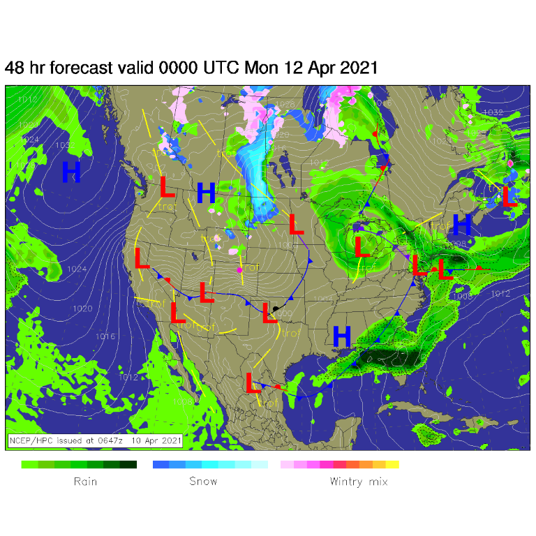 Figure 1: the surface forecast analysis for Sunday PM from NCEP.
The Longer Range Forecast:
For most of the week — like Thursday in Figure 2 — a giant trough and cut-off low will dominate the West. This pattern will not depart until maybe next weekend. You can see temperatures cool down into the 50s on Monday and last all week (Figure 2). We had significant snow in an earlier forecast — when highs were expected in the 30s — now it is expected to fall as rain, at least in the day.
If this low sets up to our northwest, we will be on the warm side of the system and most of the precipitation will fall in the form of rain. If this low forms further south, then we'll see more low land snows (Figure 3). What is clear, the rain/snow chances hang in for a long time.
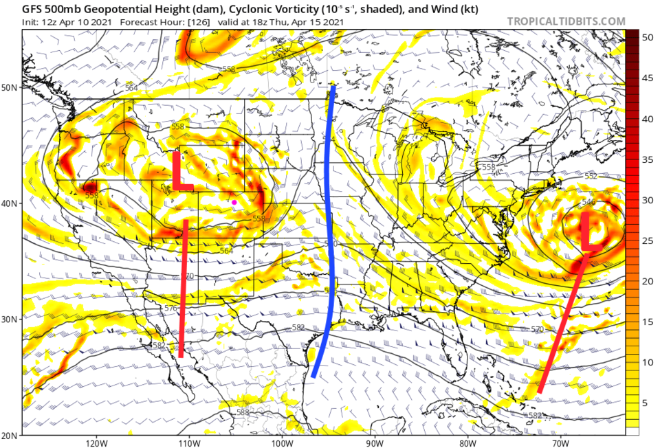 Figure 2: the 500mb upper air forecast map for Thursday noon from the GFS and tropicaltidbits.com
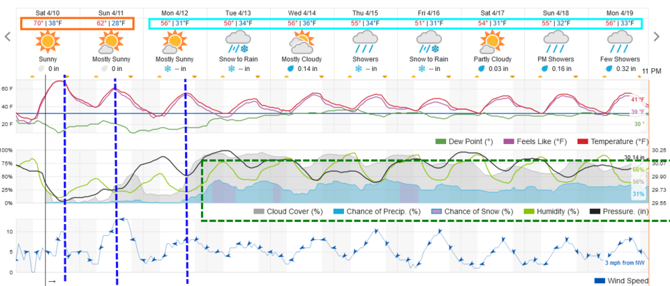 Figure 3: the 10 day graphical forecast from weatherunderground.com for Longmont, CO.
As for precipitation, with warmer temperatures currently expected, the low lands should only see snow at night. We may see 2-5 inches at present, but daytime rains would melt it. (Figure 4). The weather service says that we should see 1/2-1 inch of total precipitation through this next week. The GFS (Figure 5) gives us 1.25-1.5 inches of liquid. That would be great news for the drought!
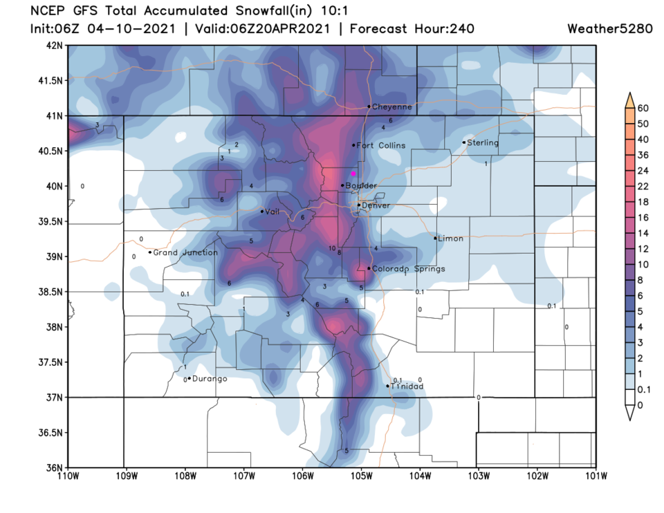 Figure 4: the GFS total snowfall forecast (10:1 ratio) for the next 10 days from weather5280.com.
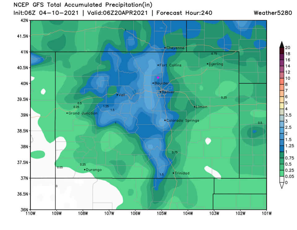 Figure 5: the GFS total precipitation for the next 10 days from weather5280.com.


