In Brief:
A warm morning changes to midday rain then late afternoon snow. If you are close to the foothills, significant snow should build up.Saturday Update:
We pulled into the driveway after our Spring Break road trop (first vacation in 1.5 years) a couple of hours ago. We arrived at our last hotel at 3am today. I need to make this an update again, followed by a full forecast in the morning. We did notice the cold air that was trapped along I-25 built up local pollution enough to lower visibilities and make an air quality alert needed for all the big cities. That was much more common a few decades ago! The next system will clear the air quickly.
Another very wet, but warmer, storm is hitting in bursts Sunday afternoon into Monday morning, then again Tuesday/Wednesday. Another system is slated for Friday/Saturday (Figure 2 update). We'll keep throwing water at our drought conditions this week. Yea!
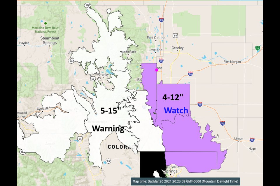
There is a winter storm watch for western Longmont and the foothills. Places on the Plains will see mainly rain but where it stays cold enough for snow, significant snow will build up again (mainly in the mountains where there is a winter storm warning Figure 3 update). Rain at noon should change to snow around 5-7pm. Here is the text from the NWS:
...WINTER STORM WATCH IN EFFECT FROM SUNDAY EVENING THROUGH MONDAY
AFTERNOON...
* WHAT...Heavy snow possible. Total snow accumulations of 4 to 12
inches possible, heaviest amounts over Douglas and Elbert counties.
* WHERE...Boulder and the western suburbs of Denver, Denver, and
Castle Rock.
* WHEN...From Sunday evening through Monday afternoon.
* IMPACTS...Travel could be very difficult. The hazardous conditions
could impact the Monday morning and evening commutes. Snow covered
roads will make travel hazardous.
PRECAUTIONARY/PREPAREDNESS ACTIONS...
Monitor the latest forecasts for updates on this situation.
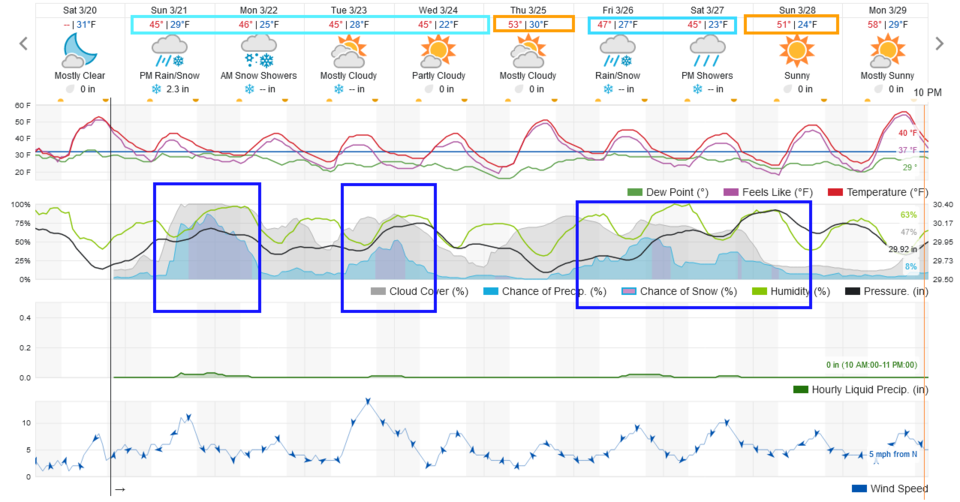 Figure 2 update: the 10 day graphical forecast for Longmont from weatherunderground.com
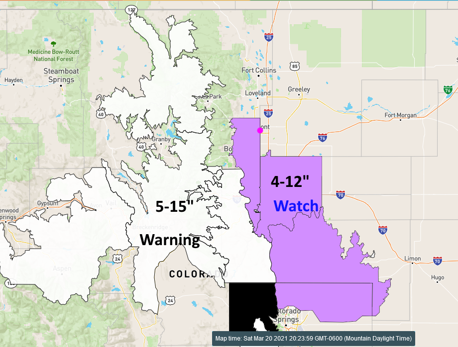 Figure 3 update: the current winter watches and warnings map from the NWS
End Saturday Update.
Friday Update:
Statewide unusual warmth is the rule through Sunday morning (Figure 1 update). You can see the cooling effect of the snow pack in NE Colorado in the map as well. Wow. Rain should return just afternoon Sunday changing to snow in the evening. Right now it looks like 1-3 inches is possible. Next week will be cool and damp.
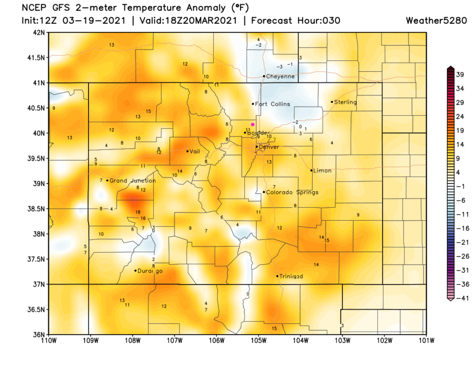 Figure 1 update: the surface temperature anomaly map for Saturday noon from weather5280.com
End Friday update.
Wednesday Update:
Very little snow ended up coming from the Tuesday/Wednesday passing storm (yea!). We did not get 1-3 inches as I thought below. Now the warm up begins with a very nice start of the weekend ahead. Our next storm, arriving Sunday/Monday, might come in with 3-5 inches of snow, but more on that later! Go soak your back in a nice hot bath.
End of the Wednesday update.
The Forecast Discussion:
This storm ended up like the GFS continued to predict all week. We actually went to "crazy town" (to quote myself).
DIA saw 27.1 inches making it the fourth largest storm in meteorological history at the airport ... even though it faked everyone out with a 24 hour delay.
Figure 1 shows my hand-drawn (poorly) analysis of the 20 and 30 inch regions in Boulder County. Longmont reported 20 inches in town and 15 inches to the west.
*Note the 40 inch report just south of the county (arrow).
Figure 2 is Larimer County with again 20 and 30 inch regions highlighted. Across Denver 15-25 inch totals were common. Melting and compaction of the snow yielded lower totals than official measurements would have.
Official snowfall measurements often use a board and multiple measurements during the storm.
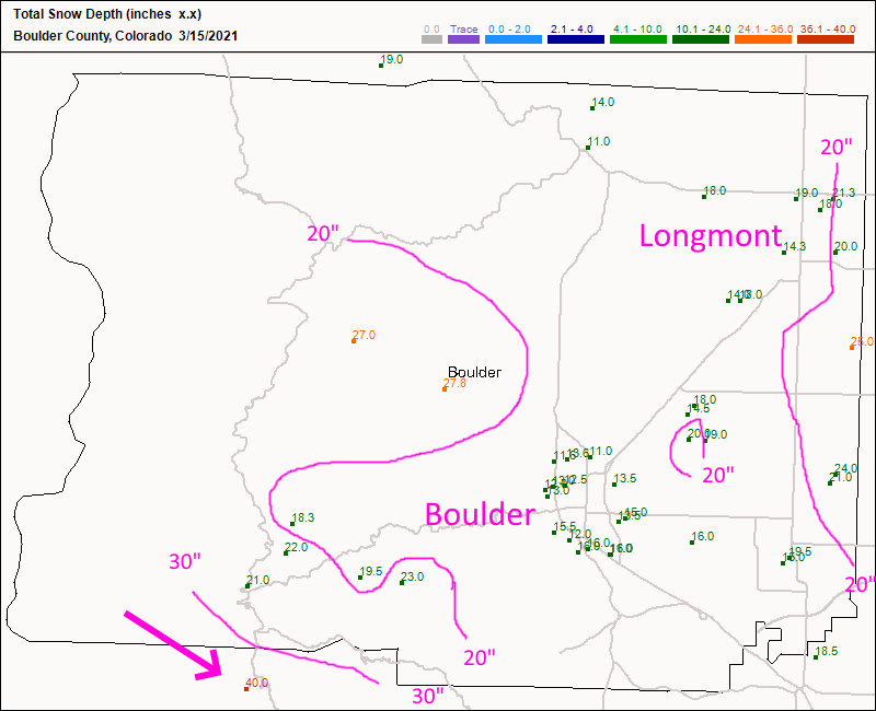 Figure 1: the snow depth total as of 7am Monday from CoCoRaHS for Boulder, Co.
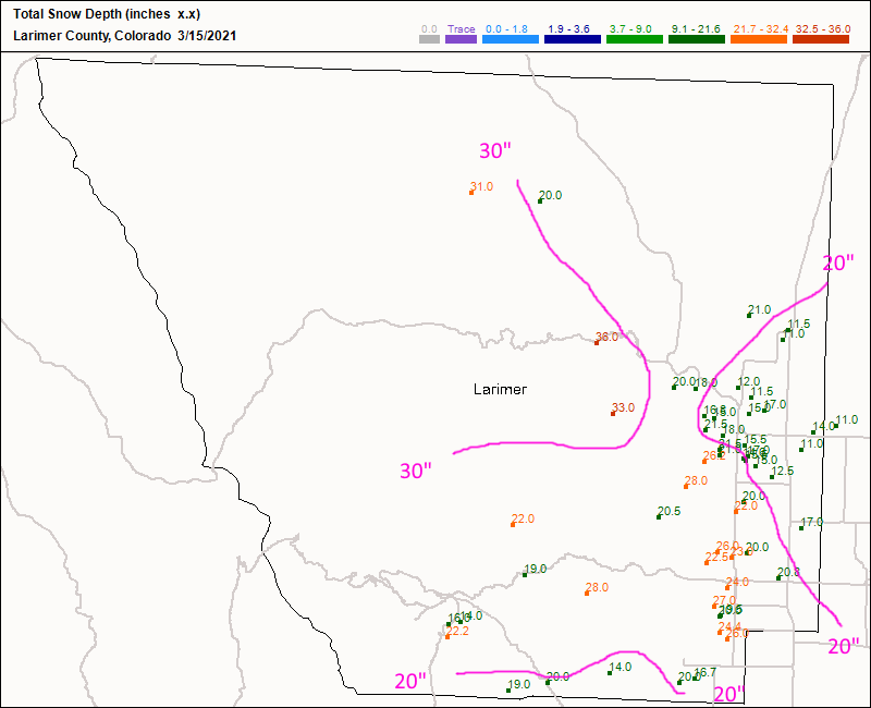 Figure 2: the snow depth total as of 7am Monday from CoCoRaHS for Larimer, Co.
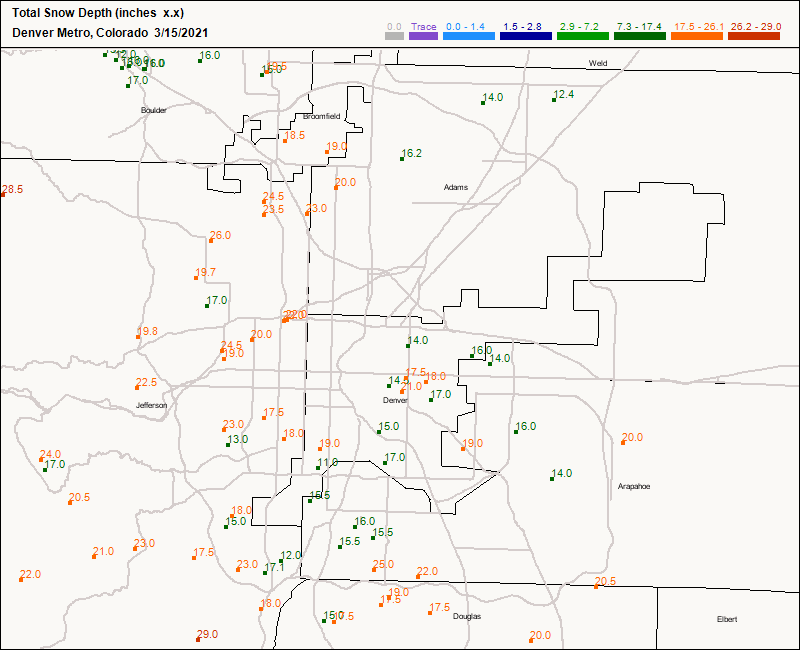 Figure 3: the snow depth total as of 7am Monday from CoCoRaHS for Denver metro.
 Another, much weaker, cutoff low will follow in this system's wake and lay down a bit more snow Tuesday afternoon into Wednesday morning. You can see the messy pattern in the future frontal analysis map - Figure 4. The snow should begin falling around 2 p.m. Tuesday to 10 a.m. Wednesday (Figure 5) and amount to a new 1-3 inches around Longmont (Figure 6).
In the meantime, watch out for very thick fog at times tonight into Tuesday morning — all this moisture and clear nighttime skies could reduce visibility to near zero at times.
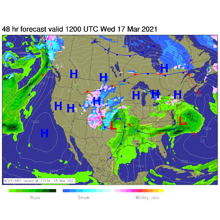 Figure 4: the surface analysis map for the U.S. Wednesday AM from NCEP
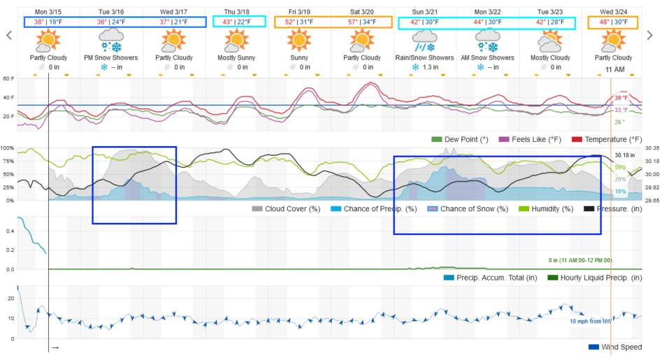 Figure 5: the 10 day graphical forecast for Longmont from weatherunderground.com
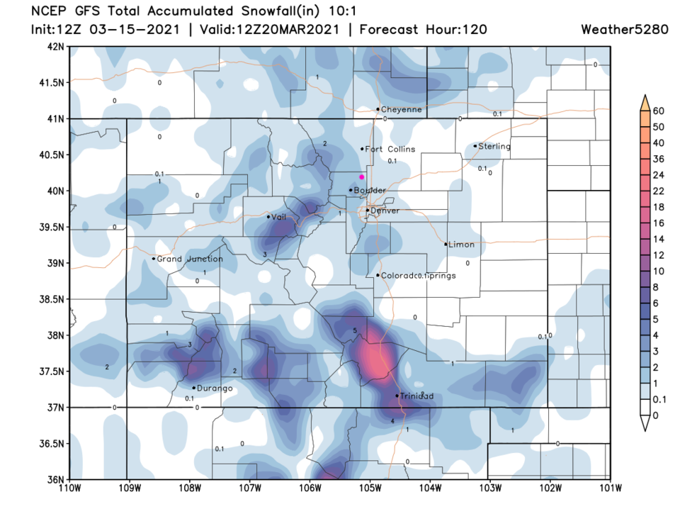 Figure 6: the 5 day snowfall total from the GFS and weather5280.com
The Longer Range Forecast:
Temperatures rebound to the 50s by the weekend (hurray!). There is another storm looming on the horizon for the start of next week, but that is a story for a future post!


