In Brief:
Another mild week is ahead with the exception of a minor Monday/Tuesday storm and unsettled weather next weekend.
Wednesday Night Update:
Very little change to the forecast.. we will be warm (for this time of year) and dry until a Saturday afternoon cold front arrives. Temperatures drop about 10 degrees (still within normal ranges) and we have a tiny chance of snow for about 3 days (Figure 2 update). The end of next week will be warm and dry again.
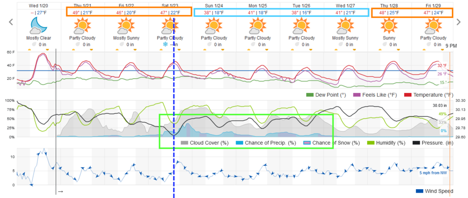 Figure 2 update: the 10 day graphical forecast from weatherunderground.com for Longmont, CO.
End Wednesday Night Update.
Sunday Night Update:
While the mountains will see snow Monday/Tuesday, most locations along I-25 will see a coating of snow with a just a few lucky locations getting 1-2 inches (Figure 1 update). It will be chilly for Monday/Tuesday then rapidly warm up on Wednesday. Get that somewhat bigger coat out!
 Figure 1 update: a snippet of the 10 day graphical forecast for Longmont from weatherunderground.com
End Sunday Night Update.
Forecast Discussion:
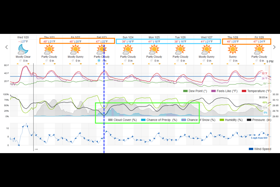
We'll start this discussion with the big picture graphical forecast (Figure 1). The orange boxes around temperatures are the days we are at the top of our normal range of temperatures. The light blue boxes are at the low range or a bit below normal. There is a minor chance of showers Monday into early Tuesday then unsettled weather seems to settle in Friday into next week.
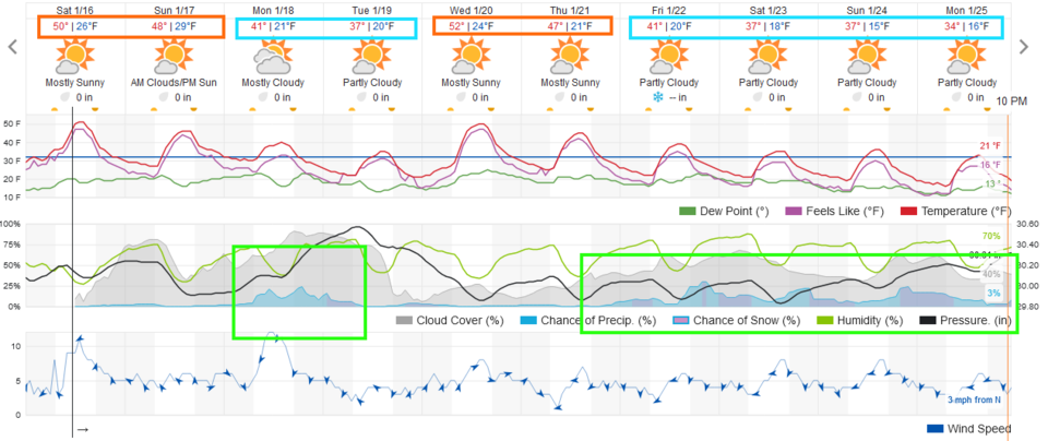 Figure 1: the 10 day graphical forecast from weather5280.com for Longmont, CO.
We can watch these systems play out in the 500mb maps. The Monday 500mb map (Figure 2) has a departing minor ridge over the state with a couple of troughs lining up on the west coast. The next day, they have consolidated and low pressure system has intensified out west. We are on the 'stormy' side of the trough (but fairly far away from the moisture and upward motion associated with the trough (Figure 3)).
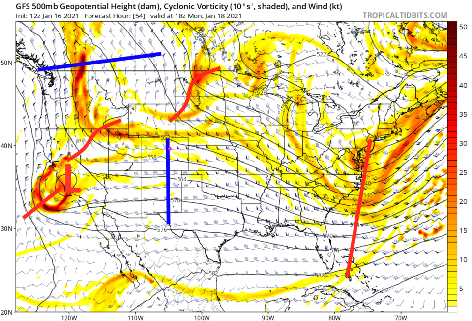 Figure 2: the 500mb upper air forecast map for Monday noon from the GFS and tropicaltidbits.com
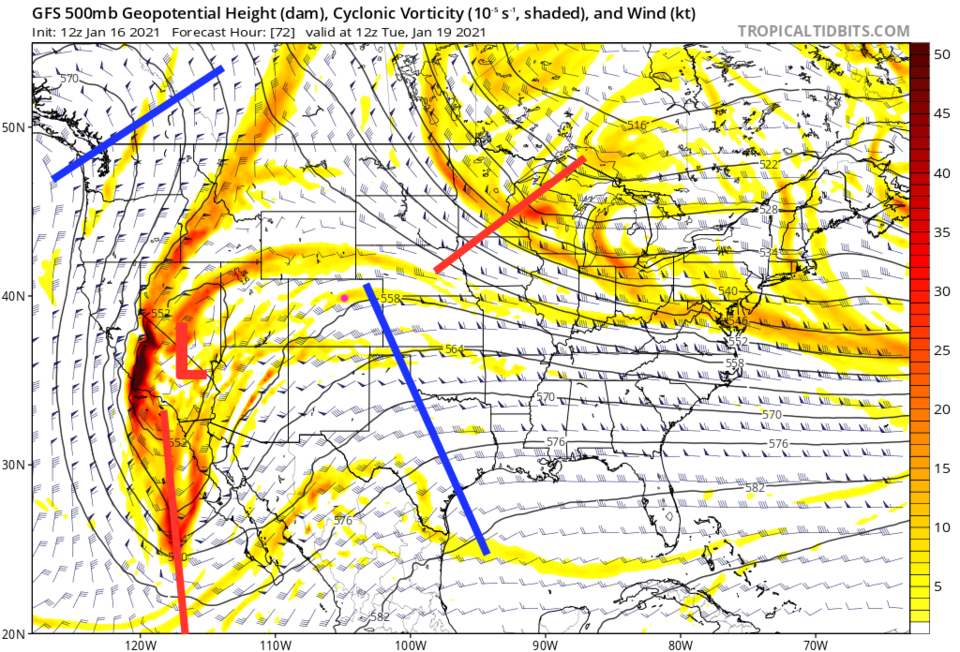 Figure 3: the 500mb upper air forecast map for Tuesday AM from the GFS and tropicaltidbits.com
The snow from this first system is fairly good for the mountains (Figure 4). The southwestern Colorado mountains are the big snow winners. We might see a coating to an inch down along Interstate 25.
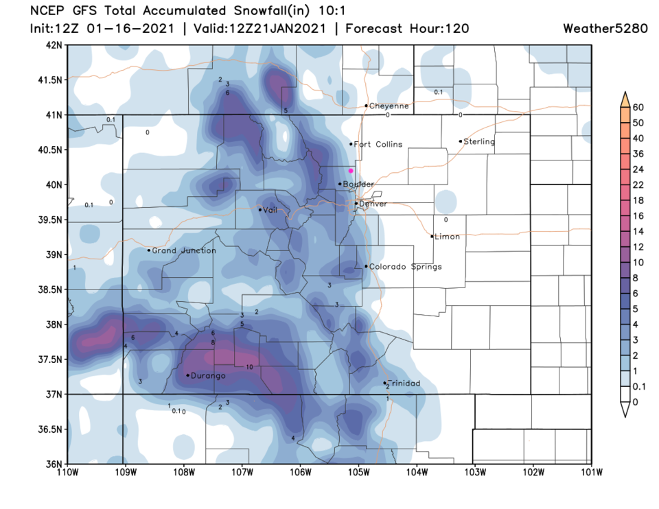 Figure 4: the 5 day (10:1 ratio) total snowfall forecast from the GFS and weather5280.com
The Longer Range Forecast:
Turning our attention to the end-of-week system, another deep trough replaces the one above (Figure 5). This will not move out quickly and we'll remain on the 'stormy' side of the trough for many days.
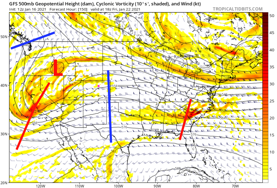 Figure 5: the 500mb upper air forecast map for Friday noon from the GFS and tropicaltidbits.com
We will have to check in on this later in the week, but a surface low to our southeast is expected to drift by slowly next weekend pumping significant snow into the state a week from now (Figure 6). A total (over 10 days) of almost 2 feet of snow may build up in mountain locations and about 6 inches may fall along Interstate 25 (Figure 7). That is a long way off, but could be a signal of a nice pattern change and more winter-like weather for a bit. Enjoy the current 'warm' dryness!
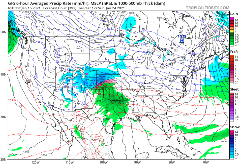 Figure 6: the 6 hour averaged precipitation around NEXT Sunday evening/sunset from the GFS and tropicaltidbits.com
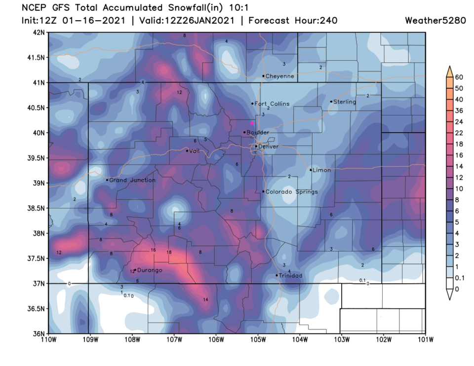 Figure 7: the 10 day (10:1 ratio) total snowfall forecast from the GFS and weather5280.com


