Skip to content
Join our Newsletter

Monday Update: Longmont Weather Forecast: Cool with showers every few days

The Video Forecast for this Week

In Brief:

A cold front will pass about every four days bringing mountain snows, lower level lower rain chances.

Monday update:

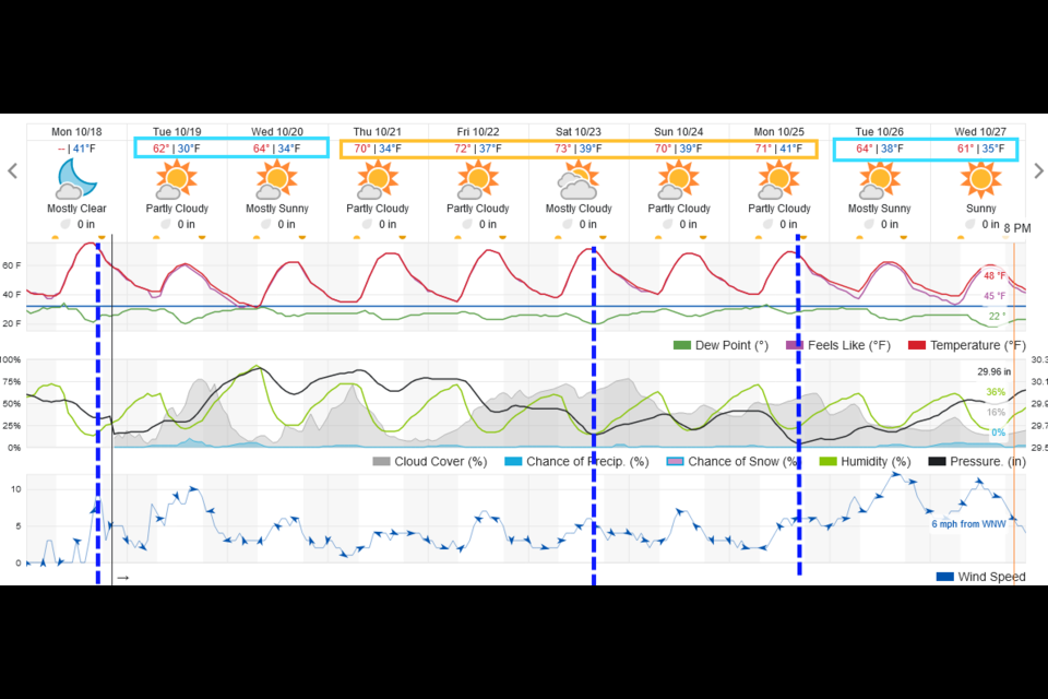
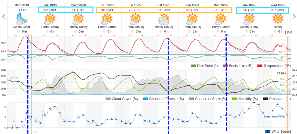
The moisture we were expecting is fading out of the forecast.  Figure 1 update shows at least three cool fronts coming in to the state over the next 10 days. We get chilled after a Monday PM front, then cool down a bit again Saturday afternoon and again Monday afternoon.  Sorry - quiet comfortable weather will continue.

Programming note, I will be taking my first vacation in about 2 years from Friday through Halloween.  Thanks all! IF a big blizzard arrives, I'll return for updates.

Figure1u_10182021
Figure 1 update: the 10 day graphical forecast for Longmont from weatherunderground.com

End Monday update.

Forecast Discussion:

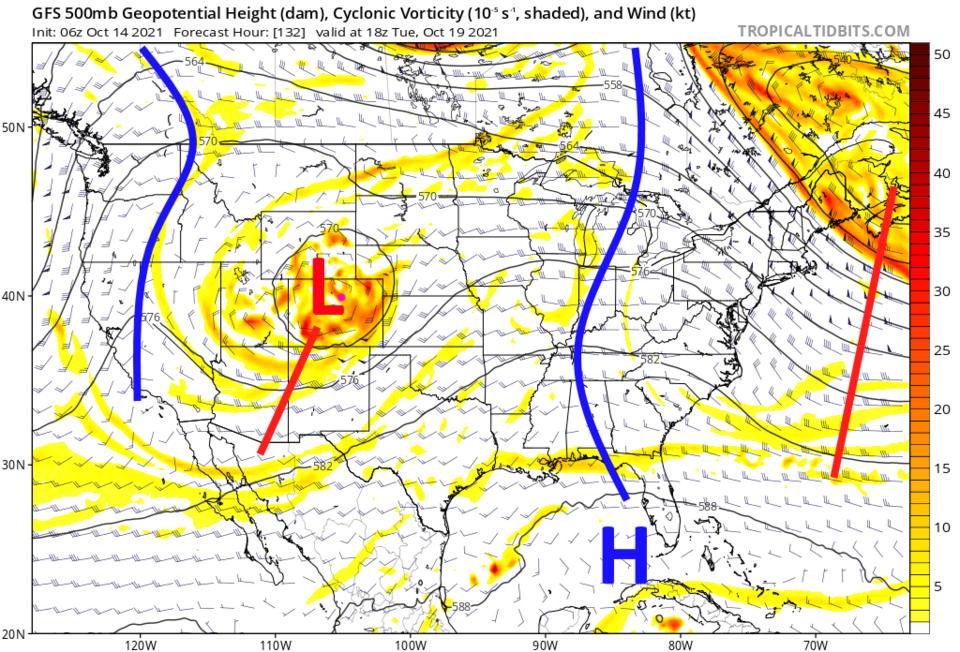
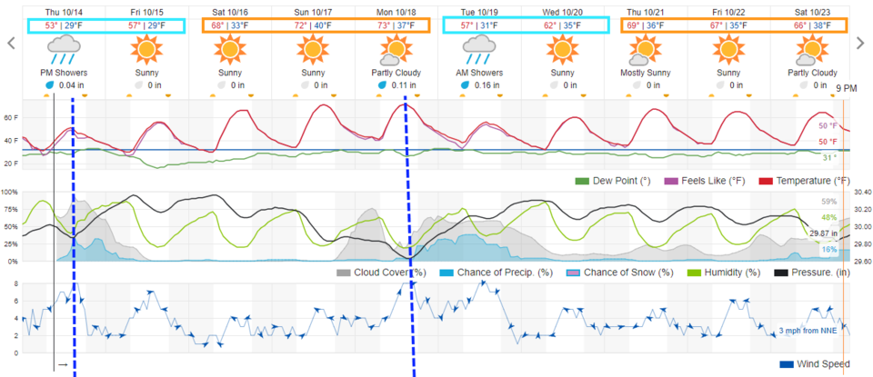
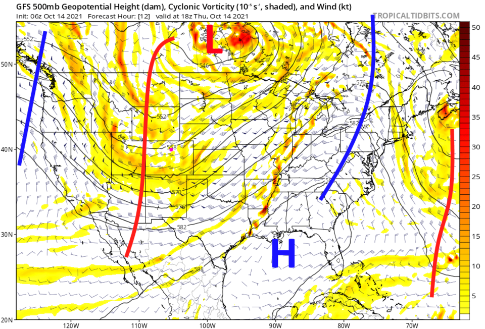
Looking out 10 days (Figure 1) it looks like our next three cold fronts will arrive about four days apart (Thursday, Monday, and maybe the following Saturday). The storm at the start of this forecast window, powered by a cold trough passing overhead (Figure 2) may be able to provide a dusting of snow along I-25 at the end of the period of showers Thursday night.

Figure1_10142021
Figure 1: the 10 day graphical forecast for Longmont from weatherunderground.com
Figure2_10142021
Figure 2: the 500mb forecast map for Thursday noon from tropical tidbits.


The Longer-Range Forecast:

After that trough passes, a quickly moving ridge will warm us up and deliver a very comfortable and dry weekend (Figure 1).  A trough will break off under that ridge creating a cut-off low that will bring our next chance of rain and mountain snows Tuesday (Figure 3). 

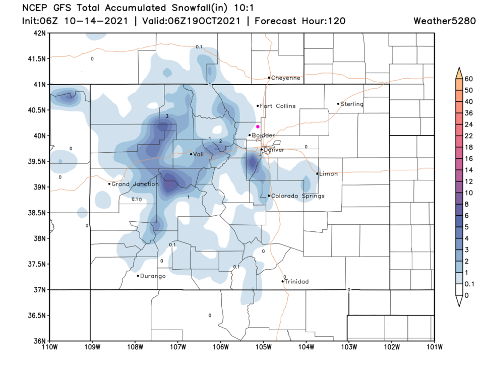
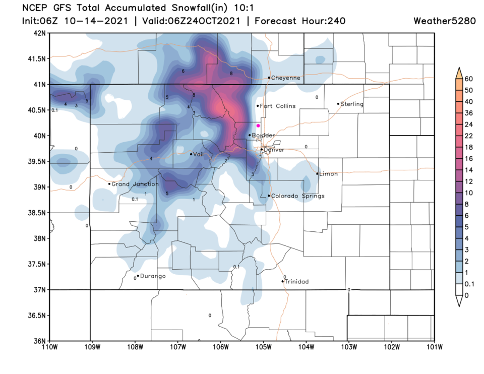
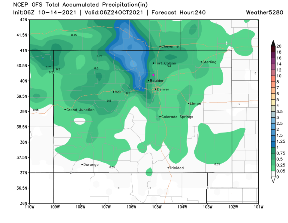
The first storm will drop a small amount of measurable snow in the mountains, the Palmer Divide and spots on the Plains near Limon (Figure 4). Adding the storm early next week to that map, and the mountains get a better hit of snow (Figure 5). Over the next 10 days, northern and central Colorado will get the best water totals (Figure 6).

Note: I will be on vacation the last week of October and do not plan to post updates unless an epic storm materializes.


Figure3_10142021
Figure 3: the 500mb forecast map for Tuesday noon from tropical tidbits.
Figure4_10142021
Figure 4: The 5 day snowfall total (10:1 ratio) from weather5280.com
Figure5_10142021
Figure 5: The 10 day snowfall total (10:1 ratio) from weather5280.com
Figure6_10142021
Figure 6: The 10 day rainfall total from weather5280.com


About the Author: John Ensworth

John Ensworth used to work from Longmont as the PI for the NASA through the IGES (The Institute for Global Environmental Strategies). He now teaches technology, algebra, astronomy, meteorology, film school, and Lego robotics to middle/high school.
Read more


Comments


Current Weather

Cloudy

Cloudy

61°F

UV Index
0 Low
Pressure
30.09 Steady
Visibility
6 miles
Dewpoint
48 °F
Humidity
63%
Wind
NW 1.7 mph
Gust
3.6 mph
Wind Chill
61 °F

Hourly Forecast

Today
2 AM
60°F
Intermittent clouds
Today
3 AM
59°F
Intermittent clouds
Today
4 AM
58°F
Intermittent clouds
Today
5 AM
57°F
Intermittent clouds
Today
6 AM
56°F
Intermittent clouds
Today
7 AM
58°F
Intermittent clouds
Today
8 AM
61°F
Intermittent clouds
Today
9 AM
66°F
Intermittent clouds
Today
10 AM
70°F
Intermittent clouds
Today
11 AM
74°F
Mostly cloudy
Today
12 PM
77°F
Cloudy
Today
1 PM
78°F
Cloudy

7 Day Forecast

Thunderstorms

Friday

80 °F

Mostly cloudy and not as warm; a thunderstorm in parts of the area in the afternoon


Mostly cloudy

Friday Night

56 °F

Cloudy in the evening; partly cloudy late


Thunderstorms

Saturday

78 °F

Mostly cloudy with a thunderstorm in spots this afternoon; thunderstorms can bring localized damaging wind gusts


Showers

Saturday Night

54 °F

Mostly cloudy with occasional rain and drizzle late


Partly sunny

Sunday

78 °F

A morning shower in spots; otherwise, partial sunshine


Clear

Sunday Night

49 °F

Clear


Partly sunny

Monday

84 °F

Partly sunny and warmer


Partly cloudy

Monday Night

51 °F

Partly cloudy


Intermittent clouds

Tuesday

76 °F

Times of clouds and sun


Partly cloudy w/ t-storms

Tuesday Night

48 °F

A couple of evening showers and a thunderstorm; otherwise, partly cloudy


Sunrise and Sunset

Sunrise
6:38 AM
Sunset
7:14 PM

Based on AccuWeather data