Skip to content
Join our Newsletter

Longmont Weather Forecast: Heat ends; cool and damp arrives

In Brief:

A front arriving Tuesday PM begins a period of cool, showery weather.

Tuesday update:

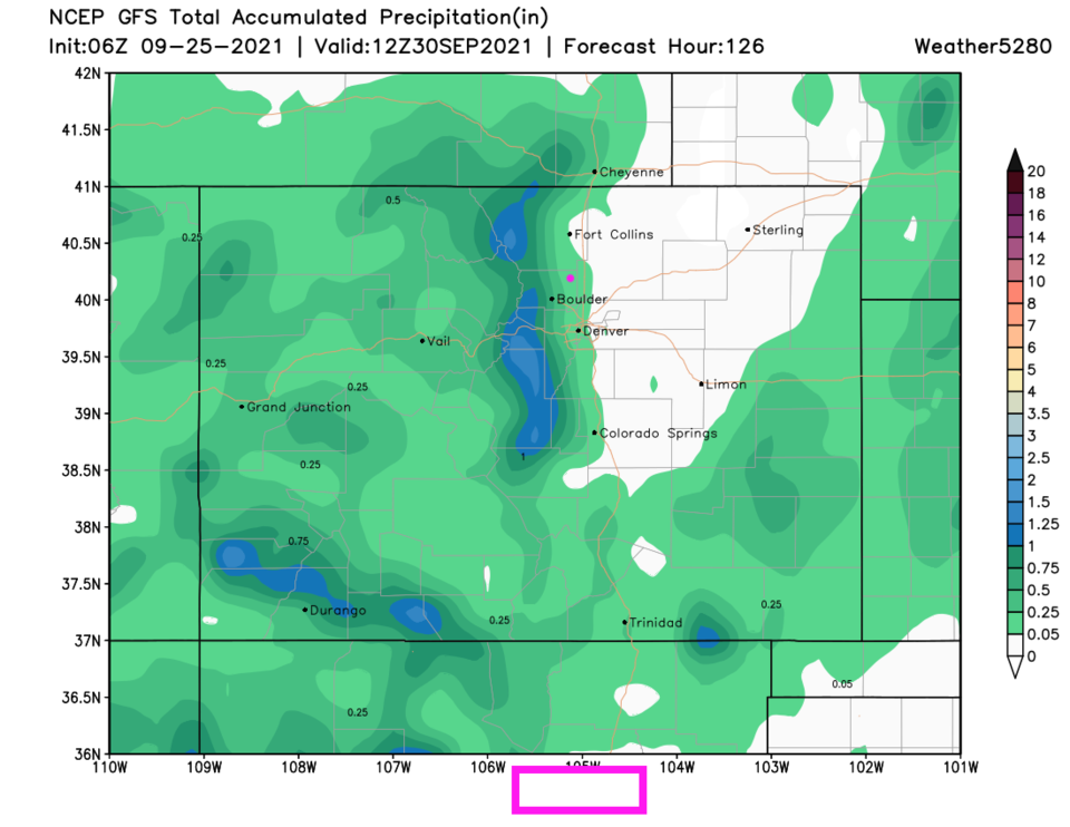
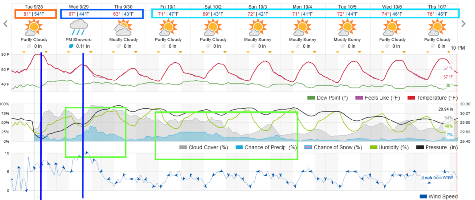
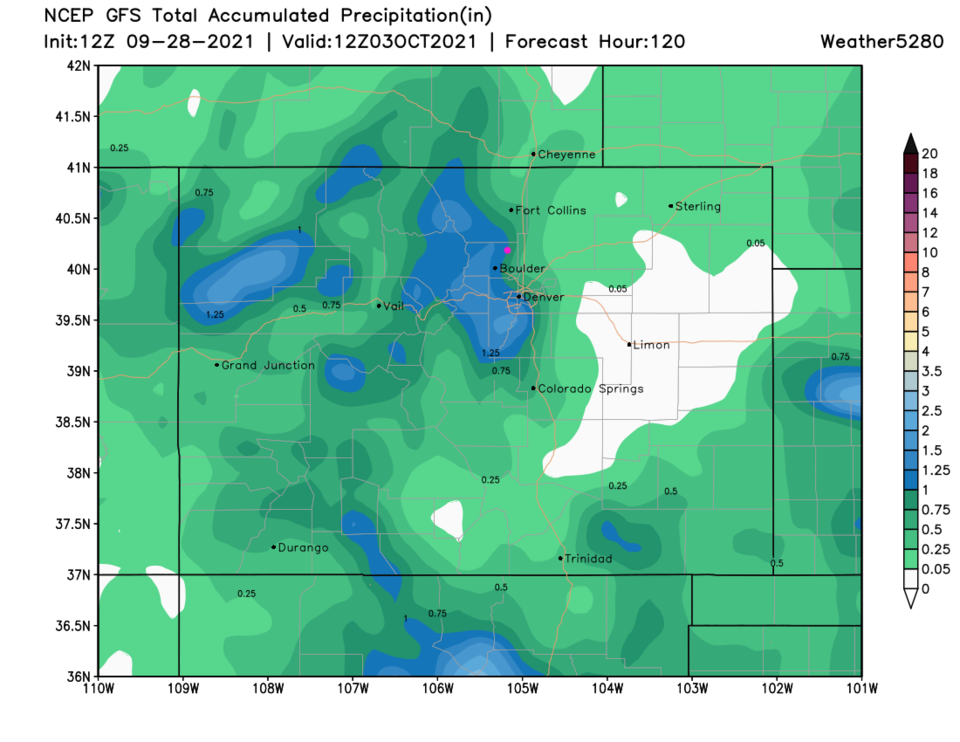
Say goodbye to the heat!  A cold front arrives around 3-4pm today and temperatures will begin to drop (blue line Figure 1 update). The temperature drop from Monday to Wednesday will be about 25-30F. Rain chances arrive with this front and with another reinforcing front that arrives Wednesday afternoon (Figure 1 update). The GFS gives us about 0.75 to 1 inch of water (very significant!! Figure 2 update). Note, the weatherunderground model keeps us below 1/4th of an inch (Figure 1 update).

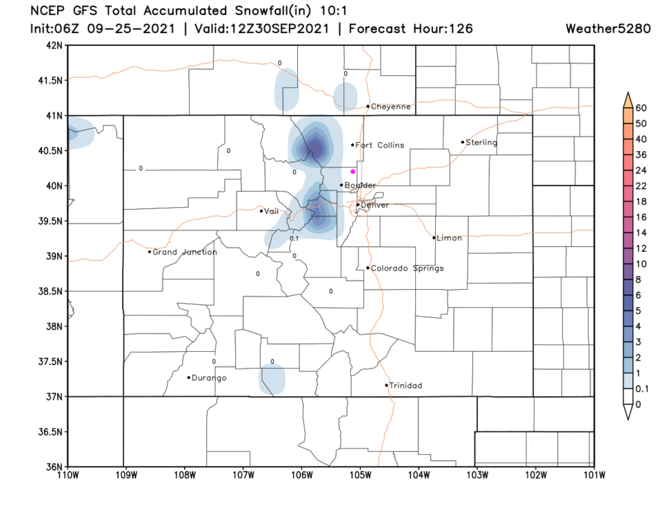
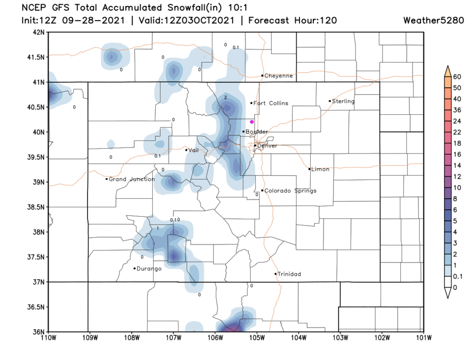
The nearby mountains will see 2-5 inches of snow at the higher elevations (Figure 3 update).  Go find those light jackets!

Figure1u_09282021
Figure 1 update: the 10 day graphical forecast for Longmont from weatherunderground.com
Figure2u_09282021
Figure 2 update: the 5 day rainfall total from the GFS and weather5280.com
Figure3u_09282021
Figure 3 update: the 5 day 10:1 ratio snowfall (snow to rain amount) from the GFS and weather5280.com

End Tuesday update.


Forecast Discussion:

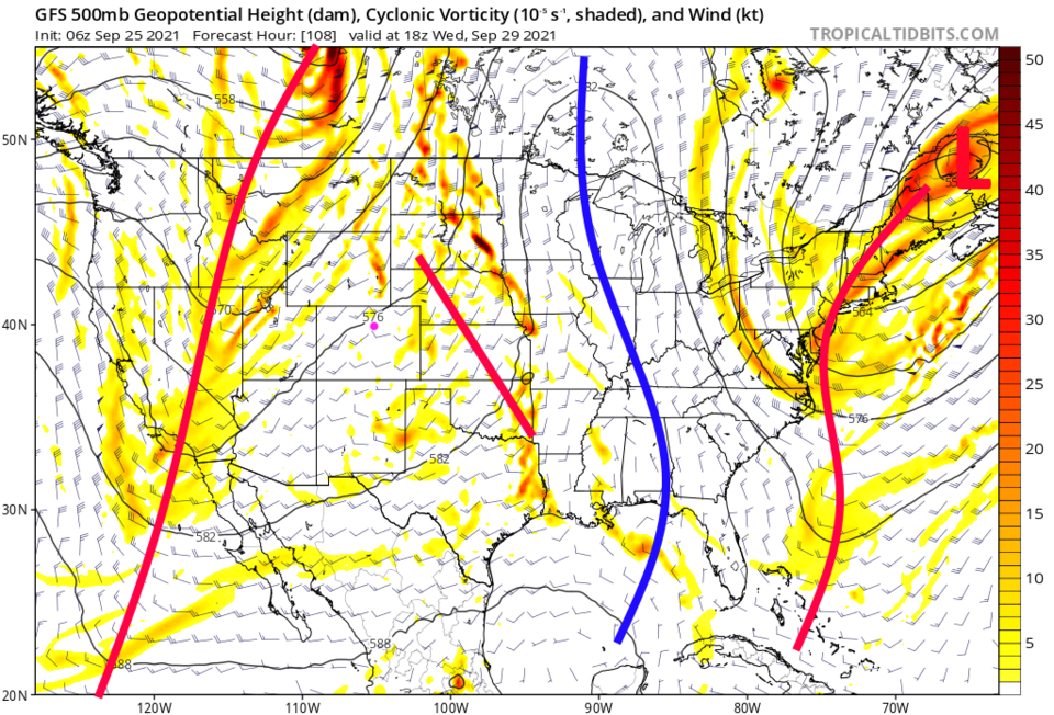
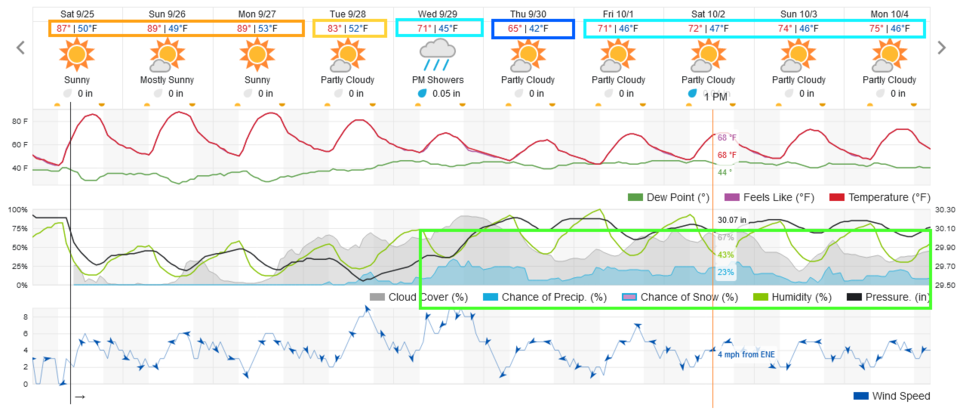
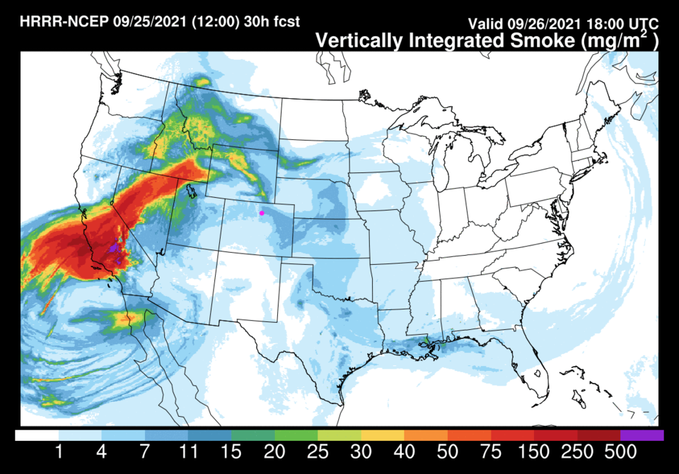
We have a big change coming in the weather. This is a new development since the model runs in this weeks video.  Through Tuesday, a big ridge remains in the west (Figure 2, blue line) and holds strong. We will see temperatures far above normal (mid 70s right now) as it does (Figure 1). Some smoke will keep leaking into Colorado from the West (Figure 3). It looks like the first cold front will arrive in the afternoon Tuesday.

Figure1_09252021
Figure 1: the 10 day graphical forecast from weatherunderground.com for Longmont, CO.
Figure2_09252021
Figure 2: the 500mb upper air forecast map for Monday noon from the GFS and tropicaltidbits.com
Figure3_09252021
Figure 3: the HRRR smoke at all levels forecast map for Sunday afternoon from NOAA.

The Longer Range Forecast:

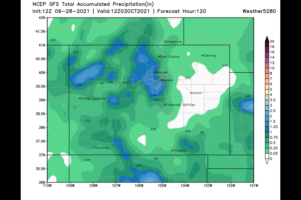
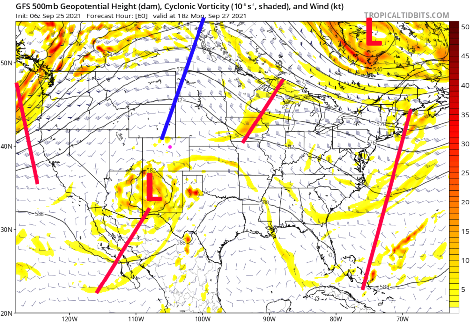
An approaching trough (red line Figure 4) will reconnect with the cutoff low in the desert southwest (Figure 2). Some good rains return to the mountains over the next five days (Figure 5) and even some snow! (Figure 6).  Return to the Longmont Leader for updates as this change approaches.

Figure4_09252021
Figure 4: the 500mb upper air forecast map for Wednesday noon from the GFS and tropicaltidbits.com
Figure5_09252021
Figure 5: the 5 day precipitation total from the GFS and weather5280.com
Figure6_09252021
Figure 6: the forecast total snowfall through Thursday noon (10:1 ratio) from the GFS and tropicaltidbits.com


About the Author: John Ensworth

John Ensworth used to work from Longmont as the PI for the NASA through the IGES (The Institute for Global Environmental Strategies). He now teaches technology, algebra, astronomy, meteorology, film school, and Lego robotics to middle/high school.
Read more


Comments


Current Weather

Mostly cloudy

Mostly cloudy

71°F

UV Index
5 Moderate
Pressure
30.2 Falling
Visibility
6 miles
Dewpoint
60 °F
Humidity
68%
Wind
NNE 2.3 mph
Gust
4.4 mph
Wind Chill
71 °F

Hourly Forecast

Today
12 PM
72°F
Mostly cloudy
Today
1 PM
76°F
Mostly cloudy
Today
2 PM
78°F
Mostly cloudy
Today
3 PM
80°F
Mostly cloudy
Today
4 PM
82°F
Mostly cloudy
Today
5 PM
84°F
Intermittent clouds
Today
6 PM
82°F
Intermittent clouds
Today
7 PM
79°F
Intermittent clouds
Today
8 PM
77°F
Intermittent clouds
Today
9 PM
73°F
Partly cloudy
Today
10 PM
69°F
Partly cloudy
Today
11 PM
65°F
Intermittent clouds

7 Day Forecast

Mostly cloudy

Saturday

84 °F

Clouds and breaks of sun; high levels of ozone will lead to poor air quality


Partly cloudy

Saturday Night

58 °F

Partly cloudy


Partly sunny w/ showers

Sunday

94 °F

Partly sunny with a passing shower in the afternoon


Partly cloudy

Sunday Night

61 °F

Partly cloudy


Mostly cloudy

Monday

91 °F

Considerable cloudiness


Mostly clear

Monday Night

60 °F

Clear to partly cloudy


Intermittent clouds

Tuesday

92 °F

Sun through high clouds


Partly cloudy

Tuesday Night

58 °F

Partly cloudy


Intermittent clouds

Wednesday

84 °F

Not as warm with times of clouds and sun; a thunderstorm in spots in the afternoon


Intermittent clouds

Wednesday Night

58 °F

An evening thunderstorm; otherwise, partly cloudy


Sunrise and Sunset

Sunrise
5:41 AM
Sunset
8:30 PM

Based on AccuWeather data