Skip to content
Join our Newsletter

Longmont Weather Forecast: Mostly cool and mostly smoke-free weather for start of week

In brief:

Cold fronts are finally cooling us to, or below, normal this week, and are bringing in fresh clean Canadian air.

Forecast discussion:

The flow across the state is out of the northwest or west-northwest this week. Ripples in that flow will bring down a couple of additional cold fronts that deliver wind and cooler temperatures (Figure 1 below).


figure1_10122020
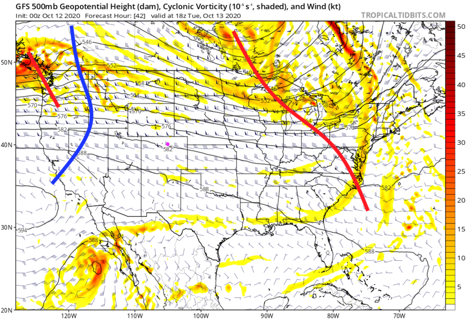
Figure 1: the 500mb upper air forecast map for Tuesday at noon from tropicaltidbits.com

This flow and the surface cold fronts have really scoured out the smoke. You get to breathe easier (unless our local fires flare up again Figure 2).


Figure2_10122020
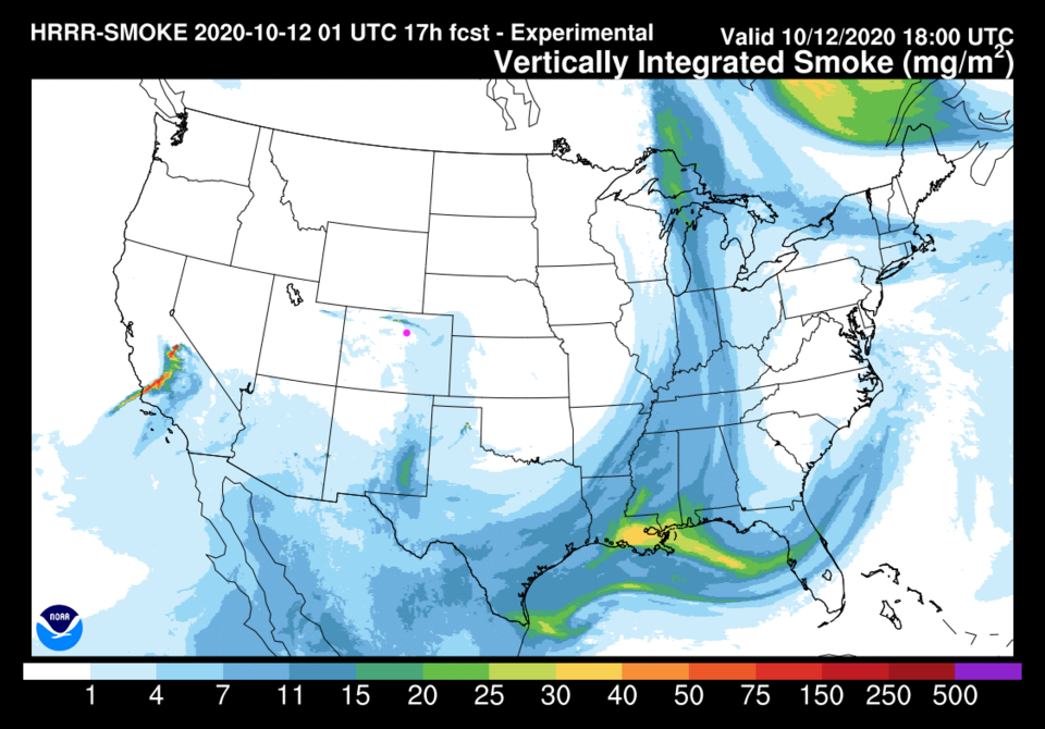
Figure 2: the HRRR smoke forecast for Monday noon from NOAA

We will warm back to just about 80 degrees Tuesday and Wednesday then our next cold front drops temperatures about 25 degrees going into Thursday. You will feel that chill!


Figure3_10122020
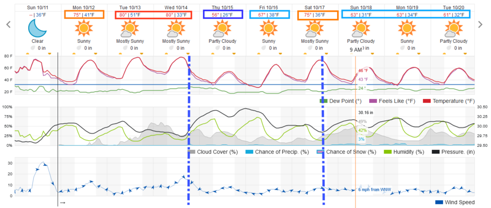
Figure 3: the 10 day graphical forecast for Longmont from weatherunderground.com


The longer-range forecast:

We climb back to the mid-70s for the start of the weekend, then another afternoon cold front drops us 10 degrees into Sunday (Figure 3). Neither the weatherunderground model (Figure 3) nor the GFS (Figure 4) give us any rain over the next 10 days. Hang in there, it will rain or snow someday. (If you were watching, our fantasy snowstorm for the time period around Oct. 20 covered in the last forecast discussion HAS vanished as well. Oh well.)


Figure4_10122020
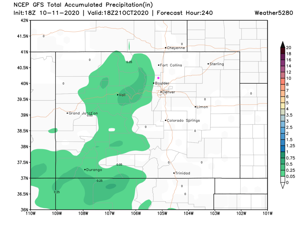
Figure 4: the 10 day precipitation total forecast from the GFS and weather5280.com


About the Author: John Ensworth

John Ensworth used to work from Longmont as the PI for the NASA through the IGES (The Institute for Global Environmental Strategies). He now teaches technology, algebra, astronomy, meteorology, film school, and Lego robotics to middle/high school.
Read more


Comments


Current Weather

Mostly cloudy

Mostly cloudy

76°F

UV Index
4 Moderate
Pressure
30.21 Steady
Visibility
8 miles
Dewpoint
46 °F
Humidity
35%
Wind
NE 5 mph
Gust
9.7 mph
Wind Chill
76 °F

Hourly Forecast

Today
2 PM
78°F
Mostly cloudy w/ t-storms
Today
3 PM
76°F
Intermittent clouds
Today
4 PM
74°F
Intermittent clouds
Today
5 PM
71°F
Intermittent clouds
Today
6 PM
68°F
Mostly cloudy w/ t-storms
Today
7 PM
65°F
Intermittent clouds
Today
8 PM
63°F
Intermittent clouds
Today
9 PM
60°F
Intermittent clouds
Today
10 PM
58°F
Intermittent clouds
Today
11 PM
56°F
Intermittent clouds
Tomorrow
12 AM
55°F
Mostly cloudy w/ t-storms
Tomorrow
1 AM
54°F
Intermittent clouds

7 Day Forecast

Partly sunny w/ t-storms

Tuesday

78 °F

Not as warm with times of clouds and sun; a thunderstorm in the area this afternoon; thunderstorms can bring gusty winds, hail and localized flooding


Mostly cloudy w/ t-storms

Tuesday Night

51 °F

A thunderstorm this evening; otherwise, increasing clouds


Mostly cloudy w/ t-storms

Wednesday

72 °F

Some sun, then turning cloudy with a couple of thundershowers in the afternoon


Partly cloudy w/ t-storms

Wednesday Night

50 °F

A couple of showers and a thunderstorm in the evening; otherwise, clearing


Mostly sunny

Thursday

72 °F

Mostly sunny and pleasant


Clear

Thursday Night

45 °F

Clear


Sunny

Friday

81 °F

Plenty of sunshine


Partly cloudy

Friday Night

47 °F

Partly cloudy


Mostly sunny

Saturday

85 °F

Mostly sunny


Clear

Saturday Night

53 °F

Clear


Sunrise and Sunset

Sunrise
6:42 AM
Sunset
7:08 PM

Based on AccuWeather data