The video forecast for this week.
In brief:
We're seeing a roughly nine hour delay in the storm, but 1.5 to 2.5 feet around Longmont is likely.
Sunday PM Update:
Snow continues off and on, getting lighter, through 2-3am Monday. Now the winds are kicking up prompting the NWS to issue a:
...BLIZZARD WARNING IN EFFECT UNTIL MIDNIGHT MDT TONIGHT...
* WHAT...Blizzard conditions ongoing. Additional snow accumulations
of 2 to 6 inches, with storm totals of 14 to 24 inches, heaviest
Boulder to Fort Collins corridor. Winds gusting as high as 45 mph.
* WHERE...Fort Collins, Boulder and the western suburbs of Denver,
Denver, Castle Rock, and Greeley.
* WHEN...Until Midnight MDT tonight.
* IMPACTS...Do not travel. Blowing and drifting snow will
significantly reduce visibility with whiteout conditions at
times. Scattered power outages can be expected.
PRECAUTIONARY/PREPAREDNESS ACTIONS...
Travel should be restricted to emergencies only. If you must travel,
have a winter survival kit with you. If you get stranded, stay with
your vehicle. The latest road conditions for Colorado can be
obtained by calling 5 1 1 or by going to www.cotrip.org
End Sunday PM update.
Sunday AM Update:
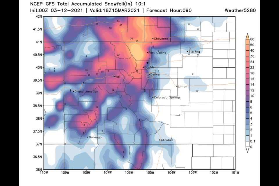
The storm held off for almost a full day but it eventually arrived. Temperatures were marginal so snow to liquid ratios were below 10:1 (probably more like 8:1) and the weight of later snow compacted earlier snow, still.... there is a lot of snow out there. Looking statewide, much of the state received 2-10 inches so far (and the storm is still going to town). Around Boulder and Larimer counties, 7-17 inches is common. We do see 17-27 in totals around Ft. Collins and northward (Figure 1 update).
In Boulder County (Figure 2 update) most received 7-12 inches. And there is still more to come. Snow should taper off around 8-10 p.mm tonight.
The GFS still thinks a foot or more will fall today to our west and throughout the foothills (Figure 3 update). Notice the warm temperatures to our east cuts off snowfall amounts very sharply near I-25. More realistically, weatherunderground is predicting another 4-6 inches today giving us 1.5 feet of snow.
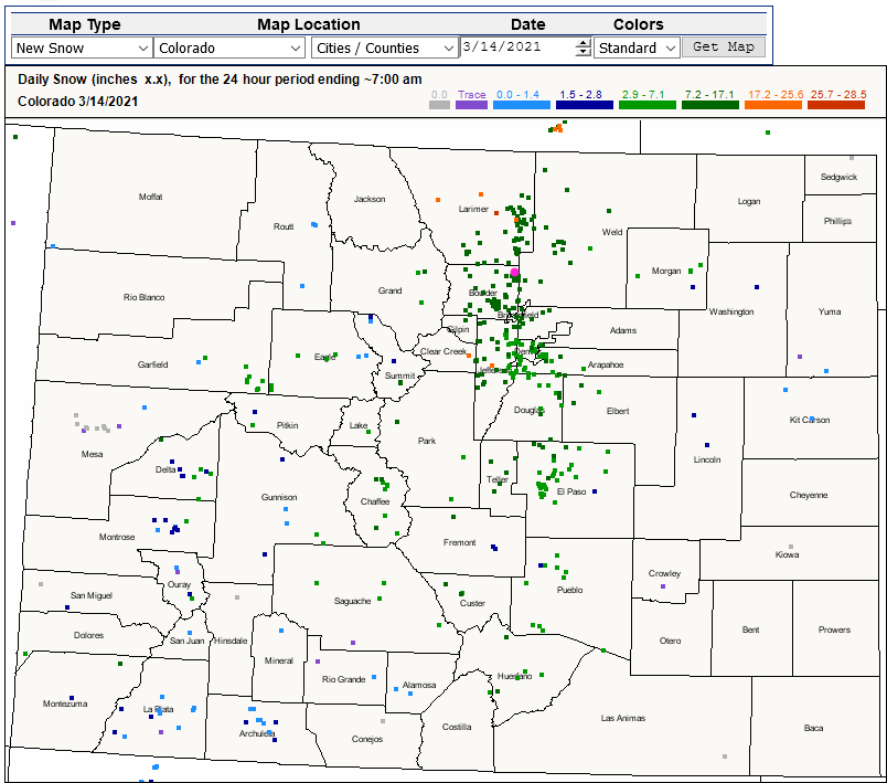 Figure 1 update: the statewide CoCoRaHS snowfall reports as of Sunday 7am.
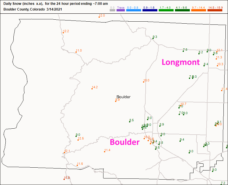 Figure 2 update: the Boulder Co. CoCoRaHS snowfall reports as of Sunday 7am.
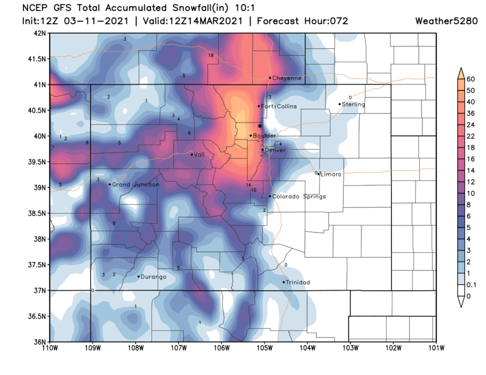 Figure 3 update: the GFS 10:1 snowfall ratio prediction through Tuesday from weather5280.com
End Sunday AM update.
Saturday AM Update:
All forecasting outlets are holding firm on the storm and snowfall potential. The system has slowed further, but a large wave of rain and snow is roaring northward passing Pueblo as of 9am. The main storm impact will be felt beginning 12p to 1pm and continuing to around 9pm Sunday . The weatherunderround model has backed off from 25-30 inches (at max) to 18-22 inches in town. More rain will be seen out on the Plains and relatively close to I-25. That same model has backed off on Denver to around 17-ish inches. Bottom line, the storm is coming in a bit later but basically the same impact on the region is expected.
End Saturday AM update.
Winter storm warning:
URGENT - WINTER WEATHER MESSAGE
National Weather Service Denver CO
229 PM MST Thu Mar 11 2021
...POWERFUL WINTER STORM ON TRACK FOR THIS WEEKEND...
.A significant late-season winter storm will move across the Desert Southwest Friday to near the Four Corners region by Saturday, and then track east/northeast across southeast Colorado Sunday. This track will bring significant snowfall to much of northeast and north-central Colorado, and likely result in difficult if not impossible travel from Saturday afternoon through Sunday and Sunday night. The most severe conditions from deep accumulating snow will likely occur in and near the Front Range mountains and foothills, where 2 to 4 feet of snow may fall, and along the Interstate 25 urban corridor, where up to 2 feet of snow can be expected. Temperatures will be warm enough to bring a mix of rain and snow to areas east of a Greeley to Limon line Saturday into Saturday evening, but temperatures should turn cold enough there Saturday night into Sunday for mostly snow. Winds are also expected to increase by Sunday, with blowing and drifting snow developing across the plains.
...WINTER STORM WARNING IN EFFECT FROM 5 AM MST SATURDAY TO 6 AM MDT MONDAY...
* WHAT...Heavy snow possible. Total snow accumulations of 14 to 24 inches possible. Accumulations up to 30 inches possible near Boulder and Fort Collins. Winds could gust as high as 35 mph.
* WHERE...Fort Collins, Boulder and the western suburbs of Denver, Denver, Castle Rock, and Greeley.
* WHEN...From 5 AM MST Saturday to 6 AM MDT Monday.
* IMPACTS...Travel could be very difficult to impossible.
* ADDITIONAL DETAILS...Finish preparation for this storm by Friday. Conditions will likely deteriorate quickly Saturday as the storm arrives.
PRECAUTIONARY/PREPAREDNESS ACTIONS...
If you must travel, keep an extra flashlight, food, and water in your vehicle in case of an emergency. The latest road conditions for Colorado can be obtained by calling 511 or by going to www.cotrip.org.
___________________________________________________________________________
Forecast discussion:
The center of the low by Sunday morning is very close to ideal for maximum Front Range snowstorms (Figure 1). Not unlike a tropical system, this big low is drifting its own way under a big ridge over the West. It looks like it has slowed a bit more than expected. After a rainy Friday, snow should begin to pick up pre-dawn Saturday (Figure 2). The really heavy snow rates may hold off until later morning or even early afternoon. Because of this, some of the bigger snowfall accumulations will occur on Sunday as well.
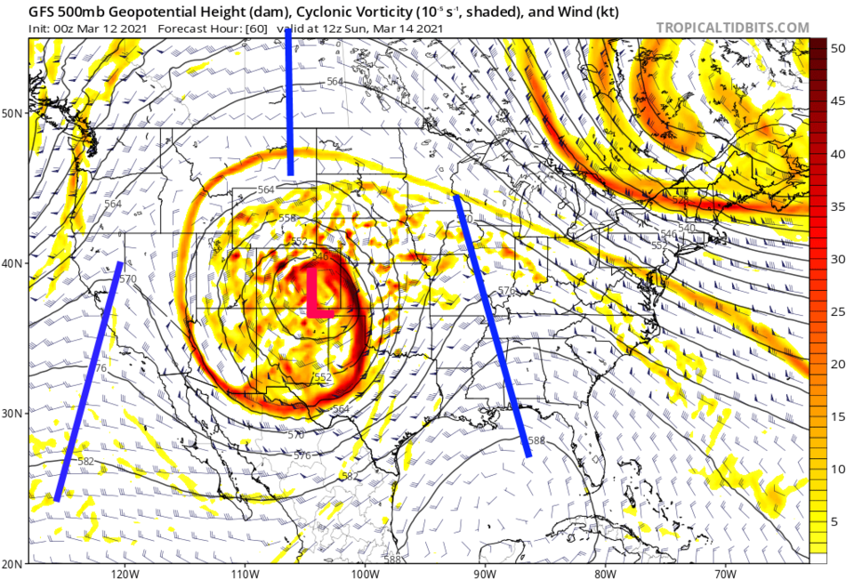 Figure 1: the 500mb upper air forecast map for Saturday morning from the GFS and tropicaltidbits.com
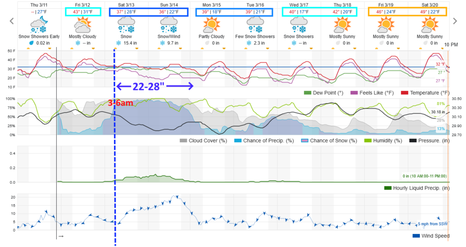 Figure 2: the 10-day graphical forecast from weatherunderground.com for Longmont.
Snowfall roundup:
The NWS above gives Longmont roughly 24 to 28 inches.
Weatherunderground: 22 to 28 inches (Figure 2).
The GFS (Figure 3 with more rain upfront): 10 to 14 inches. (Notice the 1to 3 inches of rain out on the Plains from the GFS - Figure 4).
The GEM/Canadian (Figure 5): 25 to 39 inches.
The outlier that the NWS does not think is on track at all is the NAM (Figure 6): 6 to 8 inches.
The great forecasters at weather5280.com itself hand-painted the map in Figure 7: Longmont gets 16 to 30 inches according to their work on the storm.
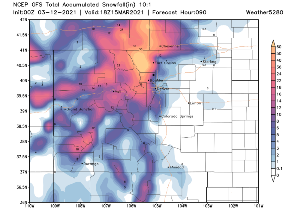 Figure 3: the 3.5-day (10:1 ratio) total snowfall forecast from the GFS and weather5280.com
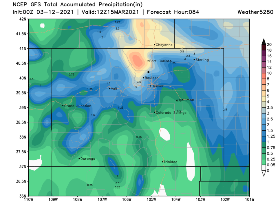 Figure 4: the 10-day (10:1 ratio) total precipitation forecast from the GFS and weather5280.com
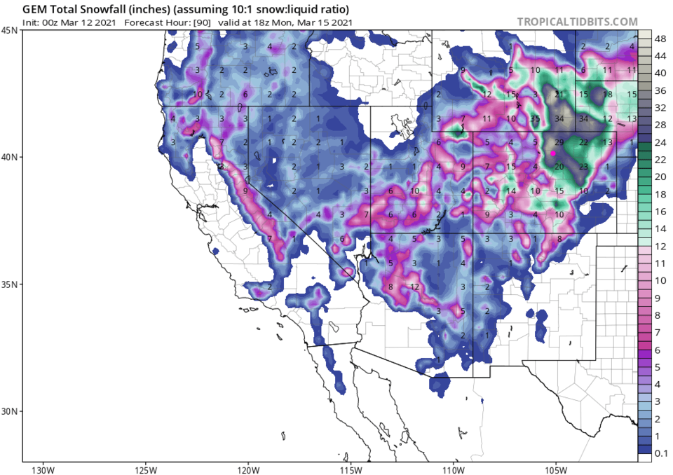 Figure 5: the 3-day (10:1 ratio) total snowfall forecast from the GEM and weather5280.com
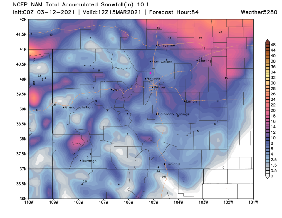 Figure 6: the 3-day (10:1 ratio) total snowfall forecast from the NAM and weather5280.com
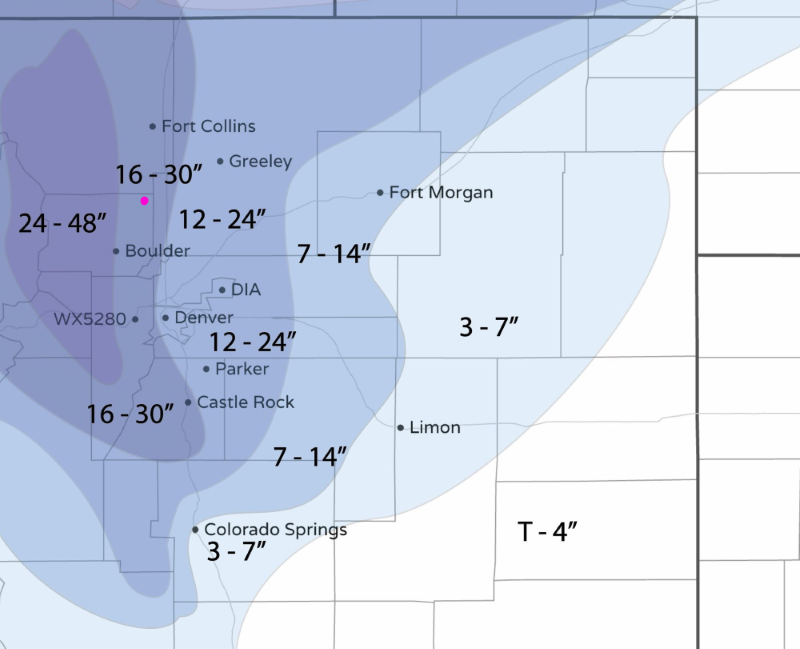 Figure 7: the snowfall forecast made by the forecasters at weather5280.com
The longer-range forecast:
Monday will quiet down a bit (Figure 2) with sinking air behind the departing system. Then another cutoff slides through in the wake of the main storm and we see another 2 to 4 inches of snow before returning to the upper 40s by the end of the week.
Stay safe everyone. I'll be on the road the next two days (yep, getting outta the way of the storm). I'll update as I need and can.


