In Brief:
A smaller amount of snow Wednesday/Thursday becomes a warm-up to a beautiful weekend.
Tuesday Update:
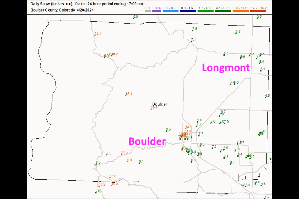
Looking back before we look forward, the snowfall reports from Monday's storm are impressive. Longmont received five to seven inches across town (Figure 3 update). Boulder came very close to a foot of snow in places. That was just half of our "big" March storm.
For tomorrow, Wednesday, it looks like rain, followed shortly by snow. The storm will begin around 1 p.m. and continue into Thursday morning (Figure 4 update). The GFS (not shown) gives us a coating to an inch. Weathreundergournd seems to be in the 1/2 to 2-inch zone. I think that those totals look good, but a few lucky spots could approach 3 inches along I-25. We can handle that!
If you are tired of snow, the temperatures will rise to the 70s for the weekend. It will be perfect at the right time of the week.
 Figure 3 update: snowfall totals as of 7am Tuesday from CoCoRaHS.
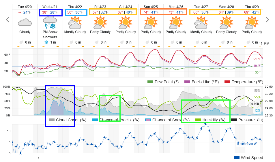 Figure 4 update: the 10 day graphical forecast from weatherunderground for Longmont, CO.
End Tuesday Update:
Sunday 2nd Update:
The National Weather Service has issued a Winter Weather Advisory for 3-6 inches of snow from 3pm Monday to 3am Tuesday. Noting that the Monday PM commute will be hazardous. This is a similar amount of snow as forecasted below, but shifted forward about 3 hours. Stay warm and safe!
End Sunday 2nd update.
Sunday Update:
The models have been very steady and consistent with the snow on Monday. The weatherunderground model has had 4-5 inches predicted for days (Figure 1 update). The GFS (Figure 2 update) gives our region 4-6 inches with a bulls-eye over Boulder (more like 8-10inches). The Canadian model (not shown) gives us 3-5 inches of snow. The forecasters at weather5280 (not shown) give us about 4-5 inches with 6 inches in Boulder.
If the timing on weatherunderground is correct (Figure 1 update) - the main snow threat will run from noon to midnight Monday. The afternoon commute could be quite an adventure.
 Figure 1 update: the 10 day graphical forecast from weatherunderground.com for Longmont, CO.
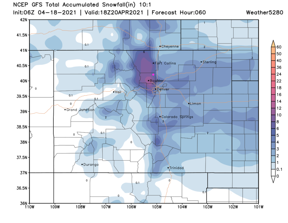 Figure 2 update: the 10:1 ratio snowfall forecast from the GFS through Tuesday noon.
End Sunday Update.
Forecast Discussion:
First, let's see what we picked up Thursday into Friday. The forecast was for 3 to 5 inches along much of U.S. 25 with more in the foothills (and on the Plains, not shown). Figure 1 shows Longmont received about 3.5 to 6 inches of snow. Boulder did better with 4 to 7 inches in spots. We received about two-thirds of an inch of moisture from this storm.
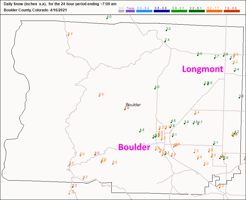 Figure 1: CoCoRaHS snowfall reports as of 7am Friday.
After another dusting to an inch or overnight Friday (Figure 6) snowfall will continue on the Western slopes, and the NCEP forecasters think we'll see some more snow Saturday afternoon into Sunday morning (Figure 2 and Figure 3). Figure 6 doesn't show much, if any, falling in town until Monday. Interesting differences! From Friday afternoon to Sunday afternoon, the GFS (Figure 4) gives us a coating to an inch of snow with 2 to 4 inches up in the hills.
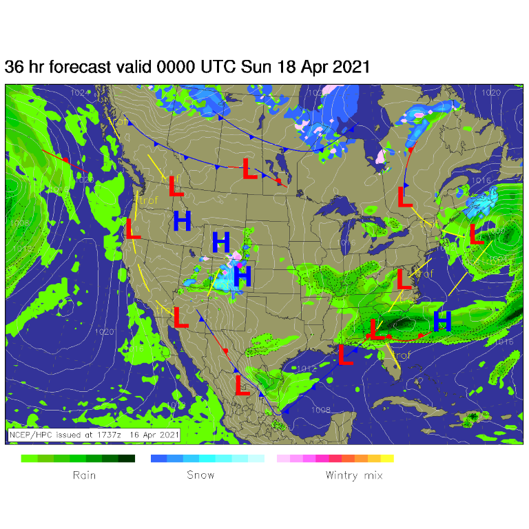 Figure 2: the surface forecast for Saturday PM by NCEP.
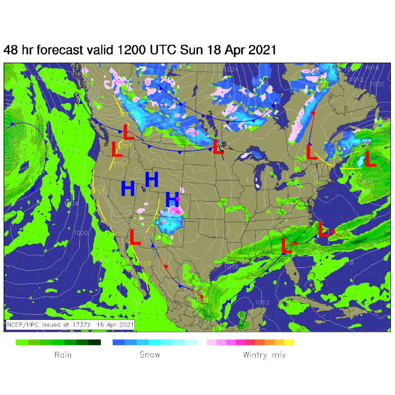 Figure 3: the surface forecast for Sunday morning by NCEP.
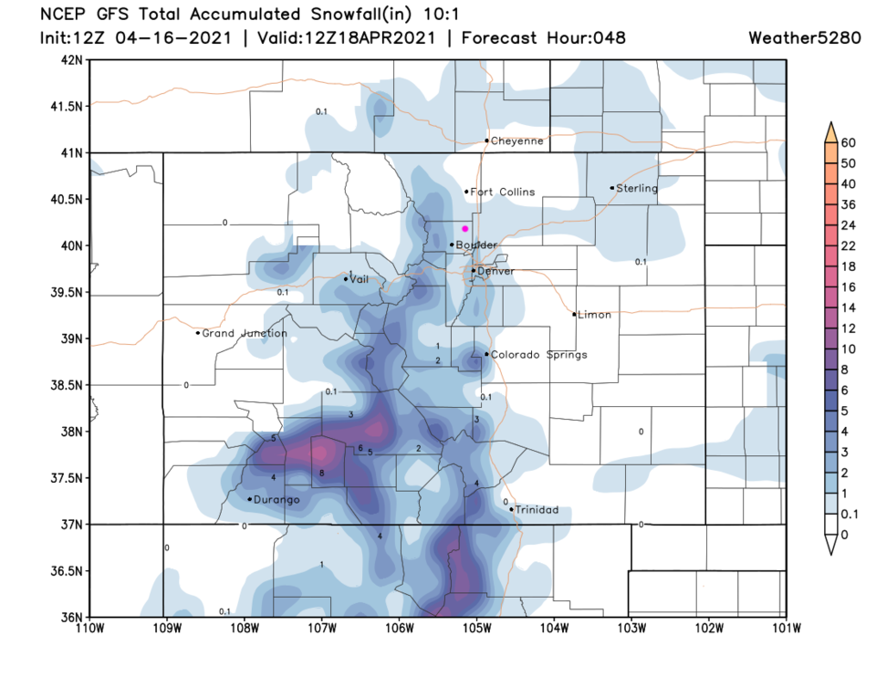 Figure 4: the 10:1 snowfall forecast through Sunday PM by the GFS and weather5280.com
The Longer Range Forecast:
The next trough will approach the state, Monday, with significant energy associated with it (Figure 5). The weatherunderground model shows snow beginning pre-dawn Monday with 3 to 5 inches falling again (see Figure 6).
This certainly may change in the forecast between now and Sunday night. We'll keep an eye on it here. The GFS adds about 4 to 6 inches of snow (more just to the west) with this next system.
Later in the week, temperatures finally warm to closer to normal and rain showers are possible every day, starting Wednesday. Over the next ten days, we should pick up about an inch of additional water. Great news!
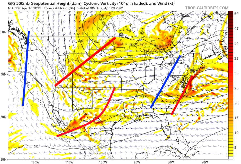 Figure 5: the 500mb forecast from the GFS for Monday night from tropicaltidbits.com
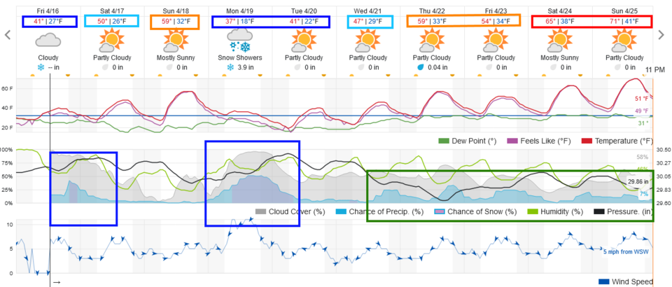 Figure 6: the 10 day graphical forecast from weatherunderground.com for Longmont, CO.
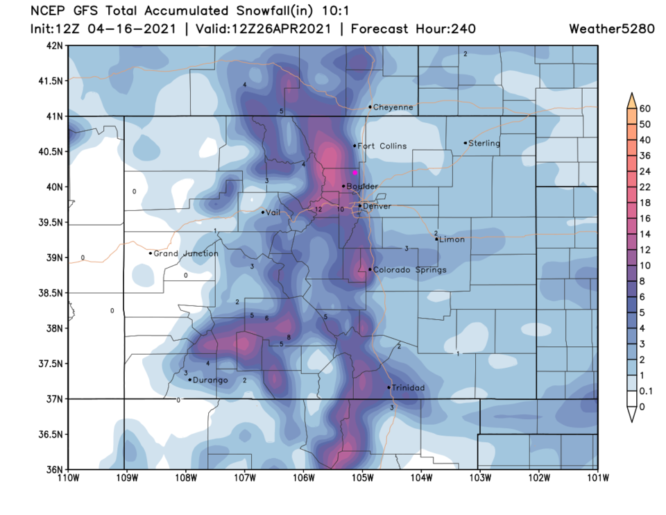 Figure 7: the 10:1 snowfall forecast over the next 10 days by the GFS and weather5280.com
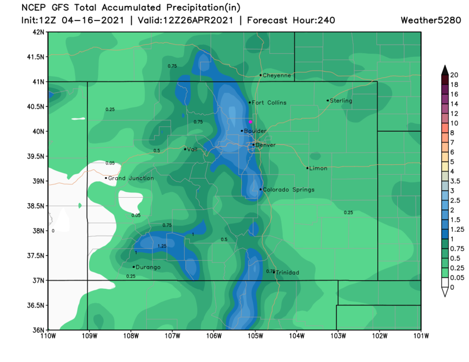 Figure 8: the total water content/rainfall forecast over the next 10 days by the GFS and weather5280.com


