This weeks Video forecast
In Brief:
Probable record cold will help produce more than six inches of snow.
Sunday PM update:
A big "dry slot" pulled into the storm system last night greatly cutting off potential snow. The cold came as advertised, but my snow forecast was a BUST! the best in my Snowfall Roundup below was the forecasters at weather5280.com, but they still over estimated. The actual reports showed 1-2.5 inches across town. The mid-week storm looks to be similar to this. We'll see!
With clearing skies, a temperature around -12 to -14 is probable Monday morning which should break the record of -10.
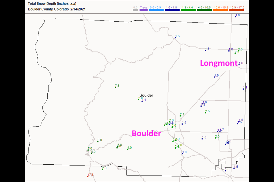
 Figure 3 update: the CoCoRaHS total snow as of 7am Sunday.
End Sunday update.
Saturday PM update:
The National Weather Service has issued the following:
...WIND CHILL ADVISORY IN EFFECT UNTIL 11 AM MST MONDAY...
...WINTER WEATHER ADVISORY REMAINS IN EFFECT FROM 5 PM THIS
AFTERNOON TO 11 AM MST SUNDAY...
* WHAT...For the Winter Weather Advisory, snow expected. Total
snow accumulations of 3 to 6 inches. For the Wind Chill
Advisory, very cold wind chills. Wind chills as low as 25 below
zero.
* WHERE...Portions of north central and northeast Colorado.
* WHEN...For the Wind Chill Advisory, until 11 AM MST Monday.
For the Winter Weather Advisory, from 5 PM this afternoon to
11 AM MST Sunday.
* IMPACTS...Plan on slippery road conditions. The dangerously
cold wind chills could cause frostbite on exposed skin in as
little as 10 minutes. Frostbite and hypothermia are possible
if precautions are not taken. Roads will likely become slick
and hazardous.
PRECAUTIONARY/PREPAREDNESS ACTIONS...
Slow down and use caution while traveling.
Use caution while traveling outside. Wear appropriate clothing, a
hat, and gloves.
The latest road conditions for the state you are calling from can
be obtained by calling 5 1 1.
The latest snowfall forecasts are: The HRRR (Figure 1 update) through 5am MT gives us 1-2 inches of snow. The 3 day total through noon Monday at at 15:1 ratio is 5-8 inches (Figure 2 update).
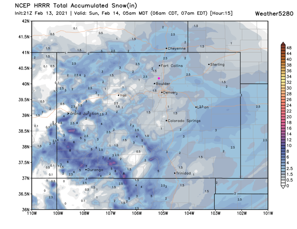 Figure 1 update: the HRRR snowfall forecast through 5am Sunday from weather5280.com
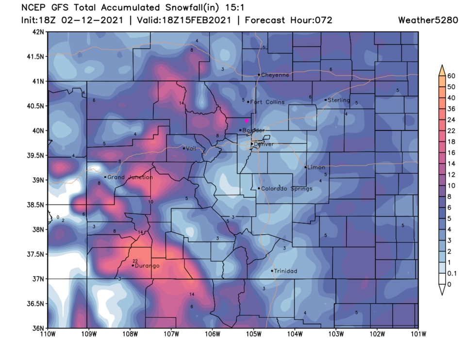 Figure 2 update: the GFS 15:1 ratio snowfall total through noon Monday from weather5280.com
End Saturday PM update.
Forecast Discussion:
A "polar vortex" or a blob of cold winter air from the Arctic region is making a trip down into the United States this weekend, bringing a serious chill to most of the nation. This weekend will see highs in the single digits and lows well below zero in Colorado (Figure 1 below). The record lows for this time of year are really low, but we may break the record Sunday night into Monday morning. A storm system will cross the state Saturday night into Sunday morning giving us six to nine inches of snow. Another system, hitting Tuesday through Thursday, will give us half to the same amount again.
Record low Saturday -14 1905 Forecast -6
Record low Sunday -10 1903 Forecast -16 New Record?!
Record low Monday -20 1881 Forecast 0
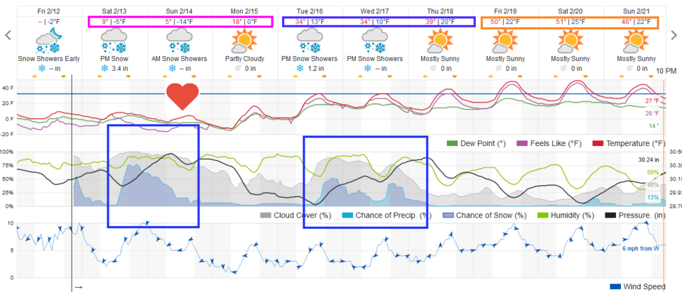 Figure 1: the 10 day graphical forecast from weatherunderground.com for Longmont, CO.
What follows is a sequence of maps that show the abnormally cold air (the brightest pink is over 40 degrees below normal). At first (Figure 2), the dense frigid air is so heavy and shallow, it can't make it up into the mountains or cross the Rockies (Figure 2). Riding in from the west is the storm system that will begin to pull moisture up and over this cold air (Figure 3). You can see the center of the coldest air up north of Minnesota and the fetch of extremely cold air (black arrows) pouring down into the Western and central parts of the nation (Figure 4).
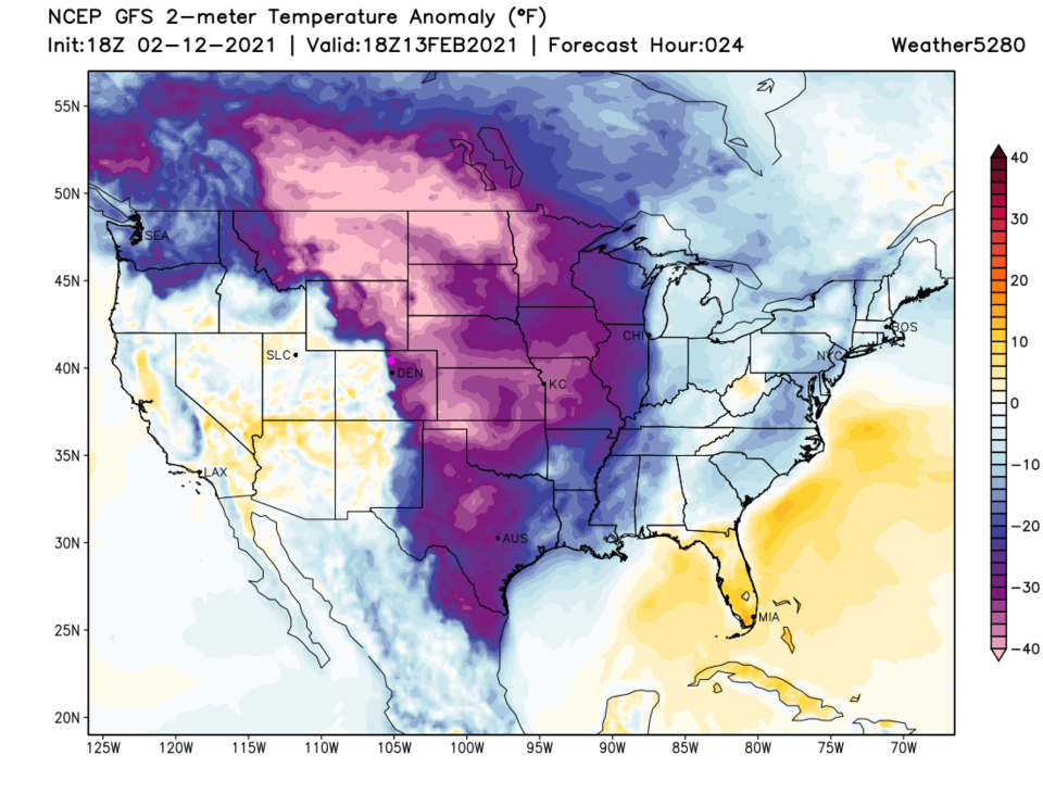 Figure 2: the temperature anomaly (departure from normal) for Saturday noon from weather5280.com
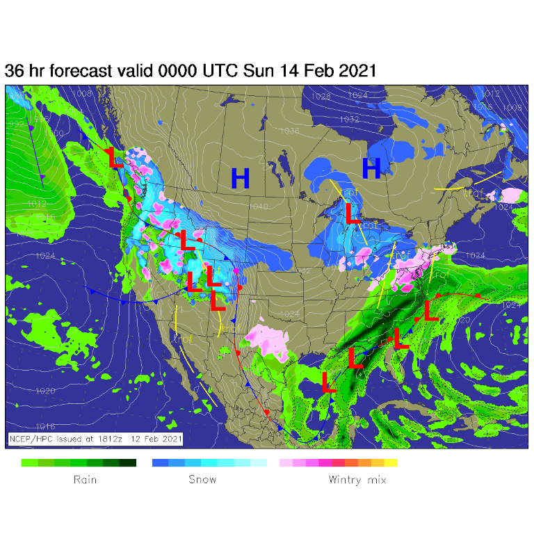 Figure 3: the forecast surface analysis for Saturday night from NCEP.
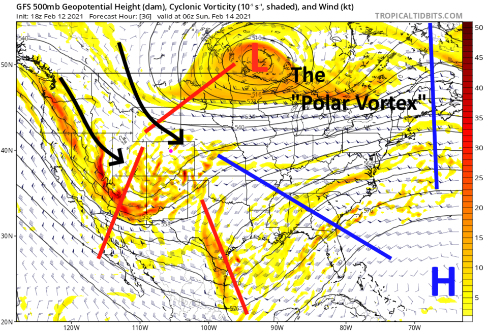 Figure 4: the 500mb upper air forecast map for Friday morning from the GFS and tropicaltidbits.com
By Sunday, the amount of cold air pouring into the nation increases significantly. The air can now pour over and around the Rockies cooling nearly everyone but the New England states to a little or a lot below normal (Figure 5). Widespread heavy snow is falling across Wyoming to Arizona and into Oklahoma with an ice storm again in north Texas (Figure 6). On Monday, the bitter cold air is still sinking southward into Mexico but keeping areas east of the Rockies amazingly cold (Figure 7).
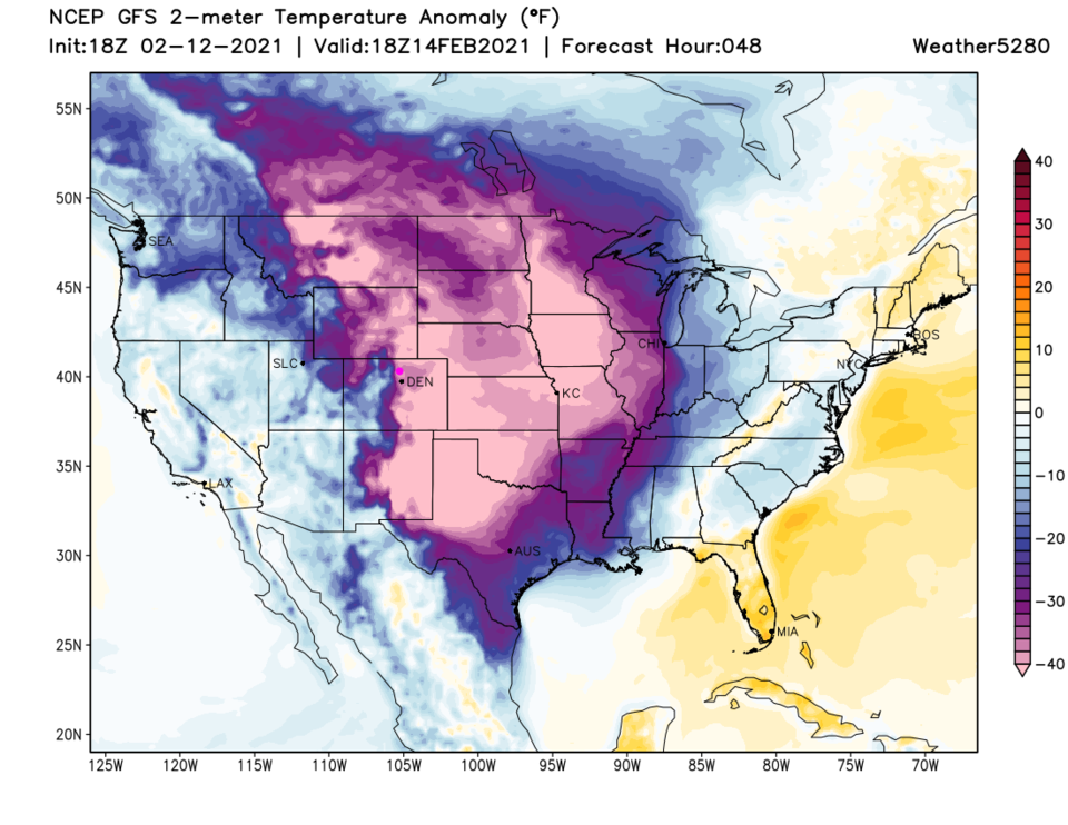 Figure 5: the temperature anomaly (departure from normal) for Sunday noon from weather5280.com
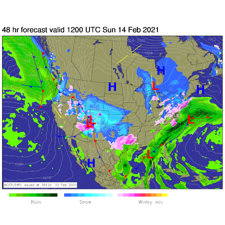 Figure 6: the forecast surface analysis for Sunday morning from NCEP.
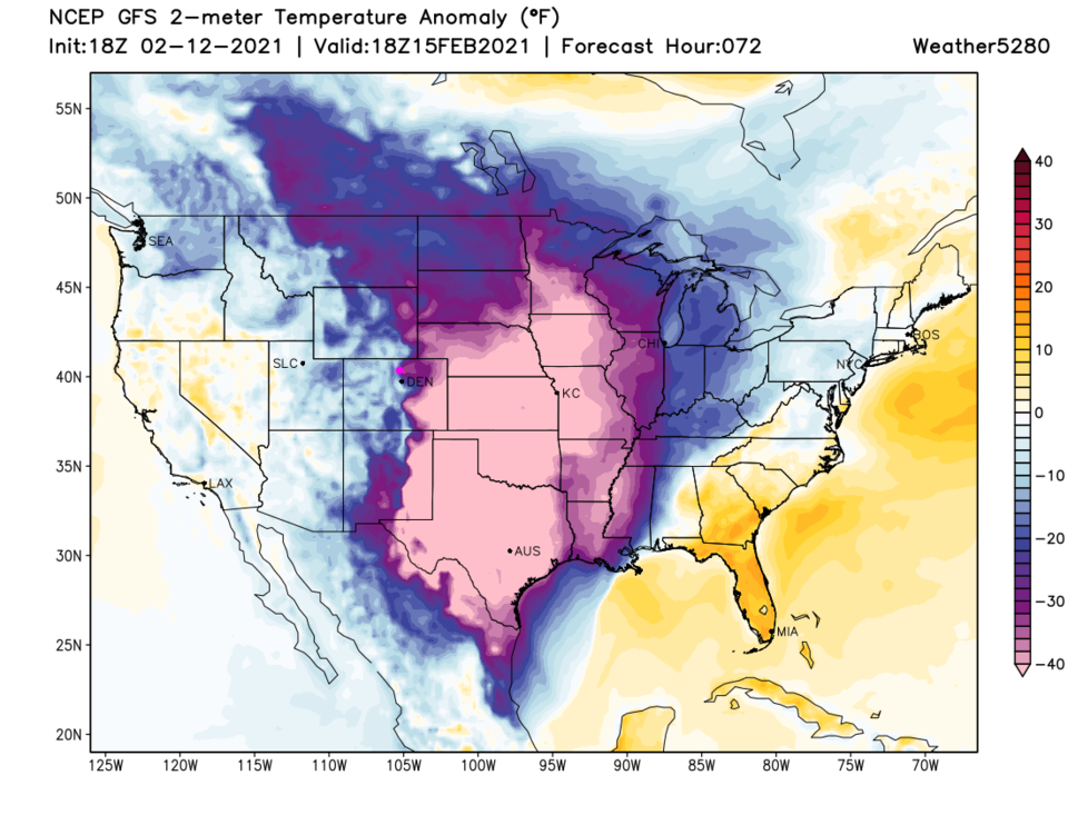 Figure 7: the temperature anomaly (departure from normal) for Monday noon from weather5280.com
Snowfall Roundup:
The GFS through Monday (Figure 8) gives Longmont 6-8 inches.
The NAM through Monday (Figure 9) gives us 10-12 inches.
The forecasters at Weather5280.com (Figure 10) give us 3-7 inches; Weatherundergound (Figure 1) 3-5 inches.
I have downloaded the 15:1 ratio snowfall maps, not the usual 10:1 ratio maps (which means 1 inch of liquid fluffs up to 15 inches of snow) because of the extremely low temperatures. Snow depth for the same amount of water will be more significant due to the cold.
My forecast is for 6-9 inches.
 Figure 8: the 15:1 ratio total snowfall forecast from the GFS and weather5280.com through Monday noon.
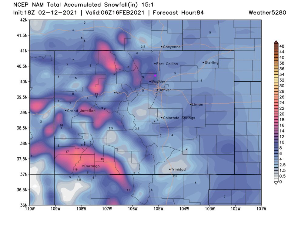 Figure 9: the 15:1 ratio total snowfall forecast from the NAM and weather5280.com through Monday noon.
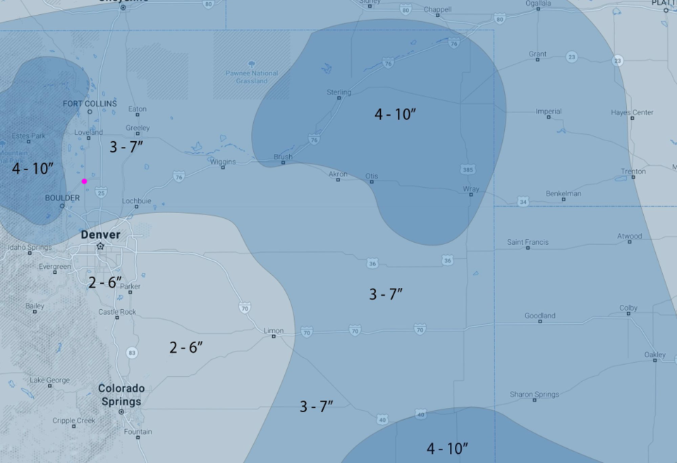 Figure 10: the snowfall forecast made by the forecasters at weather5280.com
The Longer Range Forecast:
We finally see temperatures significantly above freezing by Thursday. Our next storm may give us 2-5 inches Tuesday/Wednesday but it is hard to 'call' the next storm before the 'current' storm happens. The 10 day GFS snowfall total is 8-12 inches. Welcome to some real winter!
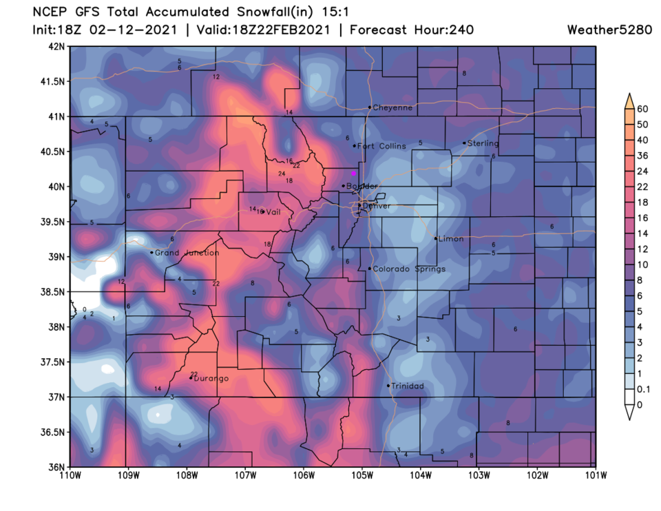 Figure 11: the 10 day (10:1 ratio) total snowfall forecast from the GFS and weather5280.com


