Skip to content
Join our Newsletter

Tuesday Update: Longmont Weather Forecast: Seasonable, but dry weather - Snow??

In Brief:

Seasonable cool weather with little rain for the next week. But rain/snow next Tuesday/Wednesday??

Tuesday update:

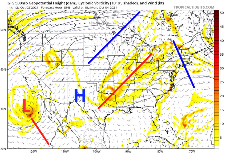
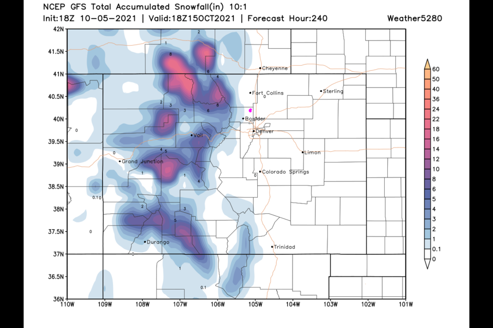
The short term forecast, seasonably warm and dry conditions, is on track.  BUT I thought I'd give everyone a heads up that the GFS model is creating a snow storm for the mountains and nearby Plains for Tuesday/Wednesday next week (Figure 1 update).  This certainly might vanish from the forecast, but it has held strong for 3 days now in the model runs.  More later!!

Figure1u_10052021
Figure 1 update: the 10 day 10:1 snowfall ratio forecast from the GFS and weather5280.com

End Tuesday update.

Forecast Discussion:

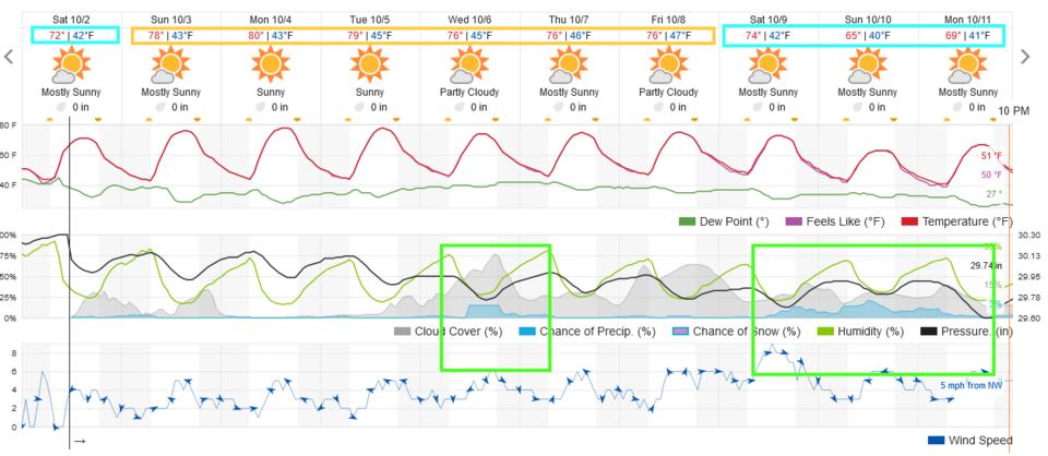
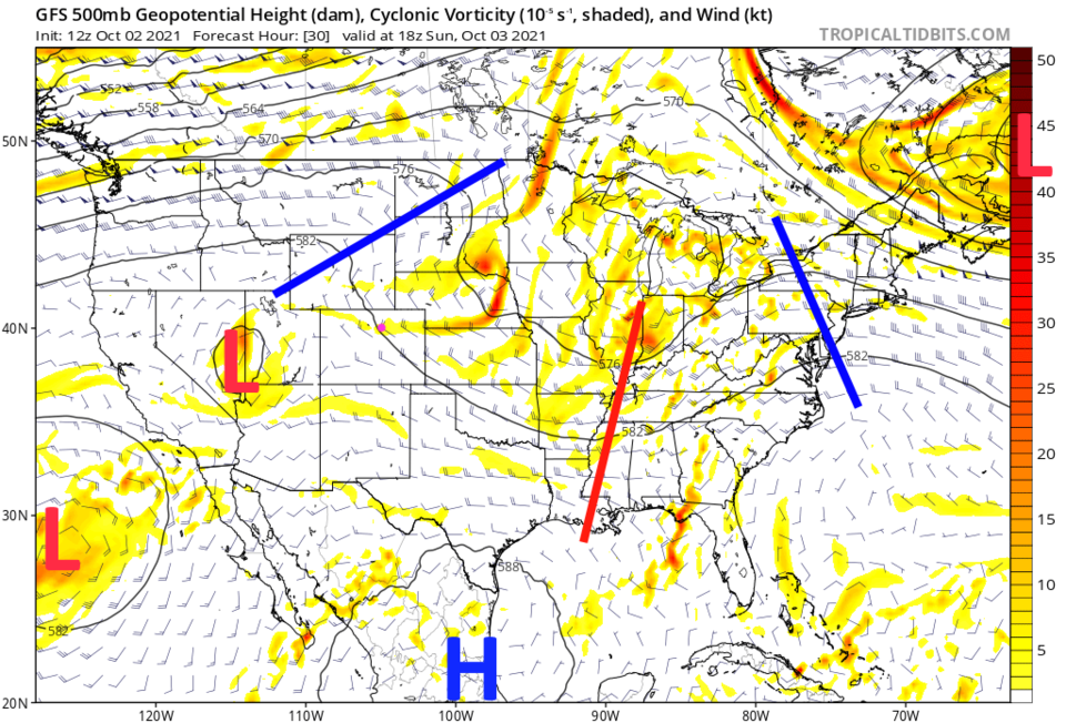
Very seasonably cool/mild weather is the story for the next 10 days (Figure 1). We have northwest winds across the state with very little moisture around (Figure 2). Enjoy a walk in this example of wonderfulness.

Figure1_10022021
Figure 1: the 10 day graphical forecast from weatherunderground.com for Longmont, CO.
Figure2_10022021
Figure 2: the 500mb upper air forecast map for Monday noon from the GFS and tropicaltidbits.com


The Longer Range Forecast:

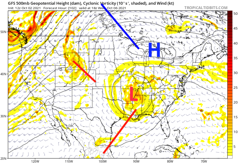
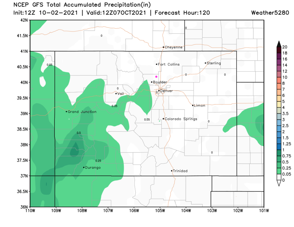
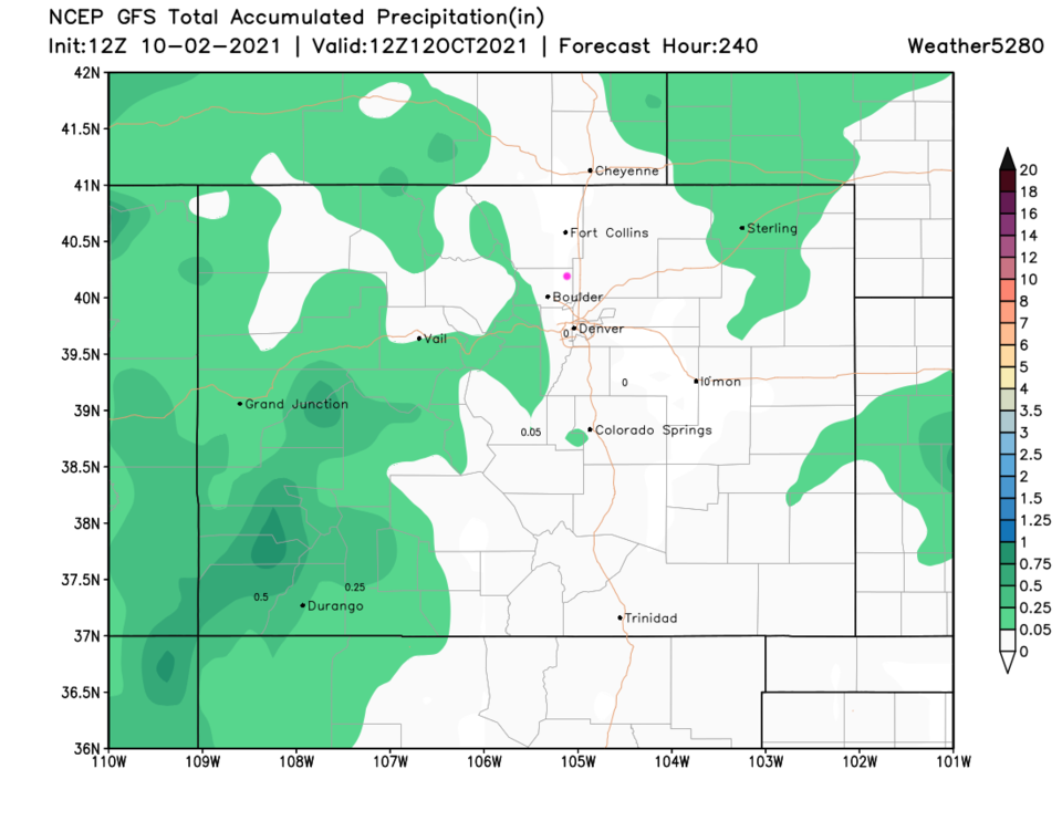
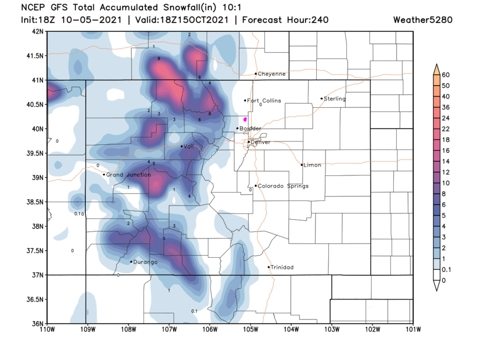
A ridge builds over the state by the start of the week, warming us to the lower 80's (Figure 3). This is only a bit above normal for this time of year. Our next (small) chance of rain arrives Wednesday with a shortwave (Figure 4 and Figure 1).  It doesn't look like a lot of moisture will fall on the plains, at present. The GFS gives only the southwestern slopes of Colorado a bit of rain over the next 5 days (Figure 5) and only the western slopes (mainly) over the next 10 days (Figure 6),


Figure3_10022021
Figure 3: the 500mb upper air forecast map for Wednesday noon from the GFS and tropicaltidbits.com
Figure4_10022021
Figure 4: the 500mb upper air forecast map for Sunday noon from the GFS and tropicaltidbits.com
Figure5_10022021
Figure 5: the 5 day precipitation total from the GFS and weather5280.com
Figure6_10022021
Figure 6: the 10 day precipitation total from the GFS and weather5280.com


About the Author: John Ensworth

John Ensworth used to work from Longmont as the PI for the NASA through the IGES (The Institute for Global Environmental Strategies). He now teaches technology, algebra, astronomy, meteorology, film school, and Lego robotics to middle/high school.
Read more


Comments


Current Weather

Sunny

Sunny

71°F

UV Index
3 Moderate
Pressure
30.21 Rising
Visibility
6 miles
Dewpoint
53 °F
Humidity
53%
Wind
ENE 1.2 mph
Gust
3 mph
Wind Chill
71 °F

Hourly Forecast

Today
9 AM
76°F
Sunny
Today
10 AM
81°F
Sunny
Today
11 AM
86°F
Sunny
Today
12 PM
89°F
Mostly sunny
Today
1 PM
91°F
Partly sunny
Today
2 PM
92°F
Partly sunny
Today
3 PM
92°F
Mostly cloudy w/ showers
Today
4 PM
93°F
Mostly cloudy
Today
5 PM
93°F
Mostly cloudy
Today
6 PM
91°F
Cloudy
Today
7 PM
89°F
Cloudy
Today
8 PM
85°F
Partly sunny

7 Day Forecast

Mostly cloudy w/ showers

Sunday

93 °F

Thickening clouds with a passing shower this afternoon


Partly cloudy

Sunday Night

64 °F

Partly cloudy


Intermittent clouds

Monday

95 °F

Some sun, then increasing clouds


Mostly clear

Monday Night

59 °F

Clear to partly cloudy


Intermittent clouds

Tuesday

92 °F

Sun through high clouds


Partly cloudy

Tuesday Night

60 °F

Partly cloudy


Intermittent clouds

Wednesday

72 °F

Times of sun and clouds with a thunderstorm in the afternoon; thunderstorms can bring hail and damaging winds


Mostly cloudy

Wednesday Night

58 °F

An evening thunderstorm; otherwise, mostly cloudy


Mostly cloudy

Thursday

86 °F

Warmer with variable cloudiness; a thunderstorm in spots in the afternoon


Intermittent clouds

Thursday Night

58 °F

Clearing


Sunrise and Sunset

Sunrise
5:42 AM
Sunset
8:30 PM

Based on AccuWeather data