Skip to content

Friday Update: Longmont Weather Forecast: Dry and warming conditions return

The Video Forecast for this Week

In Brief:

Dry and warm weather returns.
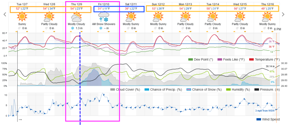
Friday Update:

DIA officially recorded 0.3 inch of snow this morning ending the snow-less streak shy of a new record.  Longmont and areas north and east stayed dry. 

End Friday update.

Thursday Update:

A strong winter storm is still entering the state today and tonight, but it will spend most of its energy and dump most of its precipitation in the mountains and western slopes.  Snow (and rain) east of the the eastern foothills will be very light.  The GFS (Figure 3 update) shows a trace to 1 inch along I-25 (and 1-3 inches in Estes Park/Nederland. The NAM (Figure 4 update) shows even less precipitation east of the Rockies with most places seeing no snow. There IS a risk that the airport might not receive measurable snow and the streak of snowless days will continue and we will break the record.

Figure3u_12092021
Figure 3 update: the 10 day 10:1 ratio snowfall total from the GFS and weather5280.com
Figure4u_12092021
Figure 4 update: the 10 day 10:1 ratio snowfall total from the NAM and weather5280.com

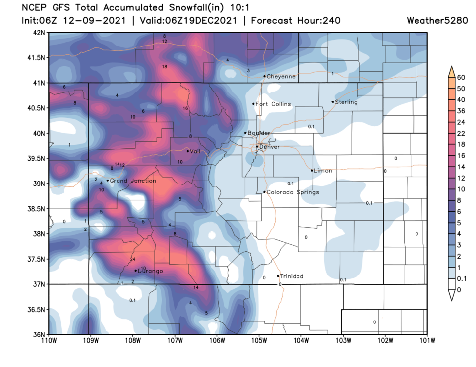
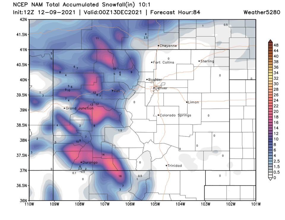
End Thursday update.
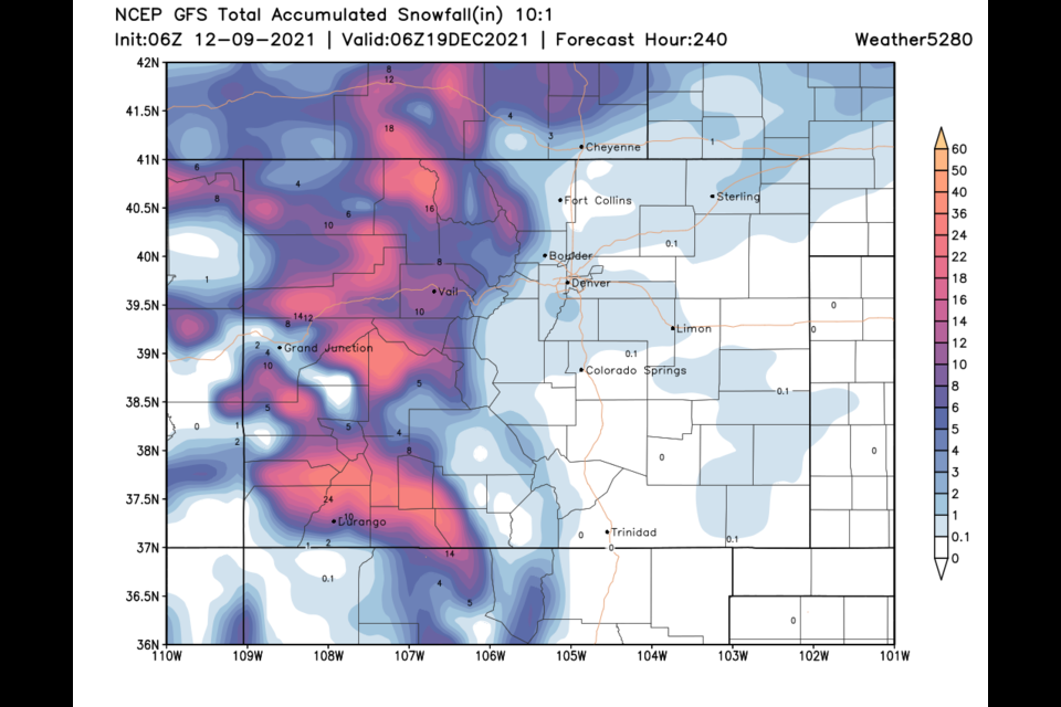
Tuesday Update:

Amazingly, our Thursday/Friday storm is still slated to arrive. The front arrives around 3pm (though they often come in a few hours earlier than the models predict- Figure 1 update).  Temperatures will drop sharply Thursday night and remain low for a couple of days. The weatherunderground model gives us 1-2 inches (but it will be our first measurable snow!). A different model (the GFS - Figure 2 update) agrees giving Longmont about 1-2 inches with a foot to a foot and a half of snow on the higher elevations.

Channel 7 Denver gives Denver 1-4 inches.

The National Weather Service give us 0.5 to 1.5 inches.

More later!!

Figure1u_12072021a
Figure 1 update: the 10 day graphical forecast for Longmont from weatherunderground.com

Figure2u_12072021

End Tuesday Update.

Forecast Discussion:

Finally, a change is coming to our weather.  A strong cold front will blast down the Front Range Sunday evening (Figure 1). We will get a taste of below normal temperatures for once. You can see the progress of the front by midnight in Figure 2. 

Figure1_12042021
Figure 1: the 10 day graphical forecast from weatherunderground.com for Longmont, CO.
Figure2_12042021
Figure 2: the temperature anomaly (departure from normal) for midnight Sunday/Monday from weather5280.com

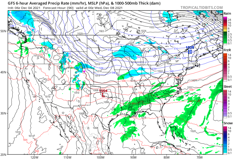
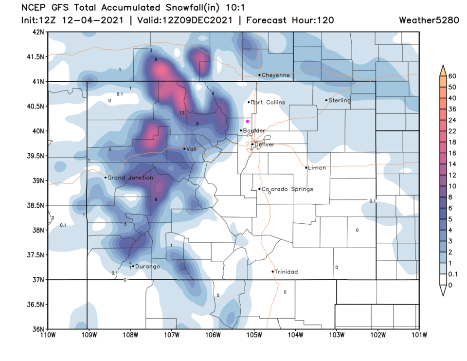
The Longer Range Forecast:

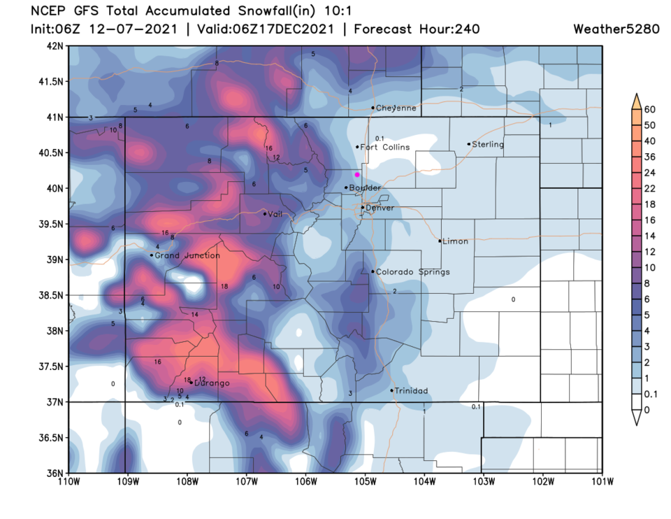
There will be a bit of snow nearby and in the mountains by Tuesday with this front (Figure 3).  Not much precipitation is expected (this DID look like a significant storm a week ago (Figure 4).  Our next storm (IF it materializes) hits Thursday PM and Friday (Figure 5). The snowfall total from the GFS is very significant (Figure 6) with Longmont getting 5-7 inches of snow.  This will finally end out snowless streak (I hope!).

Figure3_12042021
Figure 3: the 6 hour averaged precipitation around Tuesday evening/sunset from the GFS and tropicaltidbits.com
Figure4_12042021
Figure 4: the 10 day (10:1 ratio) total snowfall forecast from the GFS and weather5280.com
Figure5_12042021
Figure 5: the 6 hour averaged precipitation around Friday morning from the GFS and tropicaltidbits.com
Figure6_12042021
Figure 6: the 10 day (10:1 ratio) total snowfall forecast from the GFS and weather5280.com


About the Author: John Ensworth

John Ensworth used to work from Longmont as the PI for the NASA through the IGES (The Institute for Global Environmental Strategies). He now teaches technology, algebra, astronomy, meteorology, film school, and Lego robotics to middle/high school.
Read more


Comments


Current Weather

Sunny

Sunny

47°F

UV Index
3 Moderate
Pressure
29.73 Steady
Visibility
8 miles
Dewpoint
18 °F
Humidity
32%
Wind
SW 3.6 mph
Gust
8.7 mph
Wind Chill
45 °F

Hourly Forecast

Today
9 AM
47°F
Intermittent clouds
Today
10 AM
51°F
Intermittent clouds
Today
11 AM
54°F
Intermittent clouds
Today
12 PM
56°F
Intermittent clouds
Today
1 PM
57°F
Intermittent clouds
Today
2 PM
58°F
Intermittent clouds
Today
3 PM
58°F
Intermittent clouds
Today
4 PM
58°F
Intermittent clouds
Today
5 PM
57°F
Intermittent clouds
Today
6 PM
56°F
Intermittent clouds
Today
7 PM
54°F
Intermittent clouds
Today
8 PM
51°F
Intermittent clouds

7 Day Forecast

Intermittent clouds

Wednesday

58 °F

Breezy and cool with times of clouds and sun


Mostly cloudy w/ showers

Wednesday Night

39 °F

Increasing clouds with a shower in spots late


Partly sunny w/ showers

Thursday

54 °F

Times of clouds and sun with a couple of showers; cool


Partly cloudy

Thursday Night

43 °F

Partly cloudy


Mostly cloudy

Friday

60 °F

Mostly cloudy


Clear

Friday Night

42 °F

Clear


Mostly sunny

Saturday

68 °F

Mostly sunny


Mostly cloudy w/ t-storms

Saturday Night

43 °F

Mostly cloudy with showers and thunderstorms late


Mostly cloudy

Sunday

68 °F

Becoming cloudy with a thunderstorm in spots in the afternoon


Partly cloudy

Sunday Night

47 °F

A thunderstorm in the evening; otherwise, partly cloudy


Sunrise and Sunset

Sunrise
5:51 AM
Sunset
8:03 PM

Based on AccuWeather data