In Brief:
Temperatures remain mild for the next week with daily afternoon thunderstorms. However, the weekend and beginning of next week will look much like this week with a wet weekend and soggy through the start of next week.
Sunday AM forecast update:
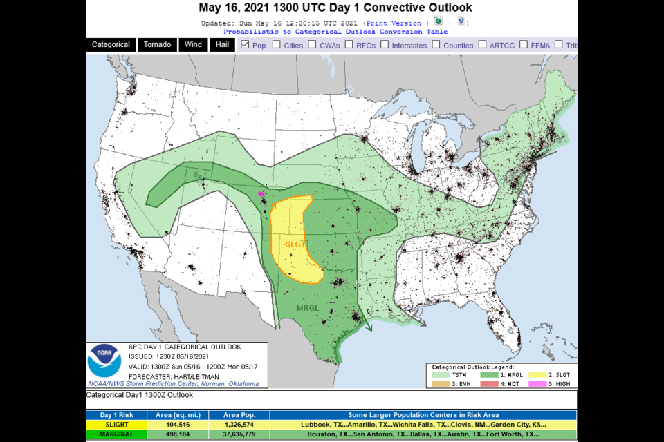
Storms have been widely scattered the last few days - Longmont has missed all but some light sprinkles. The same might be true today until a more steady rain arrives. Rain chances climb after 3pm and don't really drop until Tuesday AM. Models give us about 1/2 to 1 inch of water through this period. There is a Marginal chance of severe weather this afternoon (Figure 4 update) with hail and high winds being the risk. There is a risk of a few tornadoes out in the yellow Slight Risk zone.
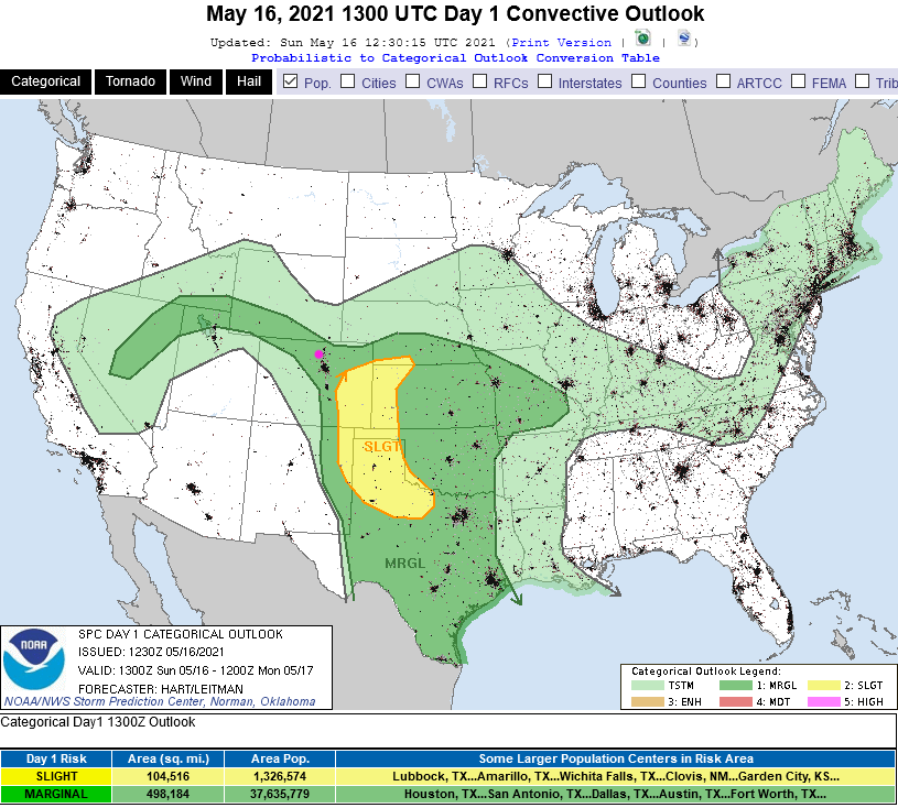 Figure 4 update: the SPC severe storm forecast for Sunday.
End Sunda AM forecast.
Saturday forecast update:
The western trough/low has inched a bit closer to Colorado, even more moisture has been pulled in to the state and temperatures are a touch warmer as well. With these ingredients coming together, the SPC has upped the chance of severe weather. We have a Slight risk of severe weather now including all the major cities along I25 (figure 2 update). The risk of a tornado or two also includes these locations (Figure 3 update). The risk of large damaging hail and strong damaging straight line winds map looks almost the same as the tornado map below with a chance of hail and damaging winds including the mountain communities as well. Today will be a more active day! Keep an eye on the sky and your apps.
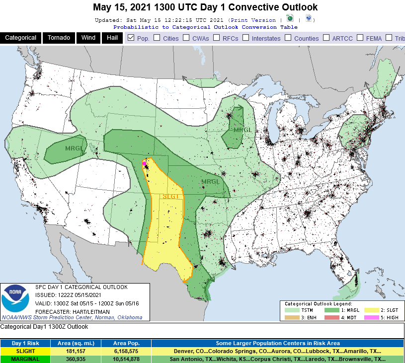 Figure 2 update: Saturday's SPC severe storm forecast.
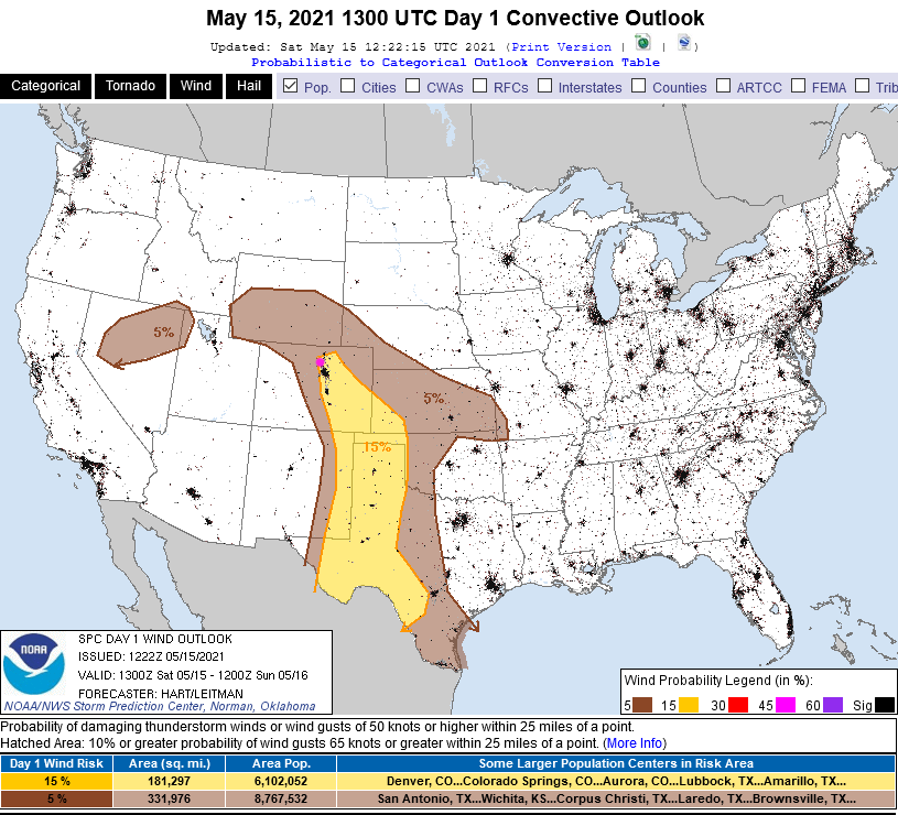 Figure 3 update: Saturday's SPC tornadic storm forecast.
End Saturday's forecast.
Friday forecast update:
The Storm Prediction Center in Norman, OK has updated their severe storm outlook for today, Saturday, and Sunday (Figure 1 update). The I-25 cities, the foothills and northern Colorado mountains are all under a Marginal risk (1 on a scale of 1-5 in severity). High winds and damaging hail is possible in the dark green areas. There is a Slight Risk in the yellow out on the Plains. Isolated tornadic thunderstorms are possible out there.
Our region is under a Marginal risk Saturday and Sunday as well as moisture and warmth increases. Keep an eye on the western and northwestern sky for those dark thunderstorm bases!
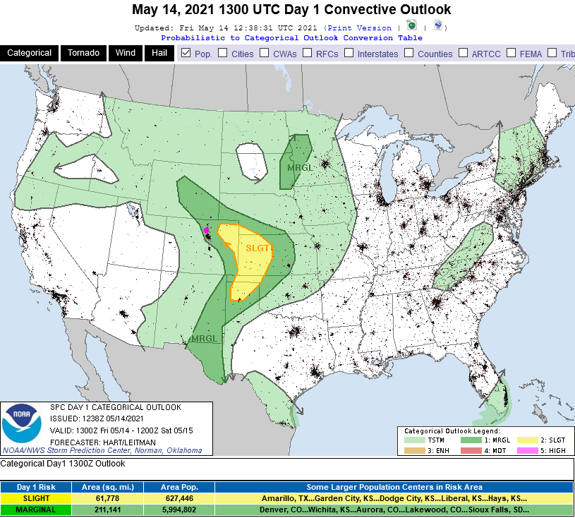 Figure 1 update: the SPC severe storm forecast for Friday.
End Friday forecast update.
Forecast Discussion:
If there is a theme for this next week, it is more rain and thunderstorms. Moisture is getting pulled into the state as another very slow cut-off low begins to drift toward Colorado. With warmer temperatures and a very moist land and atmosphere, afternoon thunderstorms will become the norm. Will they become severe sometimes? (Figure 1).
For Friday, there is a marginal risk just to our east for large hail and damaging straight-line winds (Figure 2). The marginal risk sinks just a bit to the southeast on Saturday, but isn't far away (Figure 3). We'll have to keep an eye on that region being extended westward as the weekend approaches. I put a box around the afternoon storm chances in Figure 1. It is like a heartbeat graph.
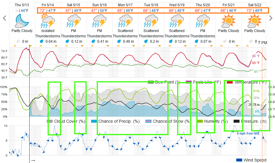 Figure 1: the 10 day graphical forecast from weatherunderground.com for Longmont, CO.
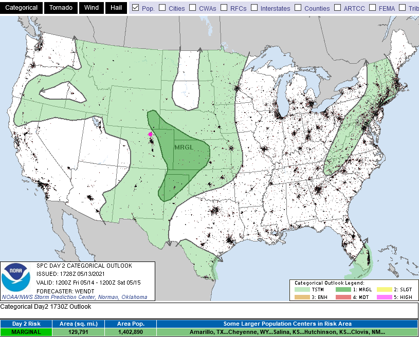 Figure 2: the risk of severe weather from the Storm Prediction Center, Norman OK for Day 2, Friday.
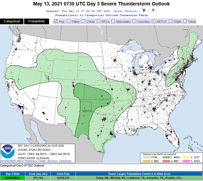 Figure 3: the risk of severe weather from the Storm Prediction Center, Norman OK for Day 3, Saturday.
The Longer Range Forecast:
By Monday, the low is still to our west (Figure 4) but, as it drifts eastward, more steady rain chances will set in Sunday through Tuesday or Wednesday (Figure 1). The abnormally high amounts of atmospheric moisture (green shading in Figure 5) is streaming almost directly up from the Gulf of Mexico. The over-achieving GFS gives us almost 2 inches of rain over the next 10 days with areas of over 3.5 inches all around. Even if that is overdone, a lot more moisture is coming in. More of NE Colorado is now drought-free. Great news! Enjoy a wet Springtime pattern!
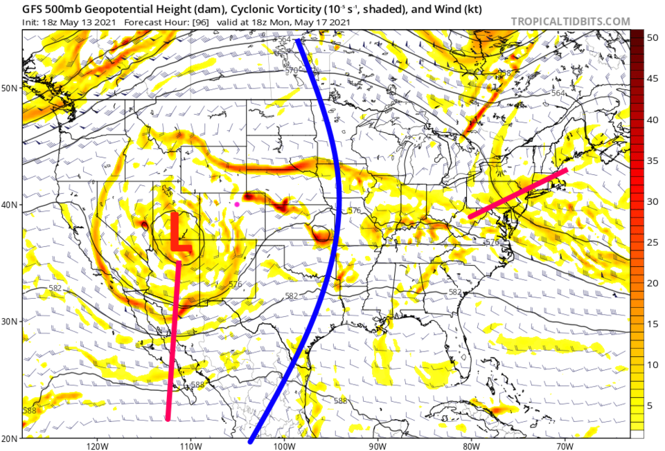 Figure 4: the 500mb upper air forecast map for Monday noon from the GFS and tropicaltidbits.com
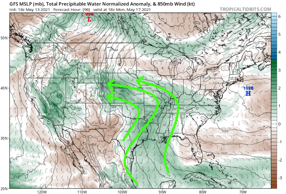 Figure 5: the precipitatable water anomaly (departure from normal) for Monday noon from tropicaltidbits.com
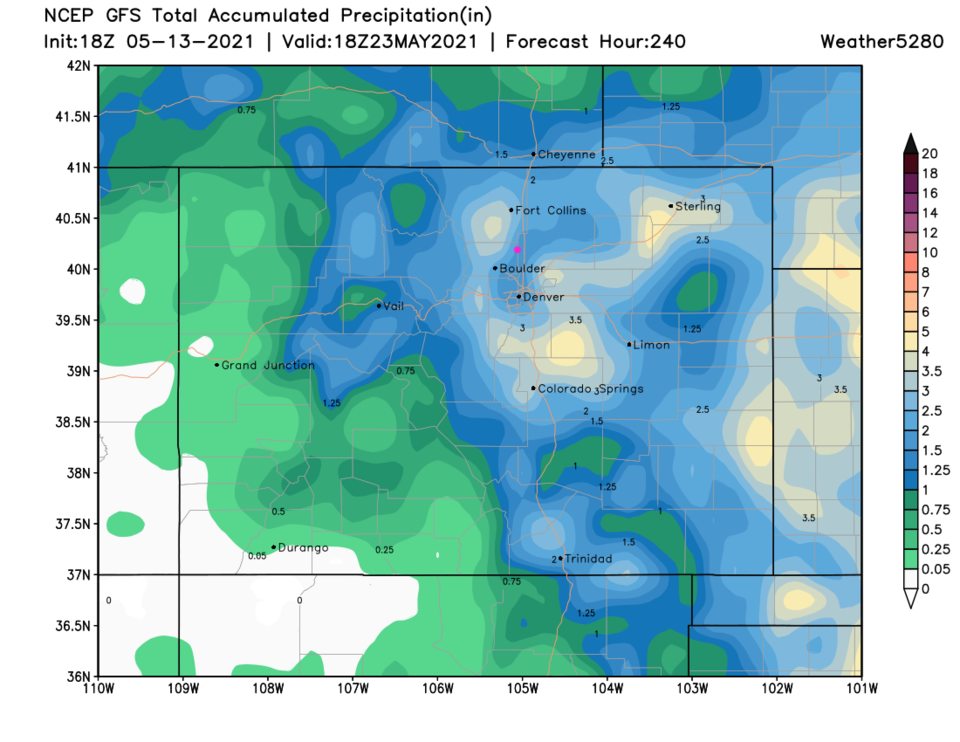 Figure 6: the 10 day precipitation total from the GFS and weather5280.com


